
Route: Circuit of Mellbreak
Area: Western Lake District
Date of walk: 15th January 2015
Walkers: Andrew
Distance: 7.7 miles
Weather: Mostly overcast – very windy!
I decided against a fell walk today after reading the Mountain Weather Information Service forecast, which did not mince its words – ‘mobility tortuous’, ‘severe wind chill’, ‘whiteout likely’, ‘visibility appalling’, ‘will feel like minus 21C directly in the wind’ – these were a few of the predictions that convinced me that it would be foolhardy to venture up on to the fells
Although I couldn’t climb a fell today, I could walk round one, and Mellbreak is a good candidate for such an enterprise as it stands on its own, unconnected to other fells
I parked in the National Trust car park at Scale Bridge and followed the track down to the foot of Crummock Water. There was a howling wind blowing along the lake, making it look more like the North Sea. I walked round the foot of the lake, but had to make a detour near the Pump House as I was in danger of being blown off the narrow wall
Having regained the edge of the lake, I walked along the western shore watching squalls of wind lift water off the surface of the lake. Although it’s an easy path it was a struggle walking directly into the wind, and on occasions strong gusts almost brought me to a standstill
After rounding the southern end of Mellbreak, I entered lonely Mosedale – a desolate place. It was a squelchy journey along the sodden path, though I made quick progress as the wind was now at my back and it propelled me along. After reaching the end of Mosedale, I walked along quiet country lanes back to the start
Click on the icon below for the route map (subscribers to OS Maps can view detailed maps of the route, visualise it in aerial 3D, and download the GPX file. Non-subscribers will see a base map)

Scroll down – or click on any photo to enlarge it and you can then view as a slideshow

Red squirrel in the garden before I set off this morning

Nothing beats a good scratch


On with the walk - a full River Cocker by the car park at Scale Hill, with Mellbreak in the background

The path through Lanthwaite Wood to the foot of Crummock Water

The foot of Crummock Water

It was blowing a gale, and a struggle to hold the camera steady

The water which was being blown off the lake was flooding the usual path, but I persevered

Further along the lakeshore path, crossing the bridge over Park Beck

I tiptoed along the top of the wall, and was almost blown off a couple of times

Another section of wall, which was being submerged by incoming squalls, so I headed inland at this point

The High Stile Range before I head away from the lake


Looking back to Grasmoor

Mellbreak

Approaching Highpark at the foot of Mellbreak

Grasmoor again

These herdies demonstrate that dry stone walls aren’t just for enclosure - they offer protection from the elements as well

A lovely section as I walk along the elevated path towards Haystacks and Great Gable

Rannerdale Knotts to the left

That’s not mist - it’s water being blown off Crummock Water behind the headland

There are two paths along the shore of the lake, and I’m on the higher one


Rannerdale Farm and Rannerdale Knotts on the other side of the lake

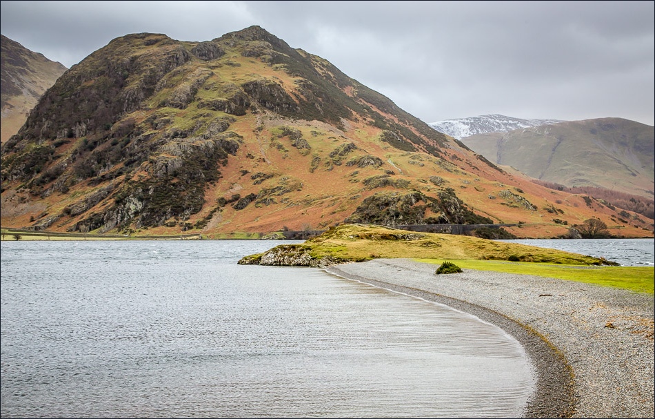
The narrow promontory of Low Ling Crag juts out into the lake

Low Ling Crag, with Rannerdale Knotts behind it

Sheepfold as I start to climb away from Crummock Water

The halfway point as I approach Mosedale

Scale Beck

Looking back to Crummock Water

Another look back from higher up before I head into Mosedale

A complete contrast with what has gone before - a featureless wilderness - but wonderful all the same

The final glimpse of Crummock Water before heading into Mosedale

A redundant gate - one of the few features in this lonely place


Looking back to the Mosedale Holly Tree - the only tree to be named on the OS maps.

The flooded path along the valley - Hencomb is to the left, with Darling Fell and Low Fell ahead

Walking above Flass Wood, which always seems to appear desolate

Park Bridge

Haystacks and Great Gable, just before I arrive back at the start
