
Route: Llyn Crafnant and Llyn Geirionydd
Area: North Wales
Date of walk: 20th September 2021
Walkers: Andrew and Gilly
Distance: 5.8 miles
Ascent: 1300 feet
Weather: Sunny
The two lakes of Llyn Crafnant and Llyn Geirionydd are in a wonderful setting, encircled by mountains and forests, and both can be visited in the course of a single walk. We parked in the Forest Enterprise car park, which is free, and is located near the foot of Llyn Crafnant. Instead of walking towards the lake we followed the lane away from it and turned off just before reaching a cottage ‘Hendre Isaf’
We crossed a narrow pedestrian bridge to the left and reached a mining area with ruined buildings and spoil, known as Klondyke Mill. We climbed onto the spoil heaps and located a faint path into the woods. There was some uncertainty here, as the path was clearly little used and didn’t follow the course of the public footpath shown on our OS map. However, we soon joined up with the public footpath and from this point on navigation was obvious
After a short climb Llyn Geirionydd came into view. We made a short detour to a monument, erected in 1850 by Lord Willoughby d’Eresby, which provides a fine viewpoint over the lake and the steep hillside of Mynydd Deulyn. We descended to the shoreline and followed a path along the west side of the lake. This involved a clamber over a rocky headland at one point
Beyond the head of the lake we changed direction to aim for Llyn Crafnant. The path took us through an area of recently cleared forest, a scene of devastation. It was a relief to descend to Llyn Crafnant and follow an attractive lane beyond the head of the lake (which is in fact a reservoir). We left the lane to join a track across the head of the lake and then joined the forestry track along its shoreline. It was very easy walking, but sadly there were very few opportunities to descend to the lakeshore itself and so the views were somewhat restricted. On reaching the foot of the lake we were compensated by a wonderful view back along it, a great climax to the walk. After savouring the view for a while we walked along the lane to the nearby car park to end our walk
Click on the icon below for the route map (subscribers to OS Maps can view detailed maps of the route, visualise it in aerial 3D, and download the GPX file. Non-subscribers will see a base map)

Scroll down – or click on any photo to enlarge it and you can then view as a slideshow

The start of the walk from the Forest Enterprise car park. Llyn Crafnant is a short stroll away, but we head back down the lane and will visit the lake at the end of the walk

We follow the lane in the direction of Trefriw

Just beyond a cottage, Hendre Isaf, we leave the lane and cross a narrow bridge

We head towards Klondyke Mill

Klondyke Mill is an old mining area. According to our Pathfinder Guide, the way onward is not 'abundantly clear'. This is true, but we eventually found a narrow path leading up through the woods which connected with a wider path

A view back as we seek out the main path (I believe that the Pathfinder Guide is wrong in taking us through the old mill (as can be seen from the OS map)

On the correct path now, Llyn Geirionydd comes into view

We pass by the Taliesin Monument, erected by Lord Willoughby D'eresby circa 1850 to commemorate the reputed birthplace of Taliesin, a famous bard of the 6th century

View of Llyn Geirionydd from the monument

We descend to the lakeshore

We follow a path beside the lake...


Approaching the head of the lake

At the head of the lake we turn right to enter into woodland

This is Forestry Commission woodland - recent felling detracts from the scenery as we climb up a rise before descending towards Llyn Crafnant

It's good to leave the devastation behind us as Llyn Crafnant comes into view

It's possible to turn right at the lane for a shorter way back, but we preferred to turn left and walk around the head of the lake

We follow an attractive lane for a while

Llyn Crafnant

Crimpiau and Craig Wen ahead

We join a track which takes us across the head of the lake...


Looking back to the deforested area which we'd passed through earlier


A memorial bench as we reach the lake...

A view of Crimpiau from the bench

Another view back as we continue along the easy track

A woodland section near the foot of the lake

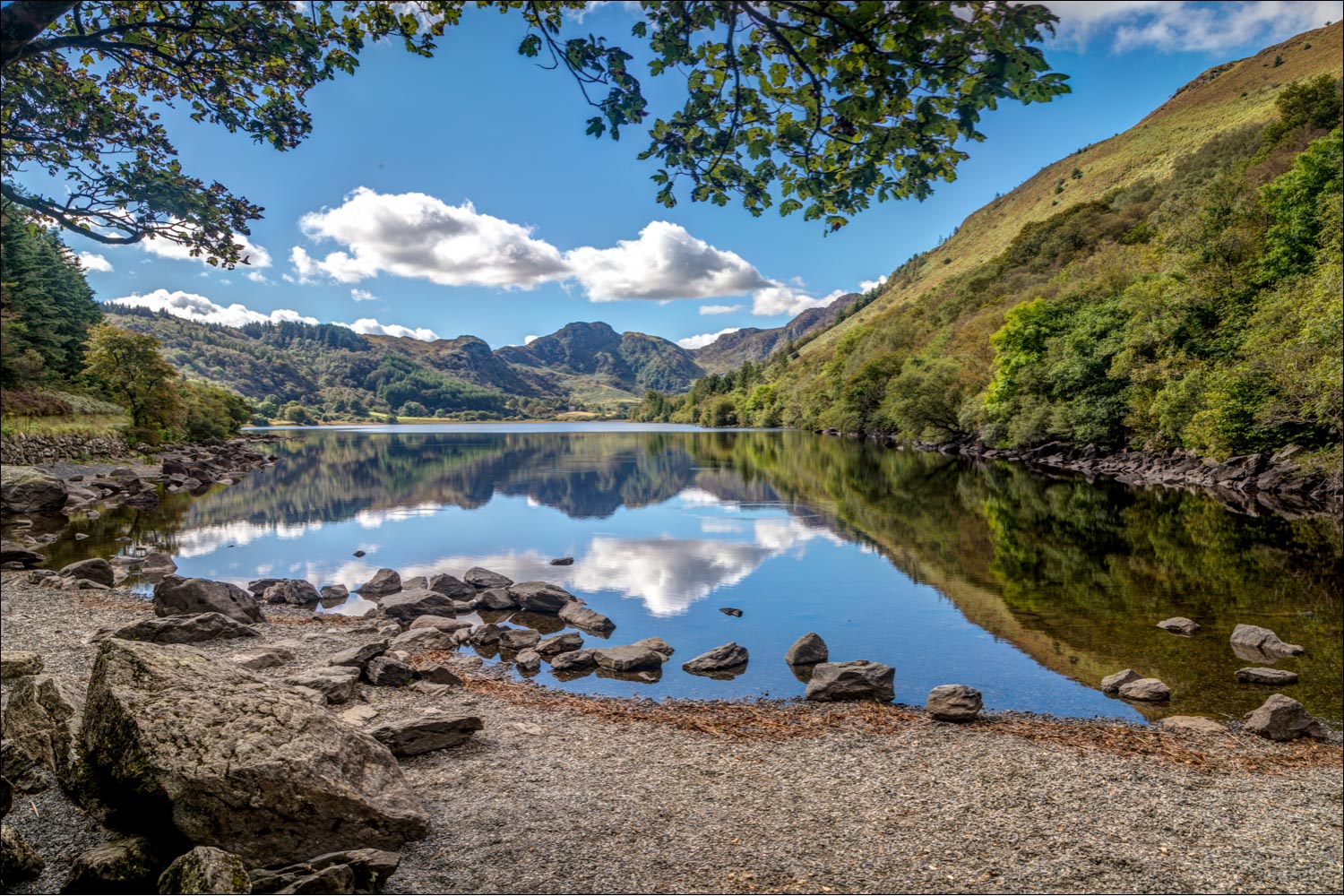
The wonderful view of Crimpiau from Llyn Crafnant

A great end to the walk, and from here we turn our back on the lake and walk back to the nearby car park
Follow the link for more walks in Wales (17)
