
Route: Lingmoor Fell
Area: Southern Lake District
Date of walk: 15th February 2019
Walkers: Andrew and Gilly
Distance: 8.6 miles
Ascent: 2,200 feet
Weather: Sunny and cloudless
Lingmoor Fell is wonderfully positioned between Great Langdale and Little Langdale, and as a result enjoys great views of both valleys as well as the surrounding fells. As Alfred Wainwright says ‘There is no better place than the top of Lingmoor Fell for appraising the geography of the Langdale district’
We parked in the National Trust car park in Elterwater and crossed the road bridge over Great Langdale Beck, passing through the quarries mined by Burlington Slate. Lingmoor Fell is renowned for its beautiful green slate and has been extensively mined for it
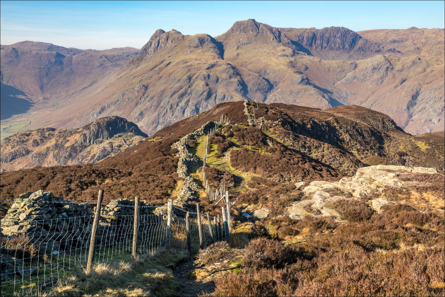
We followed an old mining track for a while before leaving it to climb up the open fellside to gain the summit ridge, where views towards Windermere opened up. Sadly the long distance views were very hazy today. We then followed the undulating ridge to the summit cairn on Brown How, one of the best places to admire the Langdale Pikes. The ridge then continues beside a dry stone wall which resembles a rollercoaster as it snakes up and down. Some of the descent sections are quite rocky and steep, and at one point we had to resort to some bottom shuffling. Judging by the highly polished surface of the rocks we were not the first to employ this ungainly but useful technique
Eventually we encountered the rock wall of Side Pike, the top of which is accessible via a narrow path to the left, but this does not provide a way off the fell. Just before reaching it we descended in the direction of the road to Little Langdale. Last time I was here I returned via Great Langdale and the Cumbria Way, but today we decided to try a different route and return via Little Langdale. On reaching the road (a narrow gated lane which is unfrequented by traffic) we made a short detour to walk around Blea Tarn, a beauty spot which should not be omitted on this round if time permits
We rejoined the lane, known as Side Gates, and after a short distance left it to join a path which runs above the road. This was faint at times, and involved several ups and downs which proved to be quite tiring at the end of a long fell walk. Anyone wishing to avoid this extra effort could simply continue along the road, which is virtually traffic free. Note that in late summer this section of the route is covered with high bracken and the roadside alternative may be preferred. After passing through Sawrey’s Wood we arrived back in Elterwater hot and tired, but this was soon remedied by a visit to the excellent Britannia Inn, conveniently situated near the car park
For other walks here, visit my Find Walks page and enter the name in the ‘Search site’ box
Click on the icon below for the route map (subscribers to OS Maps can view detailed maps of the route, visualise it in aerial 3D, and download the GPX file. Non-subscribers will see a base map)

Scroll down – or click on any photo to enlarge it and you can then view as a slideshow

After leaving the National Trust car park in Elterwater, we cross the bridge over Langdale Beck and turn right along the track

Great Langdale

Early evidence of the mining activity in these parts

We follow a path beside Langdale Beck


We leave the beck shortly after this point to enter the slate quarries

Burlington Stone quarry here - the Langdale Pikes in the background made a strange juxtaposition, but this is part of the history of lakeland

After leaving the quarry we turn left ahead to start the climb up to Lingmoor Fell

Sawrey's Wood

We enter onto open fellside, where progress is made easy thanks to an old mining track

Looking back to the track, with Chapel Stile below...

...and the quarry comes into view a little higher up

We leave the mining track here to follow the sign which points up the fellside

We gain the summit ridge, here looking back to Chapel Stile

Wetherlam on our left

A hazy glimpse of Windermere in the distance

Looking back along the path

We pass by an old stone bench

The Langdale Pikes come into view

We follow the rollercoaster dry stone wall along the ridge...

...looking back

The summit of Lingmoor Fell top left

We climb the stile to reach the highest point of Lingmoor Fell

The summit cairn

We continue along the ridge, with views of Pike o'Blisco, Bowfell, Loft Crag and Harrison Stickle ahead

Looking down to Blea Tarn - we'll be walking around the back of the tarn later

Bowfell and the Langdale Pikes again

Side Pike ahead

We descend beside the dry stone wall and will turn left just before reaching Side Pike

We follow the path downhill in the direction of Blea Tarn - there's a choice between following the road to the left or turning right to walk behind the tarn. We choose the latter

Looking back up to Lingmoor Fell, with Bleatarn House on the right

At the top of the pass leading into Great Langdale we turn left to join a path to Blea Tarn

Blea Tarn ahead

Looking back along the path


We join the path leading back to the road

Blea Tarn - Side Pike is on the right

The Langdale Pikes in the background...


We join the narrow road into Little Langdale - traffic is not an issue as it's a little used gated road

Looking back to the Langdale Pikes

The moon appears above our heads as we follow a path above the road

Little Langdale Tarn

There are several ups and downs along the faint path, and tired legs may find it easier to follow the road, which is below

Little Langdale...


Little Langdale

Elterwater

Refreshments at the Britannia Inn, which caters for all tastes, including a dog chew for Bonnie
