
Route: Latrigg
Area: Northern Lake District
Date of walk: 4th August 2018
Walkers: Andrew
Distance: 6.4 miles
Ascent: 1,200 feet
Weather: Cloudy with a few sunny spells
I normally try to avoid crowds when planning the place and time for a walk, but today I broke that habit and joined a crowd, or rather a rally. The Lake District National Park Authority, already much criticised for its support for the doomed zip wire project in Thirlmere, has again risked the wrath of local residents and lovers of the Lake District landscape by including in the Local Plan review a proposal for a gondola-style cable car up to the Whinlatter Visitor Centre. In order to voice concern about this absurd proposal Friends of the Lake District had organised a rally on Latrigg and I wanted to show my support
The meeting place was at Spooney Green Lane, the usual starting point for an ascent of Latrigg. I arrived early and set off ahead of the rally in order to enjoy the views without too many other folk in the way. I parked in one of the roadside spaces near Spooney Green Lane and joined the Cumbria Way to cross the bridge over the A66. The wide track then took me through Latrigg Wood onto open fellside, and from here I followed the zigzag path to the summit of Latrigg. The views from this fell are out of all proportion to its modest stature, and are quite breathtaking – some of the best in the district
Having savoured these for a while I retraced my steps for a short distance and then branched off to the Gale Road car park where the rally had gathered. Speeches were made by Douglas Chalmers, the CEO of Friends of the Lake District, followed by film maker Terry Abraham and finally Lord Clark of Windermere. Each of them spoke eloquently and passionately about the issues at stake. After hearing representations from some local residents the meeting broke up and it was time to carry on with the walk. I followed a path which descends gently beside the northern slopes of Latrigg, with some wonderful views ahead of me all the while. When I reached the toe of the fell I started the return journey through Brundholme Wood, most of which is along a narrow metalled track and is very easy going
As I made my way back to the start, admiring the views of the surrounding fells, I tried to comprehend what motive there could be for installing a cable car in the midst of such a landscape, now a UNESCO World Heritage Site. I could think of none, apart from the pursuit of money regardless of all other consequences. It is mystifying, and rather worrying, that the National Park Authority is in support of such a scheme
For other walks here, visit my Find Walks page and enter the name in the ‘Search site’ box
Click on the icon below for the route map (subscribers to OS Maps can view detailed maps of the route, visualise it in aerial 3D, and download the GPX file. Non-subscribers will see a base map)

Scroll down – or click on any photo to enlarge it and you can then view as a slideshow

The day before the walk, a red squirrel in the garden

I leave before the main group and walk up Spooney Green Lane, with a view of Latrigg - today's objective - to the right

Entering Latrigg Wood

Looking back to the North Western fells

Further along Latrigg Wood

I enter onto open fellside beyond the wood

North Western fells, with Causey Pike on the left and Grisedale Pike on the right

Zooming in on Newlands Valley behind Derwent Water

Catbells in the centre of the picture

Looking back to Portinscale and Braithwaite

Start of the zigzag path up to Latrigg...

...a zig looking to the North Western fells...

...and a zag looking towards Blease Fell

Redundant gatepost at one of the turns along the path

Keswick, Derwent Water, and Catbells

I continue up the easy path

Looking back to Skiddaw Little Man, with Skiddaw just out of sight in the clouds

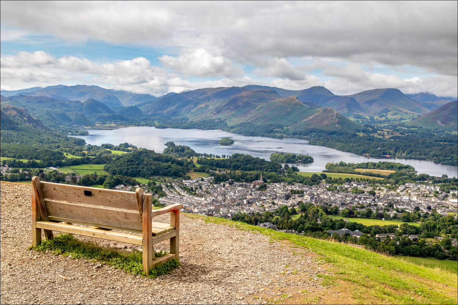
The bench just below the summit of Latrigg

The stupendous view of Keswick, Derwent Water, and too many fells to list

From the summit of Latrigg, looking back along the ridge, with Grisedale Pike on the right

That view again, seen as I retrace my steps in order to catch up with the rally

Looking across to Skiddaw as I make my way over to the Gale Road car park, where the rally is being held


Douglas Chalmers again, CEO of the Friends of the Lake District, and in the background is the site of the proposed gondola/chair lift...


A last rallying call from Terry Abraham, Lord Clark, and some of the concerned residents of Thornthwaite, whose lives will be blighted if the scheme goes ahead

We all go our different ways, and I follow this track heading east

Looking up to Skiddaw and its Little Man

Great Mell Fell in the distance...


Blease Fell, leading up to Blencathra, on the left

High Rigg and the eastern fells on my right

I continue to follow the easy path, still heading east

A glimpse of Derwent Water as I look back

Blease Fell again as I reach the end of the descent ridge

The half way mark, and here I round the toe of Latrigg to start the return leg

I follow a track beside the edge of Brundholme Wood...


The track is officially closed here, but the rally has made me feel rebellious and I carry on regardless. Law abiding citizens can divert along a footpath lower down in the woods

Further along the track, where there are no obstacles whatsoever (this may not be the case on a weekday, so it may be prudent to obey the signage)...


The other end of the road closure

I cross the bridge over the A66 and continue along the quiet road

Looking towards Skiddaw as I approach Spooney Green Lane and the end of a wonderful and thought provoking walk

Eloquent and passionate speeches from people who care about the Lake District National Park - Lord Clark of Windermere, filmmaker Terry Abraham on the other side of the lens for a change, and Douglas Chalmers and Ruth Kirk of Friends of the Lake District
