
Route: Lanthwaite Hill
Area: Western Lake District
Date of walk: 27th August 2022
Walkers: Andrew and Gilly
Distance: 3.0 miles
Ascent: 800 feet
Weather: Sunny
Lanthwaite Hill, otherwise known as Brackenthwaite Hows, is one of my favourite places in the Lake District. This place has featured on my site many times, but I take the view that no two walks are ever the same – changing seasons and variations in the light and weather make for an infinite number of possibilities – and there’s always something new to be seen
The hill and surrounding woodland have recently been purchased by the National Trust, which will preserve this place for future generations
Today’s walk was a slight variation on our usual one, and was made up as we went along. We know the area well and various paths (not all of them shown on the OS maps) offer a number of opportunities. We parked in the National Trust car park at Scale Hill and, instead of taking the obvious path though Lanthwaite Wood, we turned left uphill. At a junction we continued upwards and clambered up a series of steep rock staircases to reach the edge of the wood. We passed through the deer gate and climbed the ridge leading to the top of Lanthwaite Hill, a superb vantage point with views of Crummock Water, Loweswater and Lorton Vale
We normally descend towards Crummock Water, but today we turned away from the lake and headed north along Brackenthwaite Hows to the Buttermere road. We crossed the road at Beck House, then the footbridge over Liza Beck and, after a short boggy section joined the wonderful path along Lorton Vale. This brought us to Lanthwaite Green and from here we re-entered Lanthwaite Wood. We descended to the boathouse by the shore of Crummock Water and from here followed the track back to the Scale Hill car park to end a wonderful short walk
For other walks here, visit my Find Walks page and enter the name in the ‘Search site’ box
Click on the icon below for the route map (subscribers to OS Maps can view detailed maps of the route, visualise it in aerial 3D, and download the GPX file. Non-subscribers will see a base map)

Scroll down – or click on any photo to enlarge it and you can then view as a slideshow

The start of the walk as we enter Lanthwaite Wood. We'll return via the track ahead, but here turn steeply uphill to follow a narrow path

At a junction we continue uphill and clamber up a series of rock steps

We leave Lanthwaite Wood to enter onto Lanthwaite Hill, also known as Brackenthwaite Hows

Low Fell

Looking north along sweet Lorton Vale

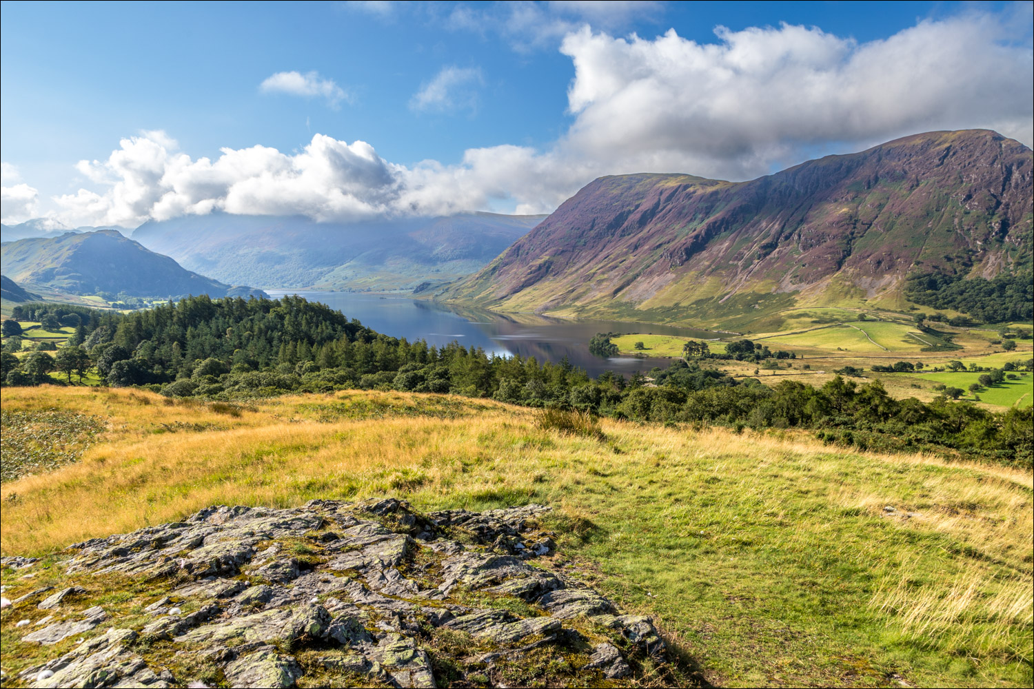
The view south over Crummock Water from the top of Lanthwaite Hill

Looking west to Loweswater

The foot of Mellbreak

Loweswater again

We descend in the direction of Whiteside and follow the line of the ridge as it curves round to the left...


Looking back to Lanthwaite Hill, with Mellbreak beyond

Lorton Vale

We arrive back on the valley floor and pass by Pickett Howe and Beck House

After crossing the Buttermere road we then cross Liza Beck. A short boggy section follows

We walk uphill through a field (no path) towards a gate near the right hand corner

Looking back through the gate to Lanthwaite Hill and Mellbreak

We follow the valley path, with Whiteside on our left

View across to Lanthwaite Hill

Mellbreak and Crummock Water come into view again

We cross Liza Beck for the second time

Good views of Mellbreak as we descend gently to Lanthwaite Green...


We follow a path which will take us past Lanthwaite Green Farm

Looking back to Whiteside before we cross the Buttermere road

We follow the path by the side of the farmhouse

Lanthwaite Wood ahead

We follow a path around the edge of Lanthwaite Wood

Boathouse at the shore of Crummock Water....


We follow the lakeshore path to the foot of the lake

Mellbreak from the foot of Crummock Water, and from here we follow the track back to the start
View from Lanthwaite Hill taken a couple of weeks earlier…
