
Route: Tarn Hows and Holme Fell
Area: Southern Lake District
Date of walk: 15th October 2020
Walkers: Andrew
Distance: 7.1 miles
Ascent: 1,500 feet
Weather: Sunny
Today’s walk is a case of ‘buy one, get one free’ as the route combines two places of beauty, each of which is a worthy destination in its own right. Tarn Hows is one of the most visited spots in lakeland (so arrive early). It is partly artificical, being three tarns joined together in the 19th century. The Tarns were once owned by Beatrix Potter, who left the estate to the National Trust. Holme Fell is a low lying but rugged fell set in the midst of some wonderful landscape, and has superb views in all directions. I’d been saving this walk for a sunny autumn day such as today in order to see the scenery at its best
I parked in the National Trust car park at Glen Mary Bridge and made the short but quite steep climb up to the lakeshore path which runs around Tarn Hows, passing by several attractive waterfalls in Tom Gill along the way. I could have turned left on reaching The Tarns, which would shorten the route but would also miss the best scenery. Instead I followed the path anti-clockwise around The Tarns, making a short uphill diversion at one point to get a better view. On reaching a footbridge at the half way point of The Tarns I reluctantly turned my back on them to make my way over to the next objective, Holme Fell
I joined a path between dry stone walls, part of the Cumbria Way and, after crossing the road a little further on, started the gradual climb up to High Oxen Fell. This was initially along a narrow lane, and then a stony path. Eventually, after passing by the deep quarry at Hodge Close, I left the main path to start the ascent of Holme Fell. The going was straightforward, although there are some steep rocky sections below the summit which involve some clambering. I first visited the impressive cairn on Ivy Crag, which isn’t the highest point of the fell, and then made my way over to the true summit. The views from here are wonderful, especially those looking towards the Langdale Pikes
I descended to Uskdale Gap and followed a path through the woods to Yew Tree Tarn, a lovely spot marred only by its proximity to the Coniston road. I walked beside the tarn, with the road on the other side, and from here it was a short stroll back to Glen Mary and the end of a wonderful walk
For other walks here, visit my Find Walks page and enter the name in the ‘Search site’ box
Click on the icon below for the route map (subscribers to OS Maps can view detailed maps of the route, visualise it in aerial 3D, and download the GPX file. Non-subscribers will see a base map)

Scroll down – or click on any photo to enlarge it and you can then view as a slideshow

The start of the walk as I follow a path uphill beside Tom Gill, which flows out of Tarn Hows

One of several waterfalls in Tom Gill

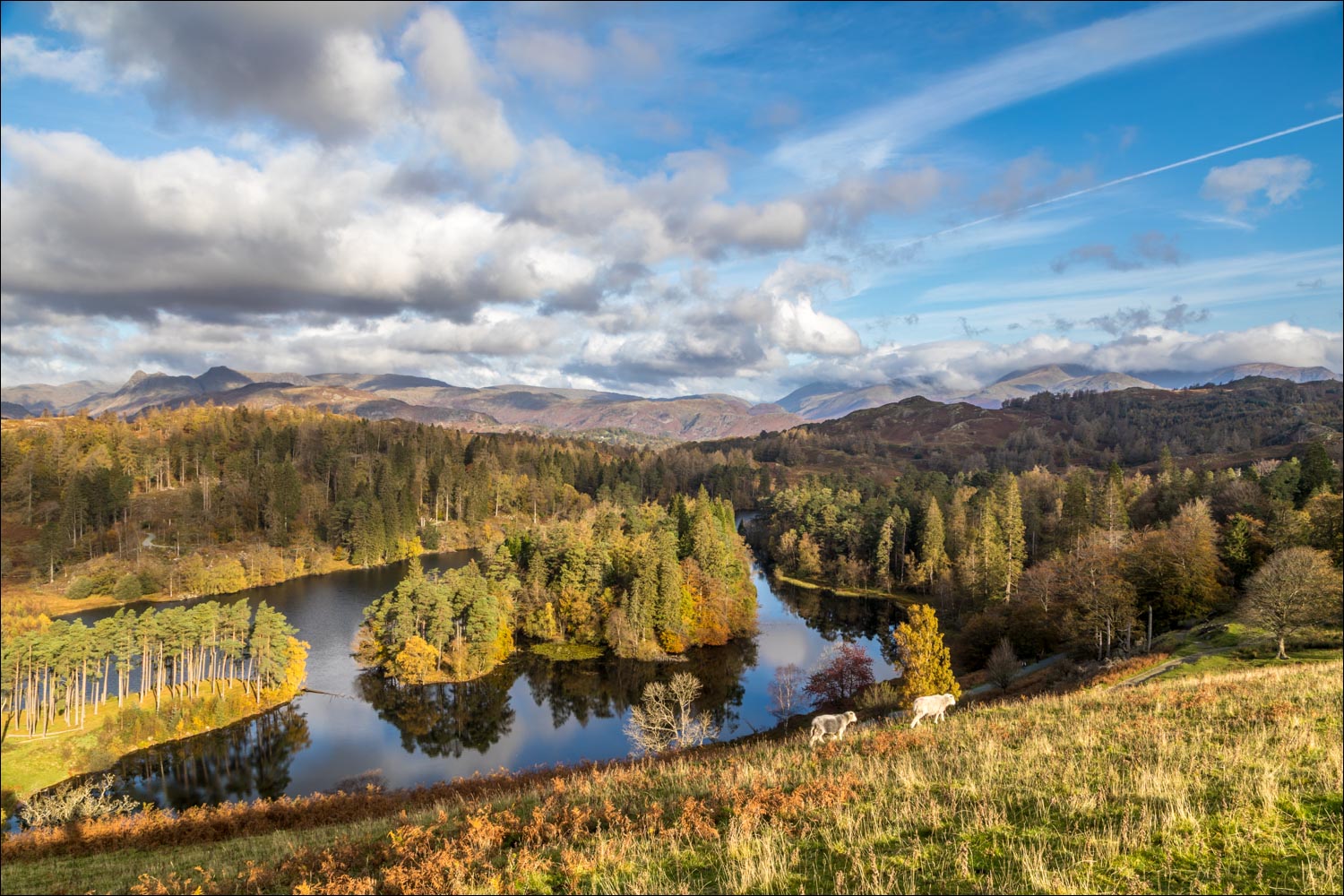
I arrive at Tarn Hows and follow the easy path around the shoreline

Autumn colours around The Tarns...


Reflections in Tarn Hows...


At Rose Castle I climb up a pathless grassy slope to get a wider view. Wetherlam is in the distance, and Holme Fell below it, slightly to the right

View from the top of the hill

Zooming in on the Langdale Pikes

I descend back to Tarn Hows and continue around its shore

Reflections in the tarn...


The circuit continues to the left, but after crossing the footbridge I turn right at the stile

Bench with a view

A final look back to Tarn Hows as I join the Cumbria Way and head for the next destination, Holme Fell

I follow the path between the dry stone walls...


Autumn colours in the woods

Tom Heights

After crossing the Coniston road I follow the lane to Oxen Fell

Idyllic countryside as I walk towards High Oxenfell Farm....


The lane ends at High Oxenfell Farm and beyond it becomes a stony path


I leave the path here and turn left at a sign for Holme Ground and Yewdale

I pass by Hodge Close Quarry, a massive excavation of light green coloured slate, which was worked until the 1960s

Autumn colours in the woodland


Holme Fell comes into view, summit unseen from here

Looking across to the Langdale Pikes as I start the climb up Holme Fell

I make my way to Ivy Crag, a subsidiary summit on Holme Fell

The Langdale Pikes again, well seen from Holme Fell

Summit cairn on Ivy Crag, but this is not the highest point of Holme Fell...

...the true summit is over there, below Wetherlam

After a down and an up I arrive at the summit of Holme Fell

The Langdale Pikes from Holme Fell

More views of the Langdale Pikes as I descend to Uskdale Gap

I follow a rocky path down through Harry Guards Wood

Yew Tree Tarn comes into view below Tom Heights

Autumn colours in the woodland around Yew Tree Tarn

I reach the valley floor and turn right to follow a path beside the tarn...


I reach the far end of Yew Tree Tarn, and from here it's a short stroll back to Glen Mary and the end of a fabulous walk
