
Route: Base Brown, Green Gable and Great Gable
Area: Western Lake District
Date of walk: 2nd November 2017
Walkers: Andrew
Distance: 7.5 miles
Ascent: 2,900 feet
Weather: Sunny
I’ve usually approached Great Gable from Honister, but today decided on a different approach. It was a glorious November morning as I drove over the Honister Pass and parked on the roadside verge before the remote settlement of Seathwaite. On reaching the farm I turned right and walked through an arch in the farm buildings, following the path to the River Derwent near the point where it starts its journey into Derwent Water. After crossing the bridge I arrived at Seathwaite Slabs, and this is where the collar work began. I made the stiff climb up the path beside Sourmilk Gill. This involved a mild scramble up the rocks, but there were no difficulties
The gradient slackened as I reached the lonely hollow of Gillercomb and from here it was a steady, but easy climb upwards. When I reached the foot of Green Gable I looked back and Base Brown seemed temptingly close, so I made a detour to the summit of the fell and retraced my footsteps. This ‘there and back’ diversion took about 15 minutes
My next target was Green Gable and as I started the climb the clouds rolled in and I wondered if I’d have any views from the summit. I needn’t have feared as they soon blew by. Having summited Green Gable there followed a steep descent to Windy Gap, aptly named today, and an even steeper ascent up the flanks of Great Gable. The initial part of the ascent involves the use of hands, but it’s perfectly straightforward and, having overcome this section, there just remains a clamber over the rocks to the summit
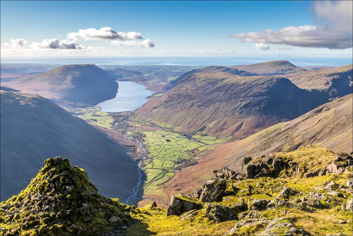
The visibility was good and the views from the top were awe inspiring, especially those from the Westmorland Cairn which is unseen from the summit and lies 150 yards from it. A visit to the cairn should not be omitted as the prospect over Wasdale is possibly the finest mountain view in the whole district. Having savoured it for a while it was time to turn my thoughts to the descent. A line of cairns points the way down to Sty Head and, thanks to some excellent path repairs, it’s relatively easy going. On reaching the plateau I followed the path past Styhead Tarn down to Stockley Bridge and from there back to the start
It had been a red letter day and a privilege to have climbed one of Lakeland’s iconic mountains in such good conditions
For other walks here, visit my Find Walks page and enter the name in the ‘Search site’ box
Click on the icon below for the route map (subscribers to OS Maps can view detailed maps of the route, visualise it in aerial 3D, and download the GPX file. Non-subscribers will see a base map)

Scroll down – or click on any photo to enlarge it and you can then view as a slideshow

Seathwaite Farm at the start of today's walk. Instead of walking through the farmyard as usual, I turn right under the arch

I head towards Sourmilk Gill and follow the steep path on the left bank

I cross the bridge over the River Derwent near its source

The start of the climb up Seathwaite Slabs

Sourmilk Gill waterfalls...


Looking back along the valley - Seathwaite is on the right of the picture

The path levels out as I reach the lonely hollow of Gillercomb

The way ahead. Base Brown, which wasn't on my planned route at this stage, is on the left

Another view back along the valley

Nearing the head of Gillercomb

At the top of Gillercomb I decide to make a there and back diversion to Base Brown, right of picture

After crossing some squelchy terrain, the summit cairn is ahead

Summit of Base Brown, with Skiddaw and Blencathra in the distance

From here I retrace my steps, aiming for Green Gable straight ahead

Looking across to Pillar

The clouds roll in as I approach the path up Green Gable

Looking back to Gillercomb and Base Brown

Dramatic skies

The clouds came and went as I plodded up Green Gable

A gap in the clouds revealed this view along Buttermere and Crummock Water

Looking back down the path

Summit of Green Gable, with Great Gable looming out of the mist

Buttermere and Crummock Water again, with the High Stile Range on the left

I have to surrender some of the height gained by descending steeply to Windy Gap, where the climb to Great Gable starts

Ennerdale

The scrambly section up Great Gable - hands are needed but there are no fears

Looking down to Styhead Tarn, which I'll pass by later on the descent

Grasmoor centre of picture, and Scotland in the far distance

Looking back down to Green Gable and Base Brown beyond it

The War Memorial tablet at the summit of Great Gable. In a few days time this will be the inspiring scene of an annual Remembrance Service attended by hundreds of walkers

Summit cairn on Great Gable, looking towards Wasdale

Pillar in the centre

Out of sight from the summit lies the Westmorland Cairn, erected in 1876 by two brothers who considered the view from here to be the finest in the district

Looking down into Wasdale from the cairn, which stands on the brink of steep crags

Looking across to the Langdale Pikes

The Ennerdale and Buttermere valleys

The start of the descent as I follow a line of cairns in the direction of Great End

Styhead Tarn below - my path will pass by it

I reach the stretcher box at Sty Head

Styhead Tarn

Looking back to Great End

I cross the footbridge over Styhead Gill

The path follow the course of the gill down to the valley

A small wooded area near Greenhow Knott

Seathwaite comes into view

I cross Stockley Bridge


A final glance back up the valley at the end of a memorable fell walk

Later that day, a hedgehog in the garden...

And the next day, a red squirrel
