
Route: Friars Crag
Area: North Western Lake District
Date of walk: 23rd September 2022
Walkers: Andrew
Distance: 3.0 miles
Ascent: 100 feet
Weather: Mostly sunny
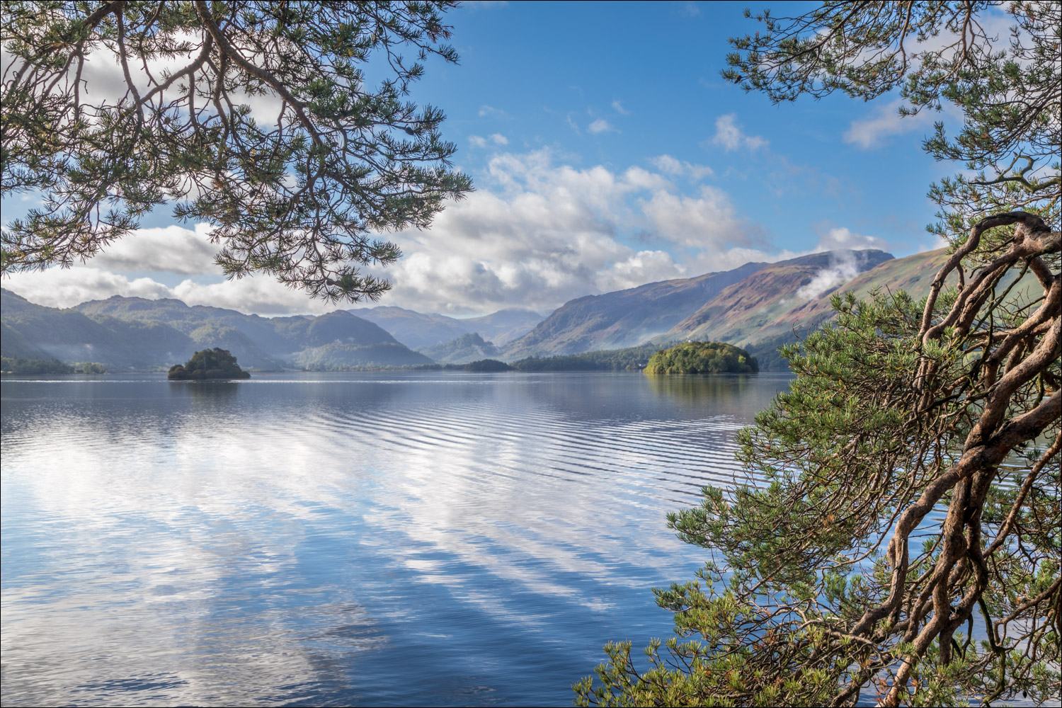
I only had time for a short walk today, and decided to revisit Friars Crag on the east shore of Derwent Water. Friars Crag is a rocky promontory jutting into the lake about half a mile from the boat landing stages. John Ruskin described the view as one of the three most beautiful scenes in Europe
I parked in the large car park next to the Theatre by the Lake on the outskirts of Keswick. After walking past the theatre and Keswick Landing Stages I followed the obvious path leading to Friar’s Crag. There are good views across the lake from the path, which is wheelchair friendly and easy to follow. Along the way I passed by Derwent Isle, owned by the National Trust. The house on the island is inhabited, and is open to the public for five days every year, making it the only inhabited island in the Lake District which opens to visitors
I soon arrived at Friar’s Crag, so named because it was believed to be the departure point for monks making a pilgrimage to St Herbert’s Island, located south west of the crag. The view was as wonderful as ever and after admiring it for a while I carried on around the lakeshore path for a short distance until I reached Strangshag Bay. From here the path heads inland through a marshy area known as The Ings. A raised boardwalk helps to keep shoes dry along this section
I arrived at Calfclose Bay, where a fine bench gives wonderful views to the head of Derwent Water. I continued as far as the Centenary Stone, a modern sculpture set in the bay, placed there to commemorate the Centenary of the National Trust in the Lake District. The stone is carved out of a boulder of volcanic rock from the Borrowdale Valley and the design represents ten segments across ten rings, a century. Differing lake levels mean that the stone is sometimes submerged and sometimes stands on the shore.
My time had run out by now and so from here I retraced my steps, taking an alternative path at Strandshag Bay, to end a short but sweet walk
For other walks here, visit my Find Walks page and enter the name in the ‘Search site’ box
Click on the icon below for the route map (subscribers to OS Maps can view detailed maps of the route, visualise it in aerial 3D, and download the GPX file. Non-subscribers will see a base map)

Scroll down – or click on any photo to enlarge it and you can then view as a slideshow

A dawn visit to Buttermere on the day of the walk, and it's worth sharing a few of the photos


The bothy at the head of Buttermere....


Small waterfall in Hassnesshow Beck as I left the lakeshore

Nearby Crummock Water was looking magical too

Woodhouse Islands

Mellbreak shrouded in mist...


A final look back to Crummock Water as the sun starts to rise

An hour or so later, the start of the walk as I pass by Keswick Landing Stages on the east side of Derwent Water...


Derwent Isle, and Causey Pike beyond

The view from Friar's Crag

Rampsholme Island, the smallest of the four islands on Derwent Water

Looking back to Friars Crag and Causey Pike as I continue along the easy shoreline path

Lord's Island - once home to the Earls of Derwent Water, and connected to the mainland via a drawbridge. Only the foundations of the house remain

A view of Catbells as the path leaves the shoreline in order to circumvent the marshes of The Ings

Looking across to St John's Church Keswick

I pass by some cottages at Stable Hills

St Herbert’s Island, the largest of the islands, covering between four and five acres

Looking back to Lord's Island

I arrive at Calfclose Bay, the far point of today's walk

The Centenary Stone mentioned in the introduction

I retrace my steps back to the start, diverting through Cockshot Wood at one point...


I arrive back at the lakeshore path, and pass by Derwent Isle again

The end of a short but very enjoyable walk
