
Route: Borrowdale
Area: North Western Lake District
Date of walk: 4th July 2019
Walkers: Andrew
Distance: 6.1 miles
Ascent: 800 feet
Weather: Mostly sunny and warm
I’d planned a high level walk today but, on checking the Mountain Weather Information Service, fog was forecast to shroud the higher fells by mid morning, so I decided on a low level walk instead. With only a vague route in mind I set off for Borrowdale, one of the most beautiful valleys in lakeland. I parked in the National Trust car park in Seatoller at the foot of the Honister Pass, although this walk could be started just as conveniently from Seathwaite or Rosthwaite
I turned right just beyond Seatoller and headed along the quiet valley road which leads to Seathwaite. At Seathwaite Bridge I left the road to follow the path to Sty Head, but turned left after a short distance to walk through Seathwaite Farm. The campsite here occupies a wonderful position at the head of the valley, and is a springboard to many of the north western, central, southern and western Cumbrian Fells. I returned along the far side of the valley and, after crossing the Borrowdale road near Seatoller, I joined the lovely path beside the River Derwent. There is one rocky section here at a bend in the river where chains are provided, but don’t let this put you off – it’s a simple clamber and there are no difficulties
As I approached Rosthwaite I decided to return via a higher level path, one which I’ve trodden many times in the past and which offers some wonderful views over Borrowdale. This involves a climb beside Tongue Gill, but it’s worth the effort. The return journey to Seatoller was a delight every step of the way, and I was glad to have included this path in today’s itinerary – it made for a great end to a great walk
For other walks here, visit my Find Walks page and enter the name in the ‘Search site’ box
Click on the icon below for the route map (subscribers to OS Maps can view detailed maps of the route, visualise it in aerial 3D, and download the GPX file. Non-subscribers will see a base map)

Scroll down – or click on any photo to enlarge it and you can then view as a slideshow

Red squirrel before I set off for Borrowdale this morning

On the way to the Honister Pass I stopped the car to take a couple of photos of the head of Buttermere...


A few minutes later, the start of the walk from Seatoller

Looking back to Seatoller and the Honister Pass from the Borrowdale road

I turn off to the right and follow the lane to Seathwaite, which is a dead end so there is very little traffic

At Seathwaite Bridge I leave the lane to follow a path which runs parallel to the road

Base Brown beyond the almost dry stream bed

I cross two footbridges near the southernmost point of the walk, here looking towards Seathwaite Fell

Seathwaite Farm ahead...


Having passed through the farm, I head back along the other side of the valley...


Looking back to Base Brown

One of the many dry stone walls which are to be found in these parts

I follow the quiet lane to Thorneythwaite


At Mountain View I cross the Borrowdale road and continue through the gate ahead...


Folly Bridge

A view back from Folly Bridge

The start of a woodland section beside the edge of Johnny Wood

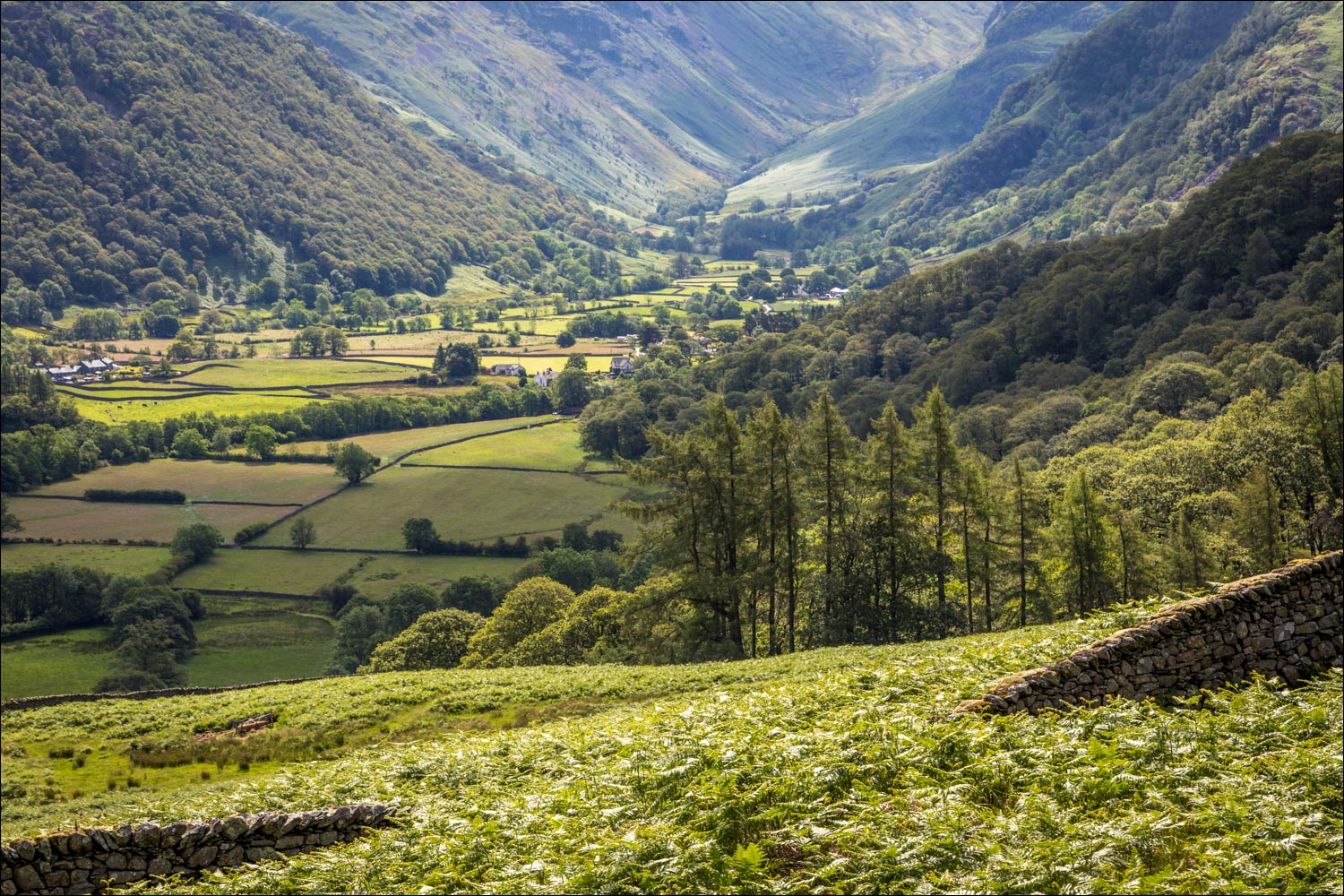
Looking back towards Seathwaite and the head of Borrowdale

A rocky section at the bank of the River Derwent - chains are provided but aren't really necessary and I didn't use them

Looking back along the Derwent

I pass through Borrowdale YHA, where they have found a good way to recycle old walking boots

The stepping stones leading to Rosthwaite - I carry on without crossing

New Bridge, which is very old, and has been sympathetically restored in recent years

I turn away from the bridge and start the climb beside Tongue Gill

Views back into Borrowdale as I gain height...


After a bit of huffing and puffing I reach the mid-level valley path, which has some wonderful views...

Stonethwaite and the head of Borrowdale

The path contours around the lower flanks of High Scawdell...


Looking back to Castle Crag and Grange Fell - the Jaws of Borrowdale


Another view back to Castle Crag

The path heads towards the Honister Pass...


I leave the path here to start the descent back into Seatoller

Borrowdale

Great End in the distance

Seatoller below...


I arrive back in Seatoller to end a wonderful walk
