
Route: Black Fell and Tarn Hows
Area: Southern Lake District
Date of walk: 5th September 2018
Walkers: Andrew and Gilly
Distance: 6.7 miles
Ascent: 1,200 feet
Weather: Sunny
Black Fell stands at 1,056 feet and as such just manages to qualify as a Wainwright. Despite its modest height, the fell is well worth climbing for the superlative views of the Langdale Pikes. I’ve not been here for 4 years, and so a return visit was overdue, particularly since we’d be able to combine the walk with one of Lakeland’s classic beauty spots, Tarn Hows
We parked in the National Trust car park by Glen Mary Bridge and followed the rocky path uphill beside Tom Gill, where there are several lovely waterfalls. After a short while we emerged at the shore of Tarn Hows, whose beauty and accessibility make it a little over popular at times. As we’d anticipated there were quite a few other folk around, but not so many as to spoil the peace. We followed the easy path anti-clockwise around the shore, diverting briefly uphill for an improved view of the tarn, and the Langdale Pikes in the distance – a wonderful sight
After soaking in the views for a while we headed away from the tarn passing by Torver Intake and then joining a path through Iron Keld Plantation. Beyond the plantation Black Fell came into view and we made our way to the summit over some rough ground. The views from here were superb
From the summit we could see the lovely old farmhouse known as Low Arnside with a backdrop of the Langdale Pikes, and we used that as our guide to descend over more rough ground, eventually joining a clear path near the farm. This took us down to the A593, where we had a choice of routes. Holme Fell can easily be ticked off from here, and it’s also possible to climb back up to Tarn Hows and walk along the other shore. We didn’t have time for either option today and, after a brief diversion to Low Oxen fell to avoid the road, we followed the narrow path which runs near the A593, and then skirts around lovely Yew Tree Tarn. This brought us back to Glen Mary Bridge and the end of a wonderful walk
For other walks here, visit my Find Walks page and enter the name in the ‘Search site’ box
Click on the icon below for the route map (subscribers to OS Maps can view detailed maps of the route, visualise it in aerial 3D, and download the GPX file. Non-subscribers will see a base map)

Scroll down – or click on any photo to enlarge it and you can then view as a slideshow

The start of today's walk as we leave Glen Mary car park to start the climb up to Tarn Hows

Lane Head Coppice

Waterfalls in Tom Gill...


After a short climb we arrive at the shore of Tarn Hows

We walk anti-clockwise around the tarn...

When the tarns and surrounding land came up for sale in 1929, they were bought by Beatrix Potter who sold the half containing Tarn Hows to the National Trust, and bequeathed the rest of the estate to the Trust in her will

The tarn is partly artificial, being three tarns joined together in the 19th century

We follow the easy path around the eastern shore...


Tarn Hows

We make a short there and back detour uphill for this view towards the Coniston Fells

We leave Tarn Hows here to walk towards Black Fell

Views of the Langdale Pikes as we walk across Torver Intake

Windermere

We join the Cumbria Way for a short distance...


We leave the Cumbria Way to follow a path through Iron Keld Plantation

Mushrooms galore as we walk through the woodland...


We emerge from the plantation to be greeted by this view of Bowfell and the Langdale Pikes

More views towards Langdale from this delightful section of the walk...


We make our way over to Black Fell...

It's an easy climb to the summit

Summit cairn on Black Fell - the name Black Crag on the National Trust plaque is 'ambitious' as Wainwright puts it

Bowfell and the Langdale Pikes again...

...and now looking towards Windermere

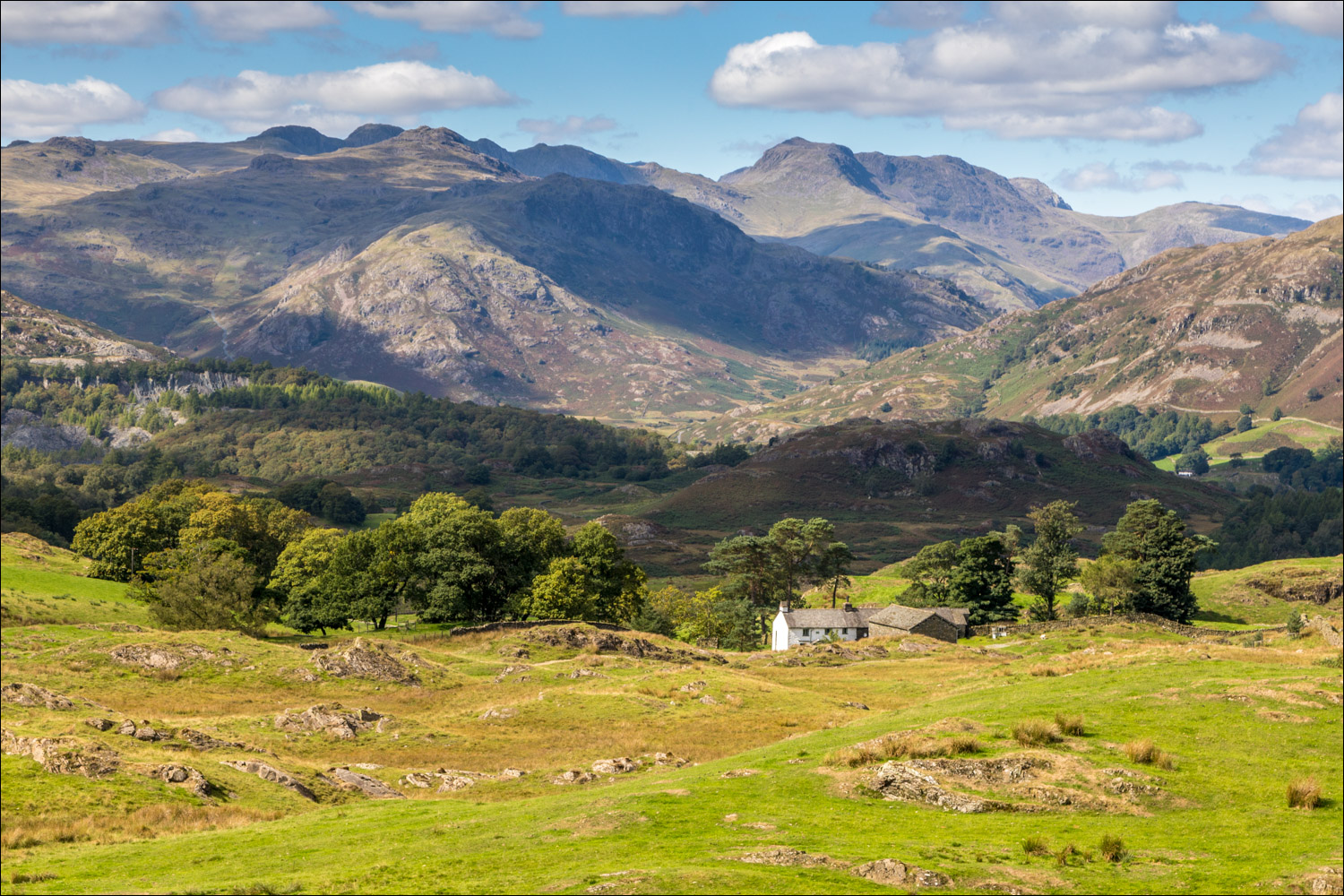
We descend beside the dry stone wall in the direction of Low Arnside mid picture

Looking across to our original path, with a glimpse of Tarn Hows, and Coniston Water in the distance

We continue to descend beside the dry stone wall

Low Arnside ahead...


Having passed by the farm we walk towards Hollin Bank

The path contours around the bank...


Having crossed the A593 we follow the lane towards Low Oxen Fell, in order to avoid the traffic

Wetherlam, Pike o'Blisco and Bowfell seen from the lane

We pass by this attractive old cottage

The lane takes us back to the A593 but we're able to avoid tarmac by following this path through the woodland, with the road to our left...


Yew Tree Tarn, formed when the local landowner dammed Yewdale Beck in the 1930...


View from the dam

We arrive back at Glen Mary car park to end a wonderful walk

Later that day, a welcome garden visitor
