
Route: Rye
Area: East Sussex
Date of walk: 11th June 2025
Walkers: Andrew and Gilly
Distance: 2.0 miles
Ascent: 150 feet
Weather: Sunny and warm
Rye is a medieval hilltop town which overlooks Romney Marsh and the River Romney. The old part of the town has been well preserved, is mostly traffic free, and contains numerous cobbled alleys and ancient buildings. It’s a fascinating place to wander around. Although I’ve included a route map, it’s just for the purposes of recording today’s walk. It’s best to wander wherever your fancy takes you
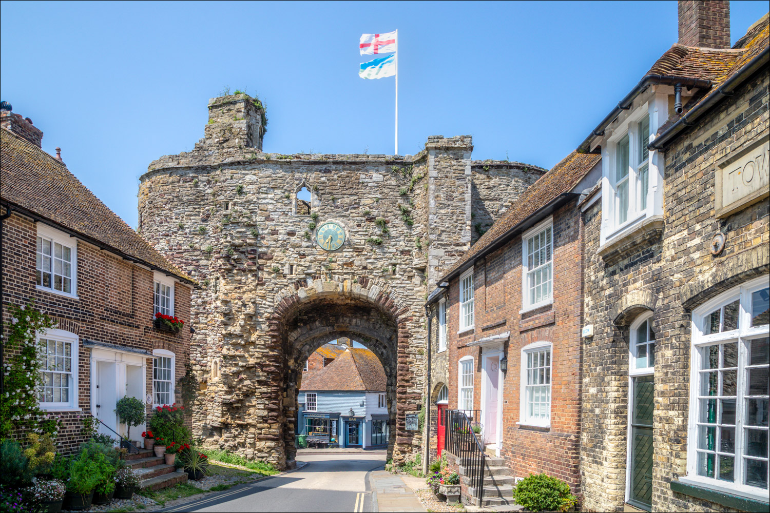
We parked in one of the public car parks on the edge of the old town and walked up to the old fortified gateway of Landgate built in 1329. From there we sought out Mermaid Street, one of the ‘must see’ parts of Rye, a cobbled street lined with old houses with quirky names, including ‘The House Opposite’ and ‘House with Two Front Doors’
As we passed by the Parish Church of Rye, dedicated to St Mary the Virgin, we decided to visit the interior. Sometimes called the “cathedral of East Sussex”, the church has dominated the hill on which the citadel is built for over 900 years and its position offers extensive views from the top of the tower. Having paid the fee, we climbed up the steep and very narrow stairs (anyone on the plump side or having claustrophobia is advised to avoid this detour). The views from the tower were wonderful, looking over the ancient rooftops of Rye and out to Rye Harbour Nature Reserve (the subject of our next walk), Camber Sands and Winchelsea
After leaving St Mary’s Church we walked to nearby Rye Castle and the Ypres Tower, a Scheduled Monument built in the 13th Century. From here we wandered back to the start of a lovely stroll through the old streets of Rye. Anyone visiting Rye is recommended to continue to nearby Rye Harbour Nature Reserve – see my next walk for details
For other walks here, visit my Find Walks page and enter the name in the ‘Search site’ box
Click on the icon below for the route map (subscribers to OS Maps can view detailed maps of the route, visualise it in aerial 3D, and download the GPX file. Non-subscribers will see a base map)

Scroll down – or click on any photo to enlarge it and you can then view as a slideshow

The start of today's through the streets of Rye, looking back to The Landgate, the only surviving one of four original fortified entrances to Rye. It dates from 1329 in the early years of the reign of King Edward III

We walk along The Mint, home to several listed buildings

The streets are lined with interesting and quirky shops, a welcome change from many high streets these days...


Old houses of Rye...


We walk up Mermaid Street, the most iconic of Rye's old streets


The Mermaid Inn - its cellars date from 1156 and the building was rebuilt in 1420 after Rye was burnt to the ground by French Raiders in 1377

Looking back down Mermaid Street

We pass by Lamb House - Henry James lived here 1898-1916

The Old Vicarage

St Mary's Church - in 1742 the butcher John Breeds accidentally murdered Allen Grebell in the churchyard instead of the mayor he really intended to kill. He was hanged and gibbeted. His skull was brought to the town hall and remains there. Both are still said to haunt the churchyard

We enter the church and climb up the Tower, consisting of a spiral staircase, a narrow passageway (not for the claustrophobic), some narrow steps and a couple of ladders. This is the Ringing Chamber

Views from the Tower of St Mary's Church...

Rye Castle and the River Rother, with Dungeness in the far distance

Looking down to the Old Vicarage

Lion Street and the Town Hall below

Rye Hill on the left

Back at ground level, more old buildings of Rye - Fletcher's House...

...the Runcible Spoon...

...and Rye Castle, also known as Ypres Tower, built in the 13th or 14th centuries

The Gun Garden at Rye Castle with a battery of cannons facing out to sea

We wander around Church Square, which surrounds St Mary's Church...


We walk along Trader's Passage and then retrace our steps to the end of a fascinating town walk, steeped in history
Follow the link for more walks in East Sussex (6)
