
Route: Hackness
Area: North Yorkshire
Date of walk: 9th October 2016
Walkers: Andrew and Gilly
Distance: 5.5 miles
Weather: Sunny intervals
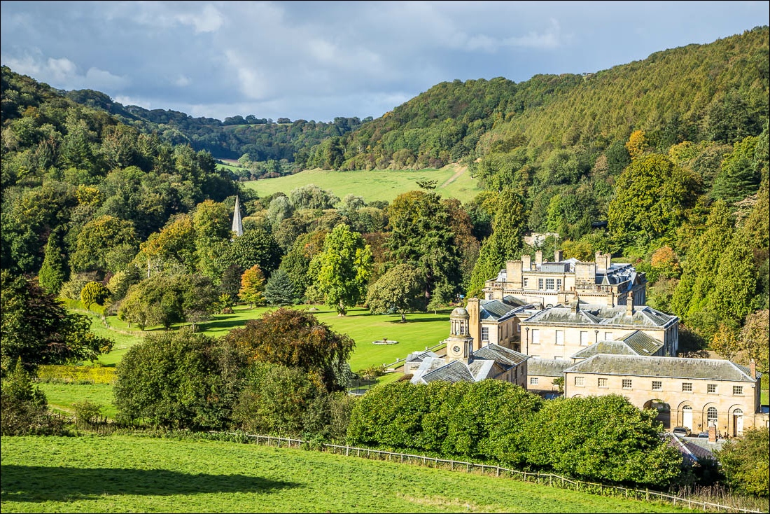
We started today’s walk from the village hall in Hackness and walked along the road out of the village for a short distance, crossing the road bridge over the River Derwent, and then climbing up a path behind Mill Farm. The path contours round the hillside, giving beautiful views over Hackness Hall and St Peter’s Church along the way
After descending to the road we walked past Hackness Hall, St Peter’s Church and the village school and then forked off right along the lane to Lowdales. Although this is a public road I’ve hardly ever seen a car along here as it’s a dead end and only serves a few houses. It’s a delightful lane to walk along. After a while we arrived at the footbridge which we’ve sometimes had to use when the road is flooded, and here we turned off to climb up a path through the woods to Broxa Rigg
Just before Broxa, and near the top of the rigg, we joined a path which hugs the side of fields beside Hackness Head Wood. Buzzards often soar overhead here and we saw a pair of them today looking for their lunchtime snack
Broxa Rigg is one of the tabular hills that are a feature of the area, though the views from it are limited by the adjacent woodland, and the path never gets quite high enough to see the surrounding countryside. Never mind, it’s still a worthwhile section of the walk
The start of the descent back to Hackness can easily be missed. It’s at the point where Hackness Head Wood on the left and Chapman Banks Wood on the right start to converge on each other. Look for a gate leading to a track down Chapman Banks Wood and from here it’s plain sailing back down to the village and the conclusion of a great little walk
For other walks here, visit my Find Walks page and enter the name in the ‘Search site’ box
Click on the icon below for the route map (subscribers to OS Maps can view detailed maps of the route, visualise it in aerial 3D, and download the GPX file. Non-subscribers will see a base map)

Scroll down – or click on any photo to enlarge it and you can then view as a slideshow

On Broxa Rigg, looking back towards Broxa


The road ahead is sometimes flooded, but we turn off to the left here and as we do so we notice some new road signage…


Having left the lane we climb up to Broxa Rigg - shorts would be a bad sartorial choice here as tall stinging nettles abound

We turn off the road beyond the bridge to follow the lane into Lowdales

Walking beside Hackness Head Wood…


Rainclouds behind, but luckily they didn’t catch up with us

A large herd of cattle (some with alarmingly sharp horns) were blocking my route here and I had to commit an act of trespass in order to avoid them

Before Hackness Head I walk over to the other side of Broxa Rigg to locate the path back down to the village..

…here it is


Back to the start - the war memorial at the village hall

Not quite the end of the walk for us, as we were staying in Hackness…

…at Derwent View


The start of the walk - the war memorial by Hackness Village Hall

Leaving Hackness

Mill Farm and its beautifully maintained garden

Beyond Mill Farm we leave the road to pass through this gate

Looking back over Mill Farm to Hackness

Old barns on the other side of the River Derwent

Wrench Green

Coomb Slack

We follow a wonderful path above Hackness Hall

Hackness Head Wood and Keeper’s Cottage

Birdwatchers’ Car Park Forge Valley, on the way to Hackness - Marsh Tit or Willow Tit? So alike that they were once thought to be the same species

We descend to the road, unseen from here


Timeless views over Hackness Hall and St Peter’s Church…


We walk along the road back into Hackness…

…and past the entrance to Hackness Hall


A small detour to the churchyard at St Peter’s…

… to say hello to Auntie Marjorie, who lived in Hackness and loved this place

