
Route: Saligo Bay
Area: The Rhinns of Islay
Date of walk: 22nd March 2022
Walkers: Andrew and Gilly
Distance: 4.7 miles
Ascent: 500 feet
Weather: sunny but hazy
The Rhinns of Islay is a peninsula on the west of Islay which is designated as a special protection area and is home to some rare birdlife. The area also boasts some beautiful beaches, some of them around Saligo Bay, the subject of today’s walk
We parked by an access gate near the Saligo River. There is only space for about 5 cars here, so in summer it may be best to arrive early. As it was, there was no-one else here, and during the course of the three hour walk we didn’t see another soul
After passing through the access gate, we left the obvious track and headed directly towards the dunes and the beach. The path is not obvious, but the line of travel isn’t in doubt – just head for the sea. We soon arrived at Traigh Fleisgein Mhor, a wonderful sandy beach studded with rocks, which we followed north along the coast. Tide times dictate the exact route and we simply kept as near to the sea as possible. The next beach along the coast is Traigh Fleisgein Bheag, another wonderful spot where we could happily have spent the rest of the day. Note that swimming anywhere along this coastline should not be contemplated on account of the strong rip tides
At the end of the beach we made a short detour to two simple gravestones, one inscribed with the date 1818. It’s thought that these belong to drowned sailors. This marked the start of the return leg, which was over slightly higher ground with good views back over the beaches, though it would be no hardship to simply retrace your steps
We arrived back at the parking space from where we set out on the second section of the walk. We walked along the road for a short distance, crossing the small bridge over the River Saligo, and just beyond a cottage on the right we left the road to descend towards the sea. This area of the coastline was more rugged and the going was boggier and rougher than the first section. We kept as close to the coast as possible, but jagged rocks made it impossible to descend to the shore. Some of the rock formations were spectacular. We eventually arrived at a fence which encloses a deep inlet containing arches which we found hard to identify, possibly on account of the high tide. This marked the far point of the walk and from here we followed a grassy and sometimes boggy track below the inland cliffs which took us back to the start of a wonderful walk
Click on the icon below for the route map (subscribers to OS Maps can view detailed maps of the route, visualise it in aerial 3D, and download the GPX file. Non-subscribers will see a base map).

Scroll down – or click on any photo to enlarge it and you can then view as a slideshow

It's a short stroll from the car park at Saligo to the dunes above Traigh Fleisgein Mhor

We descend to the deserted beach and turn right along it...


Rough seas...


We carry on to the end of Traigh Fleisgein Mhor and make our way along the coast, keeping as near to the sea as possible. The exact route will depend on tide times


Approaching the next beach, Traigh Fleisgein Bheag


We climb above the beach to the far end of the walk

We seek out a couple of small gravestones which we'd read about

One of the stones is engraved with the date 1818, and it's thought that they belong to two drowned sailors, as mariners were often buried looking out to sea, rather than being interred in the local graveyard

We retrace our steps to Traigh Fleisgein Bheag and from here follow a slightly higher path back to Saligo

After arriving back at the car park (this is a figure of eight walk), we set off on the second leg of the walk. We cross the bridge over the River Saligo and will turn right just beyond the cottage ahead

We pass through the gate signed 'To The Arches'

The end of the journey for the River Saligo

Looking back along Saligo Bay

This part of the route was rougher than the first part. There are no sandy beaches and access to the sea is very limited

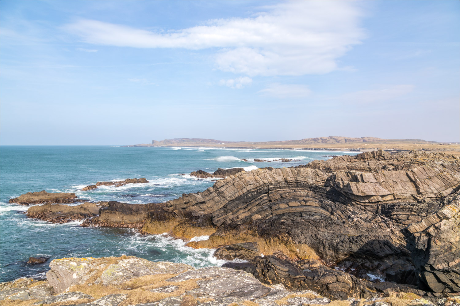
I climbed a small grassy promontory and was amazed to see this rock formation, which I'd not read about in other walk deions

Thanks to Geology of Islay I can now identify the feature as 'folded metagreywackes'


Views back along the coast as we follow the path to the natural arches


The arches are inside this deep cleft, which is fenced off, and we couldn't get near enough to identify them, despite continuing to the cliff edge ahead. This would have been a slight anti-climax but for the wonderful and unexpected sight of the' folded metagreywackes'

We retrace our steps for a short distance and then head inland for the return leg

We follow a sometimes boggy track beneath the inland cliffs (retracing your steps along the coastal path may be a better option)


We arrive back at Saligo and climb back above Traigh Fleisgein Mhor to the end of a wonderful walk
Follow the link for more walks in Scotland (44)
