
Route: Puez-Odle Altopiano
Area: Alta Badia, Dolomites, Italy
Date of walk: 16th June 2018
Walkers: Andrew, Gilly and James
Distance: 12.5 miles
Ascent: 2,200 feet
Weather: Sunshine and blue skies
Today’s first walk in the Dolomites wasn’t the one that we’d planned, but it turned out to be one of the most memorable of our lives. Our intention had been to follow a route beyond the Gardena Pass, but as chance would have it a major cycle event was taking place and the road beyond the pass was closed until 10.30am. We had no choice but to park on the roadside just below the head of the pass, and we decided to go for a short walk to the signposted ‘Jimmy’s Hut’
As we were plodding uphill we realised that another walk on our to do list passed by Jimmy’s Hut, and so we decided to follow that instead – it turned out to be a good decision. Anyone following this walk is recommended to start from Selva and catch the cable car up to the Gardena Pass, or to start from the head of the pass, as our parking space was a roadside one and the start was improvised. Beyond the hut we climbed steadily uphill to reach a thrilling vantage point at Passo Crespeina, where a vast and awesome landscape revealed itself, including the undulating Puez-Odle Altopiano (Puez plateau). In the far distance we could make out the Rifugio Puez, which was on our route, though we wondered how we would manage to get there safely through such dramatic terrain.
We followed a path which took us through partially melted snowfields, passing by Lago di Crespeina as we did so. I’ll let the photos tell the story of the long journey to the Rifugio, but eventually we arrived there and some ice cold beer went down a treat. It was now time to descend into the valley, and the initial section was very intimidating – it was hard to envisage how there could be a safe passage down to the valley beside the huge rock faces and seemingly huge drops. As it turned out, the path was steep and loose at times but perfectly safe thanks to the innumerable zigzags which took the sting out of the gradient
We eventually reached some pine and larch woodland and the gradient eased. Further along, we reached the stunningly beautiful pasture of Pra da Rie – every step along the lovely path here was a pleasure. Lower down, we arrived in Selva and from here we took the gondola car, which whisked us back up to the Gardena Pass, ascending nearly 2,000 feet in a matter of minutes (the cable car route is shown on the Maps Page as part of the overall route, and I’ve deducted the distance and height gain from the figures shown above). It just remained to retrace our steps back to the car. It had been a long and tiring 6.5 hour walk, with many ups and downs and twists and turns, but the scenery had been spectacular throughout. Although it hadn’t been the walk we’d planned, the day couldn’t have turned out better
Click on the icon below for the route map
![]()
Scroll down – or click on any photo to enlarge it and you can then view as a slideshow

Our first morning in the Dolomites, and the view from our room at the excellent and highly recomended Sporthotel Panorama in Corvara - we didn't know it at the time, but events would lead us to walking behind the mountains in the photo

After driving up the Passo Gardena from the hotel, our progress was thwarted by a bike race which meant that the road was closed, so we left the car near the top of the pass to go for a stroll, intending to return once the road was re-opened

Looking back along the path

As we gained height, we decided to make a virtue of necessity and plot a new route. In conditions like this, it seemed to be a waste of time to await the re-opening of the Passo Gardena

We duly consulted our Cicerone guide, and Plan B was adopted - we'd hike up into the mountains ahead

Rifugio Jimmi, or Jimmy's Hut - here we'd have the opportunity to check our plan. Our new route would take us to the gap above the hut

Looking back to the spectacular Sella group above Passo Gardena....

After a brief stop at Jimmy's Hut we start the steep climb up to the gap in the rocks

A view back to Sassolungo as we arrive at the gap we'd seen from below

Looking back down the path to the Sella group

We enter a silent inner valley, surrounded by bizarre knobbly rock pinnacles

Another view back along our path

Gilly and James study the route ahead - we're aiming for the Passo Cir

We follow the zig zag path leading up to the Passo Cir...


Looking back down our path

Having reached the Passo Cir, there's a short descent as we head for Passo Crespeina, top right of picture

We follow a path across the barren mountain side, passing over several remaining snowfields

Passo Crespeina ahead, in the centre of the picture

A view back along our path...

...and again from the Passo Crespeina at 8,300 feet

We follow a twisting route towards the Puez plateau

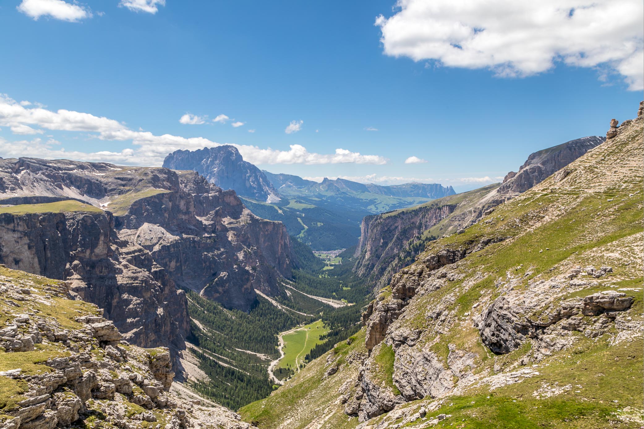
The Puez plateau, and one of the unusual cone shaped hills arising from it

We pass above Lago di Crespeina

We traverse the rocks towards another pass, Forcella de Ciampac

View from Forcella de Ciampac

We pass through a short rock corridor

The path continues at high level above the head of the Vallunga valley below to our left

View along the Vallunga

Rifugio Puez comes into view

Vallunga again - the valley will be on our return route

Well earned refreshments at Rifugio Puez

We now have to descend into Vallunga, and the path appears to plunge into the abyss

'You go first'

My turn to follow

The path is steep at times but not as bad as feared, and instead of descending directly into the valley it traverses the mountainside

Passo Crespeina up there, and we're now following a path below the one we'd taken earlier

Vallunga


The gradient eases a little as we reach some pine trees

Our descent path had taken us along the foot of the cliffs above

We finally arrive at the valley floor and walk along a white rubble gully beside a stream

We follow a path through pine and larch trees, which gradually thin out as we walk further along the valley...


We reach the beautiful pasture Pra da Ri

Looking back to the Ciastel de Chedul

We pass by St Sylvester's Chapel

Approaching the end of the valley

From the outskirts of Selva, looking back to Steviola, one of the guardians of the entrance to Vallunga

We arrive in Selva and find our way to the departure station of the gondola, which will transport us back up to the start at Passo Gardena

Looking back down to Selva through the window of the gondola

After an enjoyable 15 minute ride we arrive at Dantercepies

It just remains to stroll down to Passo Gardena below to end a thrilling and varied walk which will live forever in our memories
Follow the link for more walks in Italy (23)
