
Route: Lingmoor Fell
Area: Southern Lake District
Date of walk: 5th February 2020
Walkers: Andrew
Distance: 8.5 miles
Ascent: 1,900 feet
Weather: mixture of grey skies and some bright spells
It’s been almost a year since I visited Lingmoor Fell. The fell has two main attractions – a rollercoaster dry stone wall which runs along its undulating ridge, and the views of the Langdale Pikes. This is probably the best place in the district from which to see them
As on the last occasion, I parked in the National Trust car park in Elterwater and crossed the road bridge over Great Langdale Beck, heading towards the slate quarry. Lingmoor Fell is renowned for its beautiful green slate and has been extensively mined for it – evidence of this is abundant on the early section of the walk
I followed an old mining track for a while before leaving it to climb up the open fellside to gain the summit ridge. Just below the ridge, the walk almost came to a premature end at a tall metal gate. In attempting to lift Bonnie, our retriever, over the gate she fell, let out a yelp and lay down with her leg in the air. At first I thought she’d broken it but to my huge relief she got up. After limping around for a minute she was back to her old self, and walking normally. It was a worrying few moments
I continued to the ridge and followed its undulating course to the summit cairn. Up to this point the light was very uninspiring – a flat uniform grey – so I didn’t linger and started out on the descent. Navigation is simple and just involves keeping the dry stone wall beside you. Some of the descent sections are quite steep, and include a rock groove which has been polished to a fine sheen by countless bottoms shuffling down it, but there are no difficulties
Eventually I encountered the rock wall of Side Pike, the top of which is accessible via a narrow path to the left, but this does not provide a way off the fell, and so just before reaching it I descended in the direction of Little Langdale. The light had improved by now and Great Langdale and the Langdale Pikes were looking superb as I contoured around the fellside. Having reached valley level it was an easy walk back into Elterwater along Great Langdale, where I passed through fields and then woodland beside Great Langdale Beck
For other walks here, visit my Find Walks page and enter the name in the ‘Search site’ box
Click on the icon below for the route map (subscribers to OS Maps can view detailed maps of the route, visualise it in aerial 3D, and download the GPX file. Non-subscribers will see a base map)

Scroll down – or click on any photo to enlarge it and you can then view as a slideshow

Elterwater at the start of today's walk

I cross the bridge over Great Langdale Beck and turn right at the white house 'Bridge End'

I pass by Chapel Stile on the far side of the beck

I pass through a slate quarry, with the Langdale Pikes in the background

I leave the lane here to start the climb up to Lingmoor Fell

Looking back to Chapel Stile on the far side of Great Langdale

I follow this old mining track and branch off a little further along - the fork is well signed

Chapel Stile again as I climb towards the ridge of Lingmoor Fell

I arrive on the ridge, here looking back to Elter Water and Windermere

Wetherlam beyond a stone memorial bench

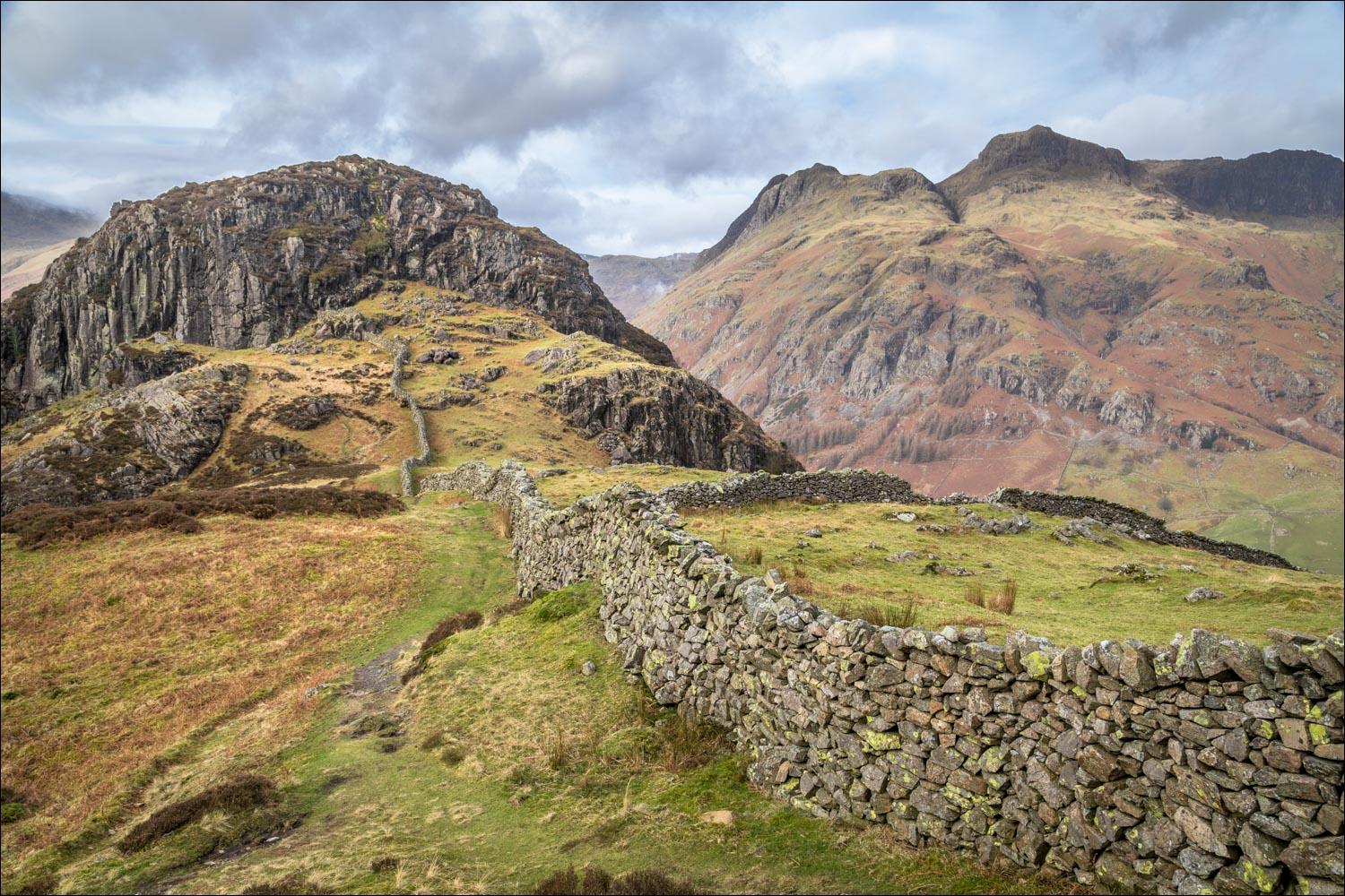
The first of many sightings of the Langdale Pikes as I make my way along the undulating ridge line. Navigation is simple - just follow the dry stone wall

Summit of Lingmoor Fell ahead

Summit cairn on Lingmoor Fell, looking towards Pike o'Blisco. I didn't linger here as the light was very poor, though would improve later on

I descend beside the dry stone wall, with ever improving views of the Langdale Pikes ahead

Blea Tarn below at the foot of Pike o'Blisco

The descent of the ridge continues as far as Side Pike below - this is out of bounds to ordinary walkers and has to be bypassed

Side Pike and the Langdale Pikes

The Langdale Pikes - L to R: Pike o' Stickle, Loft Crag, Thorn Crag, Harrison Stickle and Pavey Ark

Blea Tarn below

Great Langdale below

An improvement in the light as I approach the imposing face of Side Pike...


Harrison Stickle, the highest of the Langdale Pikes and the most dominant visually

At the foot of Side Pike I turn left to descend in the direction of Little Langdale

Blea Tarn

I follow a narrow path to the right of Side Gates, the narrow lane which links Little Langdale and Great Langdale

Looking across to Blea Tarn

A heavenly section of the walk as I arrive at the head of Great Langdale, here looking towards The Band which leads up to Bowfell

Mickleden

Allen Crags at the head of Mickleden

The Band again, with Oxendale left and Mickleden right

Crinkle Crags above Oxendale

Mickleden as I continue to descend towards Great Langdale...


Looking across to the Langdale Pikes as I head east along Great Langdale

Great Langdale...


I pass by Side House

Looking back to the photogenic Langdale Pikes


At Oak Howe I continue straight ahead, although an alternative path lies to the right

The remainder of the walk is beside Great Langdale Beck, here looking back to the Langdale Pikes shortly before I arrive back in Elterwater
