
Route: Latrigg
Area: Northern Lake District
Date of walk: 4th December 2015
Walkers: Andrew and Gilly
Distance: 6.2 miles
Weather: Mostly overcast and dull, light rain, very windy on top
The weather today was poor, but in comparison with the torrential rain and horrendous gales which have prevailed for most of the last month it felt like a good day for a walk. Humble Latrigg would fit the bill nicely
We parked as usual on the roadside at Briar Rigg and walked up Spooney Green Lane, crossing the bridge over the busy A66 along the way. After a while we joined the path leading to the top of Latrigg. The climbing was easy throughout
The views over Keswick and Derwent Water from the top of the fell were as superlative as ever, though it’s a shame that the weather was rather uninspiring. The wind was ferocious and it was hard keeping the camera steady
We then followed the ridge of the fell in an easterly direction down to Brundholme where we started the return leg along the old railway line, which crosses back and forth over the River Greta before ending in Keswick. This is a lovely walk, whatever the weather
For other walks here, visit my Find Walks page and enter the name in the ‘Search site’ box
Click on the icon below for the route map (subscribers to OS Maps can view detailed maps of the route, visualise it in aerial 3D, and download the GPX file. Non-subscribers will see a base map)

Scroll down – or click on any photo to enlarge it and you can then view as a slideshow

The day before the walk, red squirrel in the rain


The next day and the start of the walk - Latrigg ahead

We cross the footbridge over the A66

Further along Spooney Green Lane

Looking back to Derwent Water and the North West Fells

Bassenthwaite


Keswick, Derwent Water and Catbells

The path continues up through woodland…

…before emerging onto open fellside

A zigzag section takes us in the direction of Skiddaw

We leave the main path to climb up the slopes of Latrigg


We follow the inviting path


A hint of things to come

Looking back towards Skiddaw

Progress was quite tortuous in the face of a very strong wind

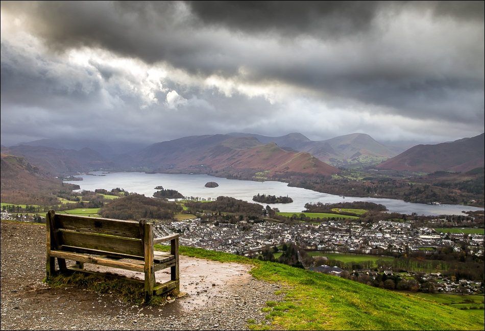
Viewpoint near the summit of Latrigg, looking over Keswick and Derwent Water, but no place for a picnic today

Bassenthwaite Lake

Looking back to Skiddaw Little Man

Looking back along the path

We follow the path down the summit ridge in the direction of Blencathra


A windswept old pine tree

Great Mell Fell on the distance

We descend towards Brundholme


The lower slopes of Blease Fell, leading up to Blencathra

The River Greta below - we will turn right when we reach it

Looking along the iron railway bridge - little did we know that it would be washed away the next day by devastating floods

We follow the old railway line with the River Greta on our left

The Greta was already running fast - next day’s floods would cause it to burst its banks and wreak havoc in Keswick


Start of the boardwalk section near Keswick

We pass back under the A66

We arrive at the old railway station and from here it’s a short walk back to the start
