
Route: Justadtind
Area: Norway, Lofoten Islands
Date of walk: 29th July 2017
Walkers: Andrew and Gilly
Distance: 8.2 miles
Ascent: 2,600 feet
Weather: Sunny and very hot
For the third day running we were greeted by sun and blue skies and, tempted by the prospect of more big views, we decided to climb Justadtind. The mountain stands at approximately 2,500 feet and is one of the highest points on Vestvågøy, affording panoramic views around the island
We parked our rented car in the car park ‘Hagstua’ on the 815 road to Stamsund. After following a stony track for a short distance we started the long climb up the mountain. The retrospective views were fabulous, even during the early stages of the ascent, and there was a thrilling moment about half way up when a white-tailed eagle flew overhead (needless to say I’d left the telephoto lens behind)
The climb was mostly at a gentle gradient, although the higher we climbed the steeper and rockier it became – and there was one short scramble up a rock chimney, but this was very easy. The main difficulty on this walk was the extreme heat, very surprising considering that we were in the Arctic Circle. The temperature was around 22c, and even though we’d brought as much water as we could comfortably carry it wasn’t enough
So it was that we emerged huffing and puffing on the summit of Justadtind – and what a special moment this was as we were greeted by a magnificent panorama of countless mountains, lakes, islands and the sea. We could even see mainland Norway in the far distance. It was a privilege to be up here in such conditions. All good things must come to an end and reluctantly we started the long descent and retraced our steps back to the start of a tiring but wonderful walk
Click on the icon below for the route map
![]()
Scroll down – or click on any photo to enlarge it and you can then view as a slideshow

We join a gravelled track leading away from the Hagstua car park

The first few minutes of the walk are through woodland

But it's not long before big views start to appear as we look back

We pass by several small tarns

The jagged peak of Justadtind comes into view...

The terrain gradually becomes rockier as we gain height


Looking across to Storfjorden

A white-tailed eagle soars overhead and I regret not packing the long lens

We reach an area known as Tjørnan, where there are several lakes and tarns...


More retrospective views as we continue the long climb


Justadtind ahead


We reach a col called Moshumpan

We can just make out the coast of mainland Norway in the distance

Justadtind from the col

The final section to the summit, which is further away than appears from the photo

Looking back over a small tarn

Gilly (bottom right of picture) starts out on the rocky but not difficult climb to the summit

Looking back down the path

Ever improving views as we gain height...


Summit of Justadtind ahead


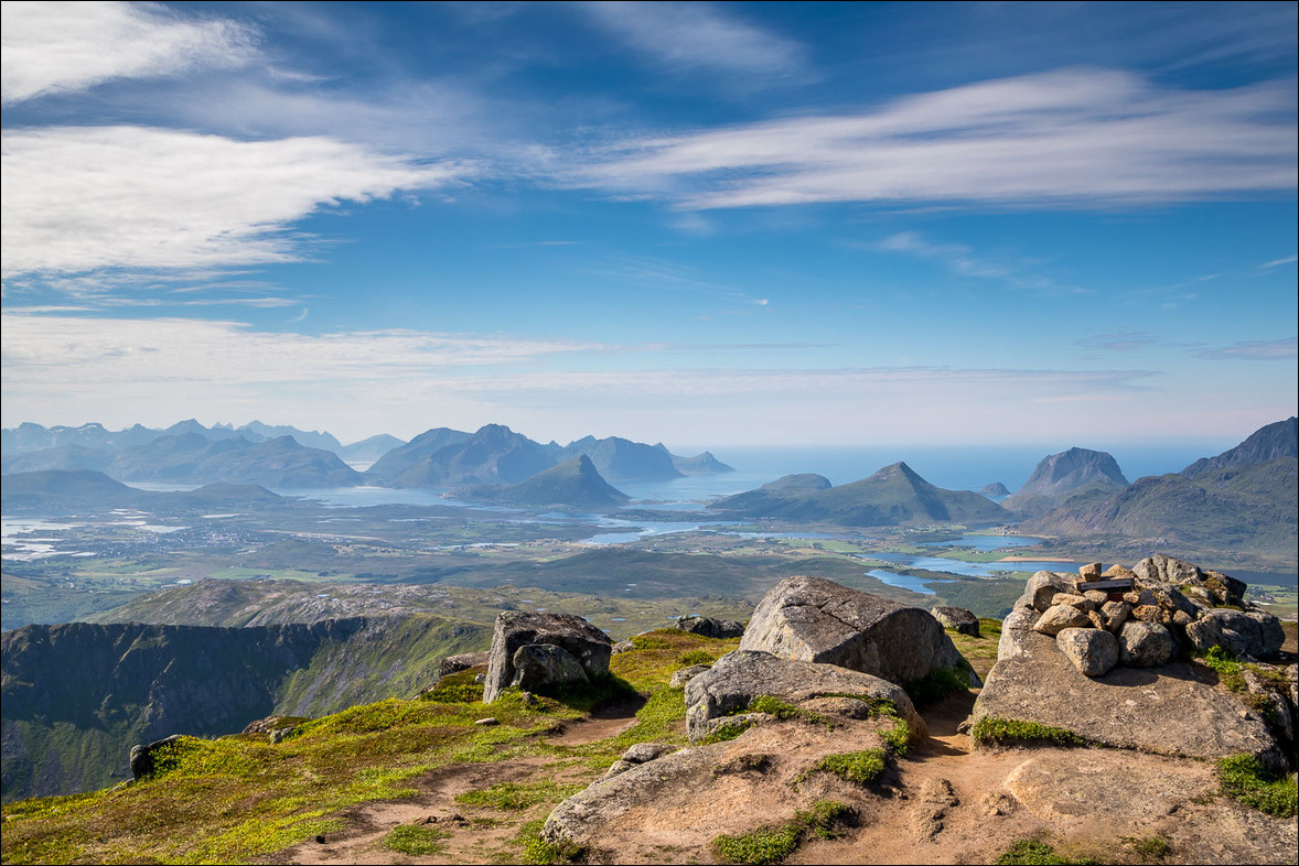
Incredible views from the summit of Justadtind

The view east over Rolvsfjorden

The summit cairn

Yours truly

Views over Vestvågøy...

We retrace our steps back to the start...

...and enjoy the wonderful views once more

Back at the rorbu, we treat ourselves to two big Mack's
