
Route: The High Stile Range
Area: Western Lake District
Date of walk: 9th August 2018
Walkers: Andrew
Distance: 8.5 miles
Ascent: 2,800 feet
Weather: Sunny, with good visibility and a cool breeze on the tops
The High Stile Range is one of the classic lakeland walks, visiting the 3 high fells which tower over the western shore of Buttermere – Red Pike, High Stile and High Crag in order of appearance
It was a glorious morning as I parked in the National Trust car park outside Buttermere village and walked past the foot of the lake, leaving the lakeshore path to start the climb up to Red Pike. A rocky staircase took me much of the way but after reaching Bleaberry Tarn the going got tougher and the final pull to the summit of Red Pike was quite hard – very steep and loose underfoot. Just below the summit there’s a particularly steep section up a narrow gully where hands on rock were needed. Anyone emerging from this gully is likely to have their fingers stained red, not with blood, but from the syenite in the rock and subsoil on Red Pike (hence the name)
The views from Red Pike were fantastic and after admiring them for a while I started the walk along the ridge, visiting the highest point High Stile at 2,644 feet and then High Crag
Next came the very steep and knee-jarring descent down Gamlin End, which is seemingly never ending. This has been made easier lower down by the addition of a well pitched rock path. Just before Seat I took a path off to the left (which is easily missed), and this provides a shortcut down to Scarth Gap Pass, which in turn leads down to the shore of Buttermere. I followed the lakeshore path through Burtness Wood and back to the start of a fantastic walk – one of lakeland’s finest – which was seen at its best in today’s conditions
For other walks here, visit my Find Walks page and enter the name in the ‘Search site’ box
Click on the icon below for the route map (subscribers to OS Maps can view detailed maps of the route, visualise it in aerial 3D, and download the GPX file. Non-subscribers will see a base map)

Scroll down – or click on any photo to enlarge it and you can then view as a slideshow

On the way to Buttermere, a roadside photo across Crummock Water looking towards today's objective - the High Stile Range. Red Pike is first on the list, to the right of the picture

After leaving the National Trust car park at Long How I pass by Cragg House Farm Cottages, with High Stile in the background

I follow the path to the foot of Buttermere, with the High Stile Range to the right...


I arrive at the foot of the lake

Fleetwith Pike at the head of Buttermere

The old bridge over Buttermere Dubs collapsed a few weeks ago when the main beam failed. The bridge has been rebuilt elsewhere using the same materials and will be deposited back on the site in its entirety. I cross the temporary bridge

I branch off the lakeshore path to follow the rocky staircase through Burtness Wood

Above the tree line now, and a view across Buttermere to the Honister Pass and Fleetwith Pike

Looking back to Buttermere village

Crummock Water

Buttermere village and Newlands Pass

A view back along the path, with High Snockrigg and Robinson beyond Buttermere

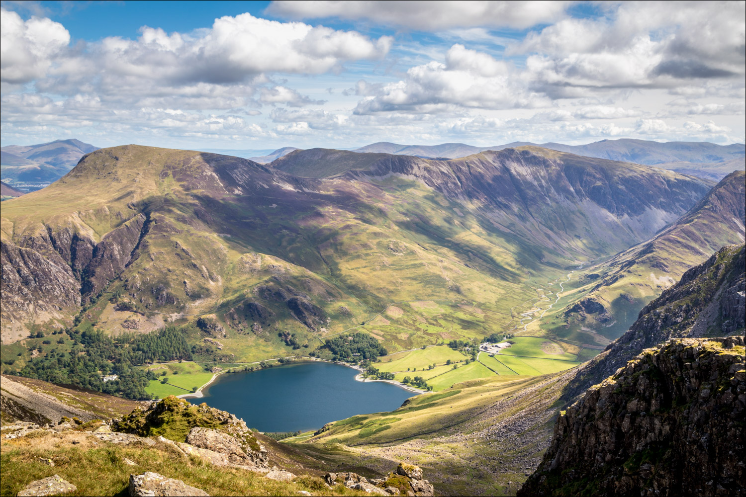
Red Pike up on the right as I arrive at Bleaberry Tarn

I walk round the shore of the tarn and follow the path towards Red Pike

The route will take me along the ridge above to High Stile on the left

Looking back down the path to Bleaberry Tarn

Crummock Water, a glimpse of Loweswater on the left, and the Solway Firth and Scotland in the distance

From the summit of Red Pike, Dodd in the foreground, and Derwent Water in the middle of the photo

Ennerdale and the Solway Firth beyond

Start of the thrilling ridge leading to High Stile, the highest fell on the round at 2,644 feet

Looking down to Bleaberry Tarn as I walk along the ridge

High Stile ahead

Buttermere village below. Knott Rigg and Ard Crags, the subject of yesterday's walk, are in the centre of the photo

Ennerdale from High Stile

Crummock Water, and Scotland in the distance

Bleaberry Tarn below, and the path I'd followed earlier up to Red Pike

Fleetwith Pike and the Honister Pass from High Stile

I follow the ridge to the next and final fell - High Crag

The head of Buttermere and the Honister Pass as I descend from High Stile

High Crag, the final fell on today's walk

Pillar on the far side of Ennerdale, and the Scafells in the distance

Looking down one of several steep gullies to the head of Buttermere

I follow a line of old metal fence posts along the ridge

The path to High Crag

A view back to High Stile

Summit of High Crag, looking towards Great Gable

Dramatic light on Haystacks and Seat at the start of the descent from High Crag

Ennerdale from High Crag

Great Gable at the head of Ennerdale

Head of Buttermere left and Fleetwith Pike right

The very steep descent of Gamlin End to Seat, with Haystacks beyond

Haystacks

Just before Seat I branch off the main path to join Scarth Gap Pass (the junction is easily missed)

I descend beside an old dry stone wall

Having joined Scarth Gap Pass, I follow the path down to Buttermere...


Head of Buttermere below

I arrive at the lakeshore path, one which I've followed many times before

Looking back to the boathouse at the head of the lake

Another view back to the boathouse, with Fleetwith Pike towering over it

I follow the lakeshore path

Looking back

I arrive back at the foot of Buttermere, here looking towards Fleetwith Pike, and retrace my steps back to the start of a wonderful walk

Red squirrel in the rain the following morning
