
Route: Haystacks
Area: Western Lake District
Date of walk: 24th November 2023
Walkers: Andrew and Phil
Distance: 5.6 miles
Ascent: 1,900 feet
Weather: Mostly sunny, bitterly cold on the tops
Haystacks was the favourite fell of Alfred Wainwright and it’s mine too – it’s a fascinating place and there’s always something new to see. We parked in the car park at Gatesgarth Farm (note the parking fee is currently £4, cash only). We walked through the farm and crossed Peggy’s Bridge at the head of Buttermere. The climbing starts below a small triangular shaped copse, and from here we followed the easy path up to Scarth Gap
Beyond Scarth Gap the going gets much steeper and rockier, and there are are five or six scrambly sections up rock steps where hands are needed. There are no dangers and it’s an enjoyable clamber. A final steep section brought us to the summit. We both felt a sense of achievement – Phil has happy memories of this place, but hasn’t been here for many years and I was relieved to be back again having undergone a knee replacement in February. It was wonderful to be here after having doubts that I’d ever see this place again. The summit area is a fascinating place full of bumps and hollows, with different views from each, though the wind chill today made conditions bitterly cold so we didn’t linger for long
A direct descent from the summit is impossible and it’s necessary to walk across some complicated knobbly terrain – Haystacks is a bad place to be if lost in mist. As Wainwright puts it ‘the only advice that can be given to a novice lost on Haystacks in mist is that he should kneel down and pray for safe deliverance’. There was no mist today and so we aimed for the contradiction in terms which is Innominate Tarn and continued to follow the path in the direction of Dubs Quarry. Eventually we arrived at the first of the two possible descent paths to Warnscale Bottom, and chose this for the descent. The alternative path is easier but a little further on and follows the far side of Warnscale Beck. Both paths meet up at valley level, and both provide a safe way down, with lovely views ahead along Warnscale Bottom and Buttermere for most of the way
It was another wonderful visit to this special place
For other walks here, visit my Find Walks page and enter the name in the ‘Search site’ box
Click on the icon below for the route map (subscribers to OS Maps can view detailed maps of the route, visualise it in aerial 3D, and download the GPX file. Non-subscribers will see a base map)

Scroll down – or click on any photo to enlarge it and you can then view as a slideshow

Gatesgarth Farm at the start of today's walk

We aim for the triangular coppice at the foot of High Crag and will follow a path behind it

Looking back to Gatesgarth from Peggy's Bridge

Another view back to Gatesgarth Farm as we start the ascent

Char Cottage at the head of Buttermere

Looking across to the ridge from Robinson to Dale Head, with Fleetwith Edge lower right

Looking back down the path

Low Raven Crag leading up to Fleetwith Pike, and the Honister Pass beyond

We pass through this gate onto open fellside

Gatesgarth at the foot of Robinson...


Fleetwith Pike on our left

Warnscale Bottom, and the two descent paths from Haystacks on either side of Warnscale Beck - we will follow the lower one at the end of the walk

Further along the path, which is well engineered and at a gentle gradient until Scarth Gap is reached

Looking up to Haystacks right of picture. Low early morning sun behind the fell made it difficult to take any decent photos of it

Fleetwith Pike again

The foot of Buttermere seen as we pass by some of the fearsome crags below Haystacks

We arrive at a plateau known as Scarth Gap, an important junction for anyone heading into Ennerdale or Wasdale

Fleetwith Pike from Scarth Gap

Beyond Scarth Gap the path becomes much rougher and steeper

A pitched path assists progress in some places

A view back to High Crag

We traverse a rock ledge, easier than it looks from the photo

Buttermere, and Crummock Water beyond. There's a hazy view of Scotland in the far distance

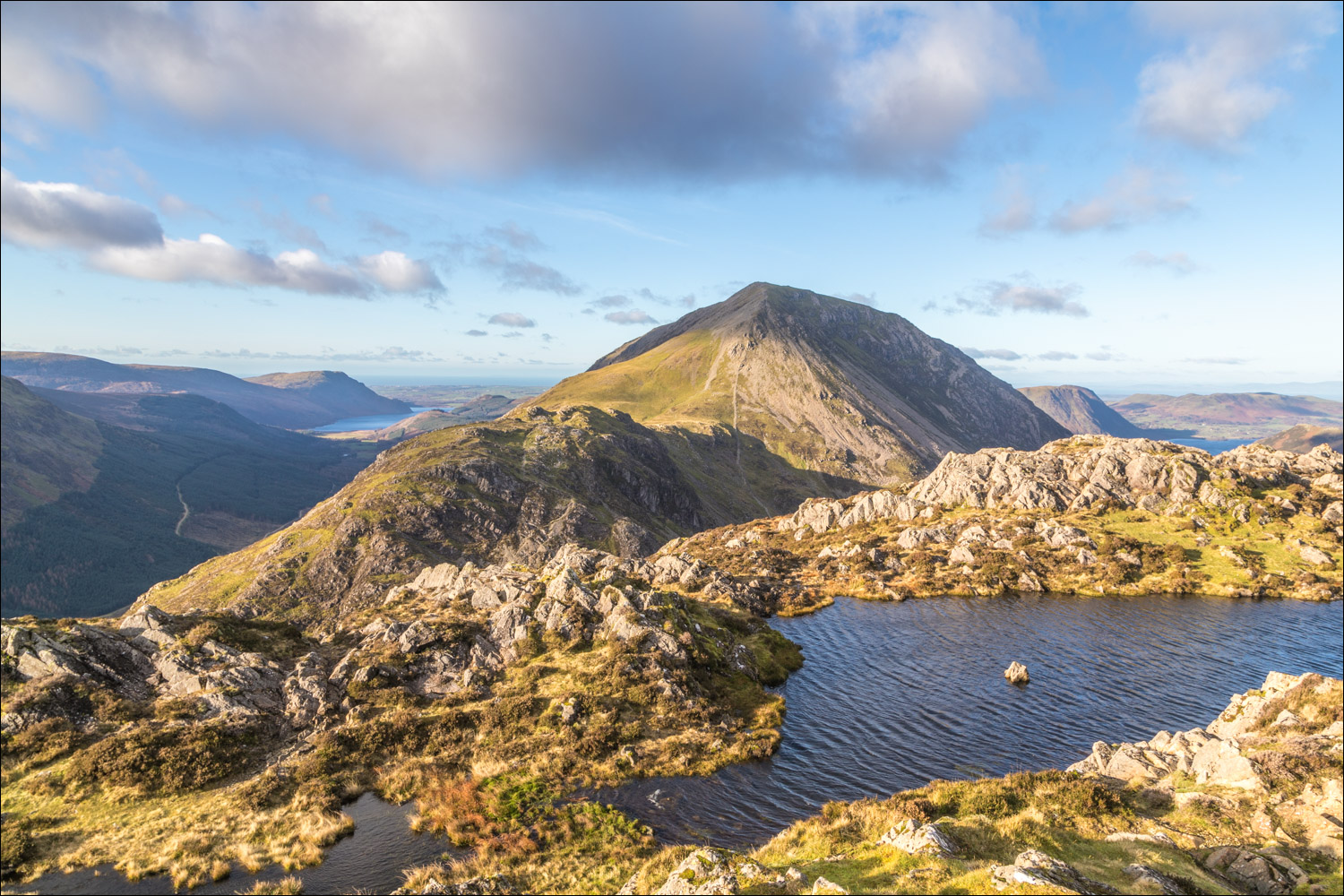
A small tarn below the summit looking towards Pillar on the far side of Ennerdale

Fleetwith Pike again as the path passes by some more crags

Another rocky ledge leads us to the summit of Haystacks

The summit of Haystacks, which consists of two small ridges separated by an unnamed tarn

Ennerdale and High Crag from Haystacks

It was bitterly cold at the top so we didn't linger, and set our sights on the descent. Innominate Tarn holds the key to this and we follow a path towards it, with Great Gable dominating the background

Innominate Tarn, a contradiction in terms, where Alfred Wainwright's ashes are scattered

We follow a path by the left hand edge of the tarn

Looking back to Pillar...


A direct descent is impossible due to the crags on the north face of Haystacks, so we have to traverse around the back of Green Crag mid picture to find a safe way down

Looking down to the two descent paths. The lower one is shorter in distance but rougher, and that's the one we'll be taking

The higher path from the lower one - thanks to a gully between the two it's not possible to get from one to the other

Looking back along Warnscale Beck to Green Crag

At last we arrive on the valley floor. After crossing the bridge over Warnscale Beck we head back to Gatesgarth to end a superb walk

Next morning, a red squirrel in the garden
