
Route: Hadrian’s Wall and Vindolanda
Area: Northumberland
Date of walk: 28th August 2021
Walkers: Andrew and James
Distance: 7.5 miles
Ascent: 1,200 feet
Weather: Sunny
Hadrian’s Wall is 73 miles long and stretches from coast to coast. It was built by the Roman Army on the orders of Emperor Hadrian following his visit to Britain in AD 122 and its purpose was to guard the north-west frontier of the Roman Empire. Today’s walk covers what is considered to be the most scenic section of the wall
We started from the car park at The Sill, a discovery centre at Once Brewed in the Northumberland National Park, where there is a shop, a café and much more besides. The walk could be started just as conveniently from the nearby Steel Rigg car park. Either way, charges apply
After crossing the road we headed north uphill, following a waymarked path towards Hadrian’s Wall. We then arrived arrived at the wall, and followed its course steeply uphill to the top of Peel Crags. The rollercoaster path continued to Milecastle 39. Milecastles were small forts (fortlets), and were placed at intervals of approximately one Roman mile along the wall. We then passed over Highshield Crags, where there are sharp drops down to a lake known as Crag Lough. We continued as far as ‘Turret 37a’ shown on the OS map and at this point we bid a reluctant farewell to Hadrian’s Wall in order to include the Roman fort of Vindolanda in our circuit
We descended south, initially beside a dry stone wall. The path was quite faint, and took us down to the B6318 which we followed for a few yards, and then crossed over to join a lane. Most of the remainder of the walk was on tarmac from this point, not a major issue as these are quiet lanes with very little traffic. Just before the limekiln at Crindledykes we were able to leave the lane briefly and take a short cut along a path through fields. We arrived at the entrance to the museum at Vindolanda, which is also the entrance to the fort. The museum is a fascinating place and is well worth a visit. It is full of artefacts uncovered during the excavations at the fort (which are still ongoing), and gives an insight into what daily life was like for the inhabitants of Vindolanda
We then wandered around the atmospheric ruins of the fort before leaving via the west exit and following lanes back to the start. It had been a wonderful walk, full of interest throughout
I should mention that about half the mileage is along tarmac. This is a price worth paying if the intention is to visit Vindolanda, but not otherwise. If the fort is not on the agenda it would be more satisfactory to plan a linear route along Hadrian’s Wall, taking advantage of the amusingly named AD122 bus service, which runs a regular shuttle between various points along the wall
Click on the icon below for the route map (subscribers to OS Maps can view detailed maps of the route, visualise it in aerial 3D, and download the GPX file. Non-subscribers will see a base map)

Scroll down – or click on any photo to enlarge it and you can then view as a slideshow

The start of the walk from The Sill Discovery Centre

Having crossed the B6318, we follow this lane uphill to join Hadrian's Wall at Turret 39A

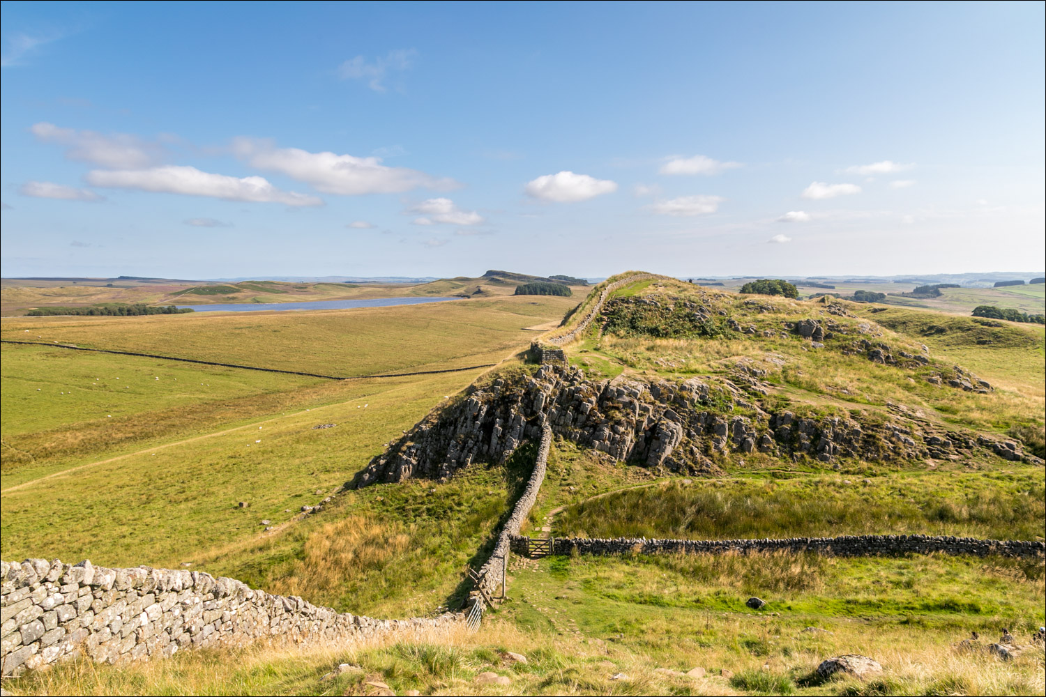
We arrive at Hadrian's Wall and climb up Peel Crags via a steep rocky staircase

Looking back

James and I set off along the undulating path

The Wall was constructed mainly from stone and in parts from turf. It was six metres high in places and up to three metres deep.

It’s thought to have taken three legions of infantrymen around six years to complete the Wall. Each legion was around 5,000 men strong

Looking back along our path

Crag Lough ahead, which was formed by glaciers in the last Ice Age and is one of the four Roman Wall Loughs

We pass by the remains of Milecastle 39. Each milecastle on Hadrian's Wall had two associated turret structures. These turrets were positioned approximately one-third and two-thirds of a Roman mile to the west of the Milecastle. The turrets associated with Milecastle 39 are known as Turret 39A and Turret 39B

Looking back down to Milecastle 39

Looking back to Sycamore Gap, which has become an iconic landmark associated with Hadrian's Wall

James surveys the scene from Highshield Crags

We follow the path above the crags, with Crag Lough below

Beyond Crag Lough we approach Hotbank and Milecastle 38

Hotbank Farm and the adjacent Milecastle 38

Beyond the farm there's another ascent - this is a route of many ups and downs

A view back along our route so far


Broomee Lough in the distance

Miles of open countryside looking south

Cuddy's Crags ahead, and at the depression we turn right and leave Hadrian's Wall

The start of the return leg as we follow a faint path beside a dry stone wall

We climb the ladder stile and aim for the main road beyond it

Having reached the road and followed it for a few yards, we turn off and join the lane to West Crindledykes

We make a short there and back diversion to Crindledykes Limekiln, a Grade II Listed Building, and one of several built in the 19C to convert limestone to quicklime for use in farming and building

We could have continued along the lane, but preferred to retrace our steps to take a shortcut across the fields

Back on the lane, Vindolanda Fort comes into view on our right...

Vindolanda Roman Fort - we follow the lane and then a signposted track leading to the entrance

The museum at Vindolanda, home to one of the greatest Roman collections, including personal items such as shoes. This place offers an insight into how the Romans conducted their daily lives

Vindolanda Fort, with the Commanding Officer's quarters in the foreground


A view across the fort as we make our way to the exit at the western end of the site

Having left the fort, we follow a lane heading west

We pass by an attractive thatched cottage known as Causeway House

The aptly named AD 122 bus passes by, a service which provides opportunties to plan a linear walk along Hadrian's Wall

We arrive back in the Northumberland National Park. The Sills, and the end of a memorable walk, is just around the corner

Dawn on the following day, and it's worth sharing some magical misty scenes from the western Lake District...

Woodhouse Islands, Crummock Water...


Herdwick sheep at the head of the lake

The White Hut bothy at the head of Buttermere
Follow the link for more walks in Northumberland (29)
