
Route: Dale Head and Robinson
Area: North Western Lake District
Date of walk: 29th August 2017
Walkers: Andrew and Gilly
Distance: 6.1 miles
Ascent: 2,200 feet
Weather: Cloudy
Dale Head commands a wonderful view of the Newlands Valley, and an easy way of enjoying that view is to park at the top of the Honister Pass – which is what we did today. After leaving the National Trust car park and crossing the road, the path leading to the summit starts immediately. The fell stands at a respectable height of 2,473 feet but by virtue of starting from Honister we only had 1,300 feet to climb. It was easy going and after about 1 hour we arrived at the shapely summit cairn and the magnificent view from it
We then walked along Hindscarth Edge, enjoying more good views along the way, before reaching the path to Hindscarth. For anyone looking to tick off Wainwrights it would be an easy 10 minute ‘there and back’ stroll to the top of Hindscarth, but we’ve been here before and the weather was indifferent so we gave it a miss today and continued along Littledale Edge
A simple ascent took us to the summit of Robinson and from here we descended across Buttermere Moss, a rather dreary and very squelchy area where wet feet are guaranteed whatever the weather. From here we descended into Buttermere village
As this was a linear walk, we’d already planned to catch the Honister Rambler bus back up to Honister. We had about an hour to wait until the next bus, and the time was gainfully employed in the excellent Bridge Hotel. The bus arrived on schedule and took us back to the start of an enjoyable walk. If anyone thinks that it’s cheating to start a fell walk from an altitude of 1,190 feet then it is of course possible to reverse the direction of travel described here
For other walks here, visit my Find Walks page and enter the name in the ‘Search site’ box
Click on the icon below for the route map (subscribers to OS Maps can view detailed maps of the route, visualise it in aerial 3D, and download the GPX file. Non-subscribers will see a base map)

Scroll down – or click on any photo to enlarge it and you can then view as a slideshow

Red squirrel this morning - they've started burying hazelnuts around the garden in readiness for winter, and I often wonder if they remember where they've cached them

Honister Hause at 1,190 feet, and we cross the road to start our climb

Looking back down to the Honister Slate Mine

Honister Crag

The fence makes a perfect guide to the top

Herdies

Looking back...


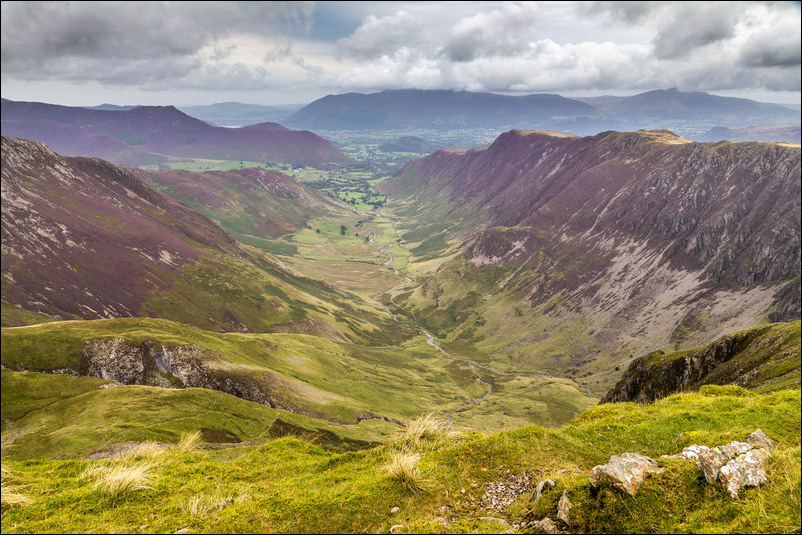
We know what's in store as we reach the summit cairn on Dale Head...

...this - the magnificent view along Newlands, with Skiddaw in the distance

Blencathra beyond High Spy

The ridge leading from Catbells

We descend from Dale Head to follow the path along Hindscarth Edge

More views along Newlands as we progress

...and on our left Buttermere comes into view

Our next objective, Robinson, in the distance

Looking back to Dale Head

Our start point at Honister Hause comes into view

Buttermere, and heather on the flanks of Robinson

Littledale Edge leading up to Robinson

Comb Beck waterfall on the far side of Buttermere

The Honister Pass

Fleetwith Edge

Honister Hause again

A view back to Dale Head

...and to Honister Hause

Crummock Water and Loweswater from the summit of Robinson

We start the descent from Robinson, with Sourmilk Gill in the background

We have to cross the soggy morass which is Buttermere Moss - not a pleasant section of the walk

Red Pike

Rannerdale Knotts on the right

Buttermere

Buttermere village below

Sail Beck

Descending from High Snockrigg

We arrive back to valley level - St James' Church Buttermere, where there is a memorial to Alfred Wainwright

The end of today's walk

The weather had been gloomy and dull for the most part, but later on there was a surprisingly good sunset in nearby Lorton Vale...

