
Route: Colle Di Tora
Area: Central Italy
Date of walk: 29th May 2023
Walkers: Andrew and Gilly
Distance: 1.4 miles
Ascent: 100 feet
Weather: Sunny and warm
After yesterday’s walk around the charming village of Posticciola we decided to visit two more nearby villages in the eastern Sabina area, both of them on the shore of Lake Turano. This is one of the most scenic places in the Lazio region, although the lake is in fact a reservoir – the dam which created it is clearly visible from Posticciola
The dam was built and put into operation in 1938 and in October that year, while the waters were already rising, the inhabitants built boats to harvest their remaining crops not yet submerged. In the winter, the valley disappeared beneath the waters and the farmland was lost forever
The reservoir was created to obtain electricity and also to regulate the flow of the River Turano so as to prevent the frequent floods that damaged the local plains, but it took with it the rich lands of the farmers, forcing them to sell their land in exchange for a few liras. For the locals, the lake only caused problems and gradually Colle di Tora and the neighbouring villages began to empty
We parked on the outskirts and walked along the main street into the old part of the village, which is is built on a narrow peninsula jutting out into Lake Turano. The waters of the lake are so close that it’s hard to believe that this was a hilltop village less than a hundred years ago. There are good views across the lake from both sides of the village, especially towards Castel di Tora which we would visit later in the day
We strolled through the narrow streets and alleys to the tip of the promontory and then joined a track which leads back along its eastern shore
During the course of our short stay in the Sabine Hills area we visited seven ancient small villages and towns – Posticciola, Colle di Tora (today’s walk), Castel di Tora, Rocca Sinibalda, Toffia, Frasso Sabino and Monteleone Sabino. These general comments apply to all of them, and no doubt to the many other old villages in the region. Anyone following our footsteps is advised to park outside the old areas for two reasons: firstly, traffic regulations are in place which restrict entry to locals and, secondly, the streets are very narrow and winding, and inevitably peter out. Once in, it would be hard to get out. These quiet communes do not cater for mass tourism and although there may be the occasional village shop, local bar or restaurant there is no guarantee that it will be open for business. I’ve provided the customary route maps of our walks, but it’s not necessary to follow a set route. There are numerous alleys, staircases and narrow passageways and it’s best to follow whichever of these looks to be the most tempting
Click on the icon below for the route map
![]()
Scroll down – or click on any photo to enlarge it and you can then view as a slideshow

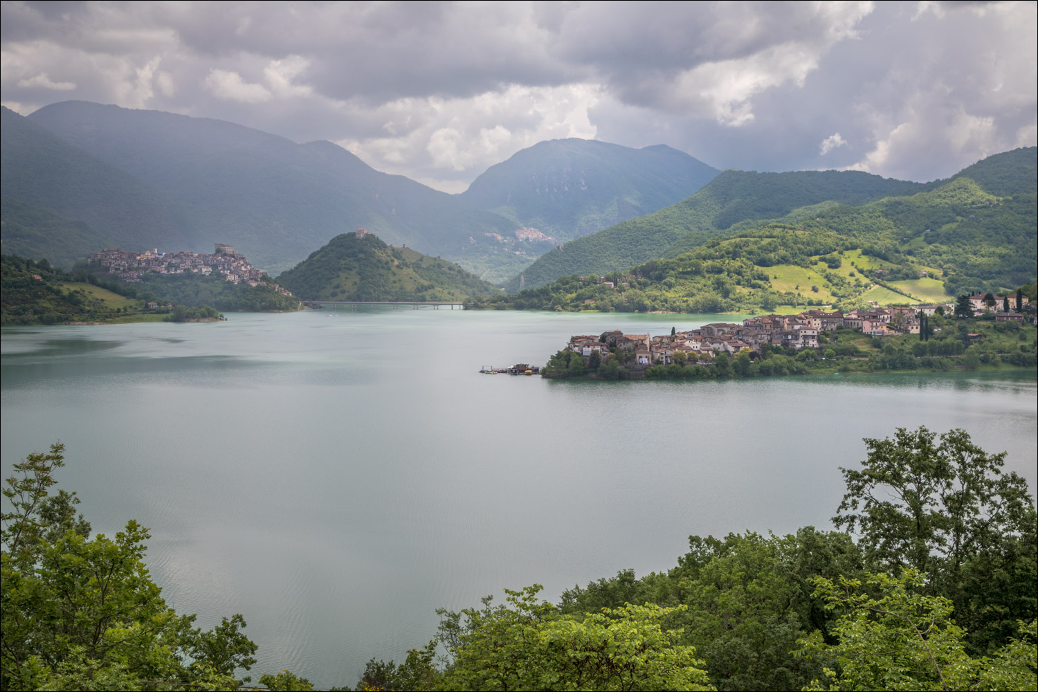
A roadside photo of Colle di Tora, illustrating its location on a peninsula jutting out into Lake Turano. The bridge to the neighbouring village of Castel di Tora can just be seen on the left

View from our parking space at the start of the walk

We follow the road into Colle di Tora

Views across Lake Turano to Castel di Tora...


We walk into the old part of the village

The village square...


Start of the lakeside return, with views across Lake Turano to Castel di Tora, where we'll be shortly...


Looking back towards the dam


Piazza Borghese


Looking back to the old part of Colle di Tora

More views across Lake Turano to our next destination, Castel di Tora…


Follow the link for more walks in Italy (23)
