
Route: Aber Falls
Area: North Wales
Date of walk: 19th September 2021
Walkers: Andrew and Gilly
Distance: 4.6 miles
Ascent: 900 feet
Weather: Cloudy with some heavy rain, gradually clearing
Today’s walk got off to a bad start. We parked at Bont Newydd, where the cash-only ticket machine prominently stated a fee of £5. After inserting the advertised sum the machine then informed us that the fee was £6. We didn’t have any more spare change, so left a note on the dashboard, with expletives deleted. Anyone following this walk is advised to bring plenty of £1 coins
We set off into the woods via a nearby gate and our mood wasn’t improved by the onset of drizzle which was replaced further on by heavy rain, causing the camera to be stowed away. We entertained doubts about continuing, but at least the rain would feed the waterfalls – the object of today’s walk
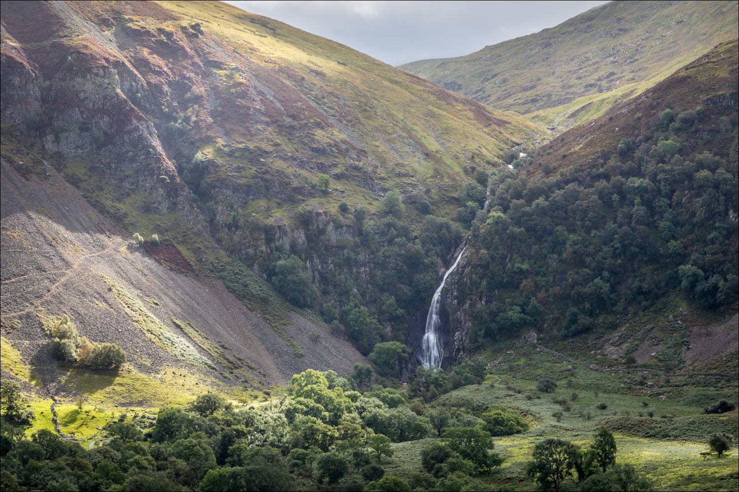
The Aber Falls (Rhaeadr-fawr) are one of the highest and most spectacular in Wales, plunging 120 feet down over cliffs at the head of the valley and are set in the Coedydd Aber National Park. The anticipation of seeing this spectacle caused us to persevere through the rain and we were glad to have done so as the weather improved as we reached the falls. It was a wonderful sight and a natural viewing area afforded close access
It’s possible to shorten the walk by retracing your steps from here, but I wouldn’t advise that as some of the best views of the falls are on the return leg. We crossed a footbridge below the falls to join a path below a dry stone wall. This took us past a smaller waterfall Rhaeadr-bach, before curving to the right and heading back down the valley
As we followed the grassy track along the west of the valley there were wonderful views back to both falls, enhanced by some pools of sunlight. After passing under some power lines, a new panorama opened up in front of us, spanning Anglesey, the Menai Strait, Puffin Island and Great Orme (which we’d visit for another walk in the afternoon)
We descended to the village of Abergwyngreyn enjoying wonderful sea views for much of the way and, on reaching the village, we turned right and returned to the start via the lane back to Bont Newydd
Click on the icon below for the route map (subscribers to OS Maps can view detailed maps of the route, visualise it in aerial 3D, and download the GPX file. Non-subscribers will see a base map)

Scroll down – or click on any photo to enlarge it and you can then view as a slideshow

The start of the walk from the lower car park at Bont Newydd. Most people walk there and back, but we'd planned a longer circular walk

We enter into the Coedydd Aber National Nature Reserve

The way ahead

Heavy rain for a while, but we were glad to have persevered as the light was superb once the clouds passed over

A glimpse of the falls through the trees

The main waterfall, Rhaeadr-fawr, comes into view...

We follow the path to the foot of the waterfall...


We cross the footbridge over the Afon Rhaeadr-fawr to admire the falls from the other side...


Anyone planning a short 'there and back' walk would return here, but we carry on across the head of the valley

A view back to Rhaeadr-fawr

We pass by the lesser known of the two falls, Rhaeadr-bach

The first of many views back to the Aber Falls, in gradually improving light

Rhaeadr-bach

The green path forks and we turn right here

Heavenly views back as the weather continued to clear...


A last lingering look back to Aber Falls, and we now turn our attention to the views ahead...

After passing under some unsightly power lines, the sea comes into view

Puffin Island

Looking along the coast towards Great Orme, above Llandudno

Anglesey in the distance as we descend

We fork off to the right here

Great Orme, which will be the venue for this afternoon's walk

Anglesey again

The tip of Anglesey and Puffin Island

We turn sharp right here in the direction of Abergwyngregyn

Great Orme again

Abergwyngregyn below. When we reach the village lane we turn right and walk along it back to the start of a wonderful walk
Follow the link for more walks in Wales (17)
