
Route: Aira Force
Area: Eastern Lake District
Date of walk: 30th January 2020
Walkers: Andrew and Gilly
Distance: 2.9 miles
Ascent: 500 feet
Weather: Low cloud and constant drizzle/light rain
The Lake District was shrouded in low cloud this morning – the bases of the fells were barely visible, let alone their tops. Even a low valley route would have offered no views, so we decided on a woodland walk instead. We drove over to the east of the district and parked in the main National Trust car park near the shore of Ullswater (where there is an information kiosk/gift shop and a tea room). In fair weather conditions this walk combines well with an ascent of Gowbarrow Fell (click here for the route). There are wonderful views of Ullswater from here, but there would have been no point in doing that today
We followed the path for a short distance up the valley, passing by some wonderful old trees as we did so. In 1846 the Howard family of Greystoke Castle created an arboretum below Aira Force, planting over 200 specimen conifers (firs, pines, spruces and cedars) from all over the world, including a Sitka Spruce now 118 feet high. Our route would take us along one side of Aira Beck and back along the other
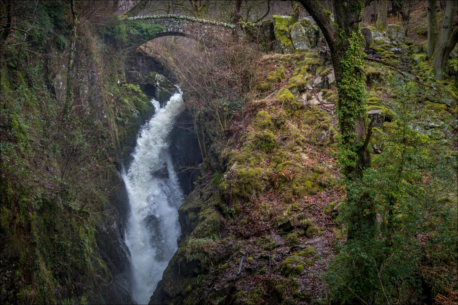
We decided to walk anti-clockwise, which would keep the beck on our left, and so crossed a bridge and continued to climb up the valley. After a few minutes a loud roar indicated that Aira Force was just around the corner, and we made a short diversion to see it. The force was on good form after much recent rain. It plummets over a precipice in a single 65 foot leap and is a wonderful sight and sound
We continued to head up the valley past a succession of smaller waterfalls, some small and some large, culminating in High Force. Just beyond this point we crossed a wooden footbridge over Aira Beck to start the return journey along its opposite bank. We made another short diversion to revisit Aira Force, which is better seen from here, and we then made our way back to the start of a short but sweet walk which had been an excellent choice in today’s miserable weather
For other walks here, visit my Find Walks page and enter the name in the ‘Search site’ box
Click on the icon below for the route map (subscribers to OS Maps can view detailed maps of the route, visualise it in aerial 3D, and download the GPX file. Non-subscribers will see a base map)

Scroll down – or click on any photo to enlarge it and you can then view as a slideshow

The start of the walk, and one of the attractive signs installed by the National Trust in the area

We cross the footbridge over Aira Beck and ascend the stone steps on the far bank

Aira Beck from the bridge

We pass around this giant sitka spruce which is flexing its muscles

The path rises up the valley, with Aira Beck on our left

We can hear the roar of Aira Force, which is just around the corner

We detour to visit (but don't cross) the footbridge built in memory of Cecil Rice, poet, privy councillor and HM Ambassador to the USA during WW1

Aira Force from the bridge - the fall is 65 feet

At the top of Aira Force is another bridge, built by friends of Stephen Rice who lived 1856-1902

Looking down on Aira Force as it crashes onto the rocks below

We continue up the valley, with Aira Beck still on our left


The far point of the walk, where we cross a wooden footbridge and head back down the valley

We pass by the upper cascades in Aira Beck...


Further along the path

More cascades as we continue down the valley...


We pass by the bridge at the top of Aira Force

Aira Force again...


We re-enter the arboretum near the end of the walk...

Some of these trees are over 150 years old


The trunk of a monkey puzzle tree at the end of a very enjoyable walk, despite the weather
