
Route: Latrigg
Area: Northern Lake District
Date of walk: 19th November 2025
Walkers: Andrew and Gilly
Distance: 5.3 miles
Ascent: 1,000 feet
Weather: Sunny, snow on the tops, very cold
We awoke to fresh snow on the fells and our thoughts soon turned to Latrigg, which is a good choice when the higher fells would be bitterly cold – the wind chill factor from Skiddaw, its taller neighbour, was -16c today. Latrigg stands at a modest 1,203 feet, but it punches well above its height in terms of the views from the summit. These are just as good as those from Skiddaw, which towers up behind it and is nearly 2,000 feet higher. The only drawback of Latrigg is that its proximity to Keswick, the ease of the ascent, and the superlative view make it a little too popular at times. This isn’t a walk we’d follow at peak times
We parked as usual on the roadside at Briar Rigg and walked up Spooney Green Lane, crossing the bridge over the busy A66 along the way. After a while we joined the path leading to the top of Latrigg. The climbing was easy throughout and, as Wainwright puts it in his Guide to the Lakeland Fells, ‘anybody who cannot manage this short and simple climb is advised to give up the idea of becoming a fellwalker’
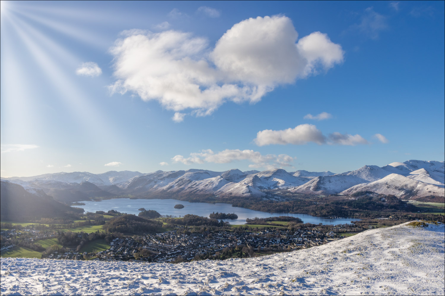
Before long we arrived at the wonderfully situated bench near the summit. We’d been keenly anticipating this moment and weren’t disappointed. The view was as glorious as ever – the rooftops of Keswick below, the full length of Derwent Water beyond, and an array of lakeland peaks, all displayed in early morning sunshine
Having savoured the views we started the descent along a grassy path which leads east along the Latrigg ridge. The angle is very gentle and it’s easy going all the way. On arriving at the end of the ridge we decided to take a route back which we’d followed two years ago – a quiet lane which leads through Brundholme Wood. The lane contours around the lower slopes of Latrigg, descending gently all the way down, and is a very easy way back
For an alternative slightly longer return via the Keswick to Threlkeld Railway Track, click here and for a shorter 4 mile there and back version of the walk click here
Click on the icon below for the route map (subscribers to OS Maps can view detailed maps of the route, visualise it in aerial 3D, and download the GPX file. Non-subscribers will see a base map)

Scroll down – or click on any photo to enlarge it and you can then view as a slideshow

The start of the walk as we follow Spooney Green Lane, with Skiddaw left and our target, Latrigg, right

We enter Latrigg Woods, where red squirrels may be seen


An early view across to the foot of Derwent Water, Grisedale Pike and the north western fells

Skiddaw Little Man

The path zig zags up the fellside at a gentle gradient...


Derwent Water and Keswick

Looking back to Bassenthwaite Lake

The Skiddaw fells

Last of the zig zags

We arrive on the summit ridge, where a bench is well positioned to enjoy the fabulous view over Derwent Water

We follow the easy path up to the nearby summit. There is no cairn or other distinguishing feature

Derwent Water and Keswick from Latrigg

Looking back to Grisedale Pike and the north western fells

We continue to enjoy the view as we carry on along the ridge

Blease Fell, part of the Blencathra range, and the Pennines in the distance

Looking back along the ridge

A closer view of Keswick and Derwent Water, with Catbells on the far side of the lake

We head towards Blease Fell

Low Rigg and High Rigg, with Clough Head and the long spine of the eastern fells beyond

Looking back

We continue towards Blease Fell...


Great Mell Fell ahead as we continue the descent

Blease Fell on our left

We approach the far point of the walk, looking towards Clough Head and High Rigg

We turn right beyond this gate to join a quiet track which will take us back to the start...


The views become restricted as we walk through Brundholme Wood

We arrive back on the outskirts of Keswick and from here it's a short stroll back to Briar Rigg and the end of a wonderful walk
