
Route: Seathwaite Fell
Area: Southern Lake District
Date of walk: 26th September 2025
Walkers: Andrew and Gilly
Distance: 6.5 miles
Ascent: 1,800 feet
Weather: Mixed sun and clouds, cold wind where exposed
The village of Seathwaite and its fell, which towers over it, are reputed to have the heaviest rainfall in the country. Today thankfully proved to be an exception to the rule. There is ample roadside parking before the village, though it’s best to arrive early as Seathwaite is a springboard to Scafell Pike and the place can be busy at peak times
Having walked through Seathwaite Farm, located in the very centre of the Lake District, we followed the path beside Grains Gill and then crossed over Stockley Bridge, a beautiful old packhorse bridge which is Grade II listed. We left the Grains Gill path to climb above Taylorgill Force waterfall, and then turned off left to join a faint path by an unnamed stream. This is easily missed, and the only sign of it is a pile of stones, too small to be digified as a cairn. The path is quite faint and grassy at first, but becomes much steeper and rougher nearer the top. We followed the path to the summit cairn (which isn’t at the highest point of the fell) and savoured the wonderful views all around, especially those looking back into Borrowdale. This is a good place to admire some of the highest peaks in the district, including Great Gable, Great End and the Scafells
We then set off along the lumpy summit ridge in the direction of Great End, which is the key to navigating this complicated area, where the paths are very faint. We passed by several attractive unnamed tarns before arriving at Sprinkling Tarn, set in an amphitheatre of some of lakeland’s finest fells. The tarn is accredited as the source of the River Derwent. We walked around the right of the tarn and then joined the Sty Head path which we followed to Ruddy Gill, turning left here to head back down into Borrowdale via the Grains Gill path. On reaching Stockley Bridge we retraced our steps back into Seathwaite to end a wonderful walk
For other walks here, visit my Find Walks page and enter the name in the ‘Search site’ box
Click on the icon below for the route map (subscribers to OS Maps can view detailed maps of the route, visualise it in aerial 3D, and download the GPX file. Non-subscribers will see a base map)

Scroll down – or click on any photo to enlarge it and you can then view as a slideshow

At the start of the walk we pass through Seathwaite Farm. Our objective, Seathwaite Fell, lies ahead

We follow the Grains Gill path, a popular way to access Scafell Pike

Seathwaite Fell looms ahead

Taylorgill Force on our right - our route will take us above the falls

We'll turn off to the right shortly

Stockley Bridge, which is Grade II Listed and dates back to the early 18th century

We look up to Seathwaite Fell before crossing over the bridge

We head towards Base Brown as we cross Stockley Bridge

Looking back along Grains Gill

Seathwaite Fell to the left

Base Brown ahead

Looking back to Seathwaite

We follow a line of trees above Taylorgill Force

Looking back along the path

Styhead Gill on our right as we continue uphill

Another view back to Borrowdale

A photo with no merit, save to point out an easily missed junction just beyond an unnamed stream. We leave the main path here and follow a faint grassy path to the left, the key to the ascent of Seathwaite Fell

Looking back to Seathwaite

Borrowdale, and a glimpse of Derwent Water

A herdwick surveying his domain

After a steep climb the gradient eases as we look up to Seathwaite Fell

Skiddaw, Derwent Water and Blencathra beyond an unnamed tarn

Great Gable, a majestic sight

We arrive at the summit area of Seathwaite Fell, here looking towards Glaramara

Great Gable again

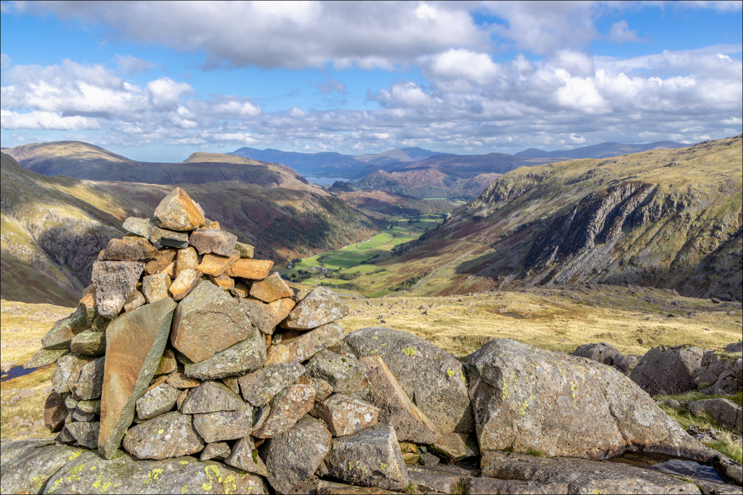
Summit cairn on Seathwaite Fell, 1,970 feet above sea level

Great Gable and Green Gable

The view of Borrowdale and Derwent Water from Seathwaite Fell, which we enjoyed in perfect solitude

We descend from the summit and head towards Great End through some undulating and often pathless terrain

Looking back to Seathwaite Fell

The Irish Sea on our right

We pass by another unnamed tarn

Scafell, and the chasm of Piers Gill, with Wasdale on the right

We pass to the right of a tarn below Great End

Sprinklng Tarn comes into view and beyond it lies the far point of the walk

We cross the stepping stones and walk around the head of Sprinkling Tarn

We walk above Sprinklng Tarn before turning left to head back towards Borrowdale

Skiddaw and Derwent Water in the distance as we follow the path above Ruddy Gill on our left

The map can be stowed away at this point, the obvious path ahead leads straight back to the start

Castle Crag centre of picture

We arrive back at Stockley Bridge and from here we retrace our steps back to the start

Two days later, and it's worth sharing a few photos of the Buttermere Valley on a misty morning

Great Gable in the distance overlooking the valley


