
Route: Around Hackness
Area: North Yorkshire
Date of walk: 13th July 2022
Walkers: Andrew and Gilly
Distance: 2.7 miles
Ascent: 300 feet
Weather: Sunny and very warm
Hackness is a small and unspoilt village near Scarborough and is located in the North York Moors National Park. Numerous walking routes radiate out of the village in all directions. This is a short walk, and a good introduction to the village and its surrounding area
We were staying at Derwent View holiday cottage, so we started from there. Anyone not staying at the cottage could start just as easily from the nearby village hall. After walking along the village street we turned right at the war memorial by the village hall, and just beyond Mill Farm we left the road to climb steeply up a bank to join a path which hugs the edge of Walker Flat Wood. There are lovely views back over the valley from here
The path leads into the woodland briefly before emerging above St Peter’s Church and Hackness Hall. The hall and its landscape gardens were created in the 1790s, and the house is a Grade I listed building. Neither is open to the public. The Hackness Shame is an entertaining story about an event which occurred here in 1600
Although it’s possible to leave the woodland path via a rickety old stile, a fence has recently been erected in the field (crossing the line of a public footpath as shown on the OS map), making it easier to stay in the woodland until a second stile is reached. This emerges into the field above Hackness Hall. The view over the Hall and St Peter’s Church, looking into Whisperdales, is superb – one of the best in the area
After passing above the hall we descended to the road and turned left, passing by the entrance to the hall. We made a short detour to St Peter’s Church and then continued along the village road. We turned off to follow a track which branches off the road and offers good views along the valley. The up and down track brought us back to the valley road, and we turned left here to return to the start of the walk
For other walks here, visit my Find Walks page and enter the name in the ‘Search site’ box
Click on the icon below for the route map (subscribers to OS Maps can view detailed maps of the route, visualise it in aerial 3D, and download the GPX file. Non-subscribers will see a base map)

Scroll down – or click on any photo to enlarge it and you can then view as a slideshow

Derwent View, Hackness. As mentioned in the introduction, anyone not staying at the cottage could start the walk from the village hall, a little further down the road


We walk through the viillage and turn right at the village hall

Looking back as we leave Hackness

We pass by Mill Farm on our left

Just beyond the farm we pass through this gatge and climb up a steep bank

Looking back across the road towards Coomb Hill and Mount Misery

We climb to the lower edge of Walker Flat Wood and then traverse around the hillside

A view over Mill Farm towards the start of the walk

Looking back along our path

We cross this stile to follow a path at the edge of the wood

The village of Hackness is divided into two parts, and we are treated to views of the eastern half of the village which contains St Peter's Church and Hackness Hall

Hackness Hall and Low Dales beyond

We emerge from the wood and follow a path across the hillside

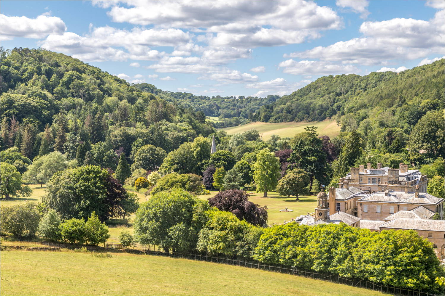
The highlight of the walk - wonderful views over Hackness Hall into Low Dales

St Peter's Church, which we'll visit later in the walk

A bucolic scene

We cross this stile and descend to the road

On arriving at the road we turn left to head back into Hackness....


We pass by the entrance to Hackness Hall

We continue beyond a bridge which enables the owners of the Hall to access gardens on the other side of the road

We visit St Peter's Church Hackness to pay our respects to Auntie Marjorie, who lived in and loved Hackness

It's possible to continue along the road back to the start, but we preferred to follow this track below Hackness Head...


A view across the valley

We descend to the road and turn sharp left. The cottage is just around the corner....

Back to the start of a lovely short walk
Follow the link for more walks in North Yorkshire (151)
