
Route: Whiteside and Hopegill Head
Area: Western Lake District
Date of walk: 6th April 2015
Walkers: Andrew and Gilly
Distance: 8.3 miles
Weather: Sun, blue skies – and a cloud inversion
There were patches of low mist in Lorton Vale, but the cloud base was low and thin and the conditions looked just right for a cloud inversion. We started the walk from home and walked along the lane to Miller Place (anyone else following this highly recommended route could start from Lanthwaite Green or Swinside)
We climbed up Whiteside via Dodd and its ridge, very easy though the huff and puff factor is quite high. When we emerged onto the summit ridge we made a short detour to the western top of the fell. As we’d hoped, there was a cloud inversion and the conditions were fantastic. We could see as far as Criffel in Scotland across a sea of cloud
We left the west top of Whiteside to walk along the wonderful ridge to Hopegill Head, one of my favourite miles in lakeland. The views from the airy top of Hopegill Head were wonderful and having savoured them for a while we descended down Sand Hill to Coledale Hause
Our descent route to valley level took us along Gasgale Gill, following Liza Beck and a series of cascades all the way down. The path is eroded in parts and there was a risk (to dignity rather than life) of slipping down into the beck at times. Having reached Lanthwaite Green we followed the path along Lorton Vale back to the start
It had been a red letter day
For other walks here, visit my Find Walks page and enter the name in the ‘Search site’ box
Click on the icon below for the route map (subscribers to OS Maps can view detailed maps of the route, visualise it in aerial 3D, and download the GPX file. Non-subscribers will see a base map)

Scroll down – or click on any photo to enlarge it and you can then view as a slideshow

As we leave the house the blue sky just visible through the mist indicates a possible a cloud inversion higher up

We will turn left uphill just before Miller Place ahead

The outgang up the lower slopes of Lorton Dodd

Lorton Vale

The path snakes round the side of Dodd

Looking across the valley again

Thackthwaite nestling between Low Fell and Fellbarrow

Looking up Hope Gill to Hopegill Head

A sea of cloud approaching from Scotland and about to cover Lorton

Not a good photo, but interesting that the hill in the far distance is Criffel - in Scotland

Looking back to Dodd as we start up the ridge to Whiteside

Thackthwaite again as the clouds make their way along the valley

We finally emerge onto the summit ridge of Whiteside

We make a short detour to our right in order to visit the west top of the fell

A spectacular view of Dove Crags on Grasmoor. Below is Gasgale Gill, which will be our descent route

Crummock Water is down there

Another view of our return route along Gasgale Gill

The ridge leading to Ladyside Pike

Crummock Water from Whiteside

and again

The small settlement of Loweswater


Looking back down on our ascent route up the ridge from Dodd

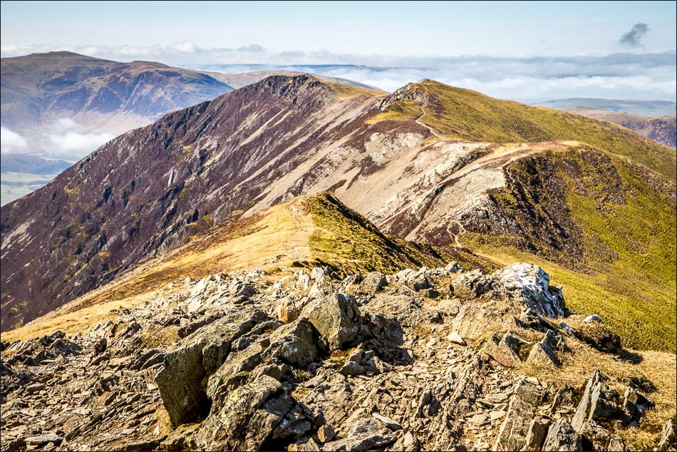
Eventually we tear ourselves away from Whiteside to start out along the wonderful ridge to Hopegill Head

Looking back along the ridge to Whiteside

Ladyside Pike

Summit of Hopegill Head, looking back along our route

Grisedale Pike

Sand Hill

We descend the rather loose slopes of Sand Hill towards Coledale Hause, then turn right down the gully below

Keswick from Coledale Hause

There followed a lenghty descent along Gasgale Gill, with a series of lovely waterfalls along the way……


Lanthwaite Green - we don’t cross the bridge over the beck, and turn right just beyond it

Low Fell across Lorton Vale - we follow the lovely path along the valley

A couple of herdies

A welcome sign of spring - a Peacock butterfly

The end is in sight

The circuit is complete as we join the outgang again

The home straight
