
Route: Shap Abbey
Area: Eden Valley
Date of walk: 1st March 2017
Walkers: Andrew and Gilly
Distance: 6.6 miles
Weather: sunshine and showers
We parked in the village of Shap in the Eden Valley district of Cumbria, on the fringe of the Lake District. It was raining as we set off and the skies looked unpromising, but as we followed Keld Lane to the attractive village of Keld the sun broke through, showing the lovely rolling countryside in a much better light
The path from the pretty village of Keld towards Shap Abbey passed through a field which had been turned into a quagmire by a herd of horses – we pitied them as there was hardly any grazing left in the sea of mud. It was an unpleasant section of the walk, but at least we were able to make our way to drier land, unlike the horses
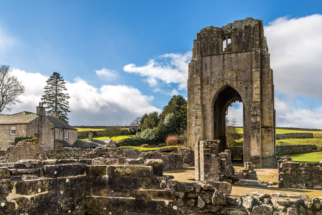
As we walked along the top of Abbey Wood views of Shap Abbey appeared and we descended to explore the ruins of this atmospheric place, founded in the 12th century and once occupied by the Premonstratensian order of canons
We climbed away from the abbey following paths above the River Lowther, which we crossed near Rosgill, and from there we walked above the other bank of the river, turning away from it near Shap Abbey to return to Shap
It had been a delightful walk in an area which is unfairly overlooked thanks to its proximity to lakeland. In any other part of the country tourists would be here in their droves – a major part of its appeal to me
Click on the icon below for the route map (subscribers to OS Maps can view detailed maps of the route, visualise it in aerial 3D, and download the GPX file. Non-subscribers will see a base map)

Scroll down – or click on any photo to enlarge it and you can then view as a slideshow

Looking back to Shap at the start of today’s walk

A network of dry stone walls

One of the many squeeze stiles along the way - and Bonnie

The Goggleby Stone

Keld Lane


Approaching Keld…


We detour briefly to the end of the little village, beyond which is a vast area of lonely and unfrequented fells

I’ll draw a veil over the mudbath of the fields beyond Keld, and skip forward to Abbey Wood on the approach to Shap Abbey


A glimpse of the abbey below Abbey Wood


We cross Abbey Bridge

Some photos of Shap Abbey…


We turn away from the abbey to head towards Rosgill

A last look back to Shap Abbey

We follow an undulating path beside a dry stone wall

Rainbow over Knipe Moor

Ruins of an old barn

We cross Swindale Beck over Parish Crag Bridge, a listed monument

Path to Rosgill, with Knipe Scar beyond

We cross the bridge over the River Lowther

The view looking north from the bridge

We walk along the road through Rosgill

Looking back to Rosgill as we start the return journey to Shap

There are good views towards the far eastern lakeland fells on our right…


Shap Abbey comes into view again

We follow a quiet lane and path back to Shap…


We arrive back in Shap to end a very enjoyable walk

As we were in the area, we decided to drive along the shore of Haweswater - here are a few photos…


Wood Howe and The Rigg

The Rigg and Rough Crag, leading up to High Street

Kidsty Pike
