
Route: Scafell and Slight Side
Area: Southern Lake District
Date of walk: 29th October 2014
Walkers: Andrew and Gilly
Distance: 7.5 miles
Ascent: 3,200 feet
Weather: Sun and blue skies, very cold on tops
In May 2004, 10 years ago, my local football team Hull City beat Yeovil Town to gain promotion from Divison Three. I heard this joyful news as I descended Scafell having completed my first round of the Wainwrights – all 214 Lakeland Fells
10 years later Hull City are in the Premiership and Gilly and I are setting off to climb Scafell again in order to complete my second round
The signs were good as we arrived in Wasdale – sun and blue skies and hardly a breath of wind. We parked in the National Trust car park at Brackenclose and after a short distance (and some dithering, as the path shown on the OS map was inaccessible) we headed up the slopes of Green How towards Scafell. The ascent was pathless at times and quite steep but nowhere difficult. As we approached Scafell the going became rockier as befits such a mountain but before long we were at the top. It was too cold up there to celebrate and, after taking a few photos, we left the summit and descended to Slight Side via Long Green
The descent from Slight Side via Broad Tongue was pathless for the most part and very juicy as we approached Burnmoor Tarn. From the tarn we made our way back to the start and as we did so the setting sun cast a glorious light over Wasdale, making this last part of the walk absolutely magical
It was a golden end to a golden day
Click on the icon below for the route map (subscribers to OS Maps can view detailed maps of the route, visualise it in aerial 3D, and download the GPX file. Non-subscribers will see a base map)

Scroll down – or click on any photo to enlarge it and you can then view as a slideshow

A promising start to the day - dawn in Lorton Vale before we set off

On the way to the start of the walk, the wonderful view along Wast Water to Wasdale Head

Looking up to Scafell Pike and Scafell as we cross Lingmell Gill at the start of the walk


Looking west along Wast Water

Scafell Pike

Wasdale Head

Wast Water, flanked by Middle Fell and Yewbarrow

Looking across to Burnmoor Tarn as we climb the steep grassy slopes of Green How

Onward and upward

Burnmoor Tarn, Illgill Head and Wast Water, with the Irish Sea beyond

An array of peaks as we get higher and the terrain becomes rockier

Summit of Scafell with Scafell Pike behind, to the left of the cairn

Mosedale

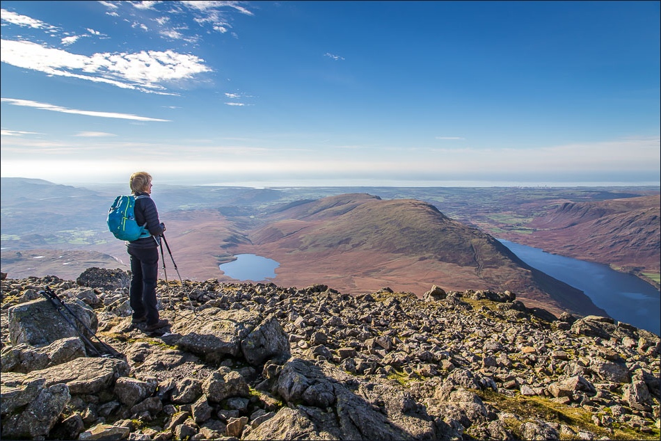
Gilly looks out to sea

We didn’t stay to celebrate as there was a bitterly cold wind

Lots of people on Scafell Pike - there was a Three Peaks Challenge event taking place

This paraglider asked us to point which way the wind was blowing as he flew by!

Descending from Scafell to the next fell, Slight Side, at the far end of the ridge ahead

Upper Eskdale


Summit of Slight Side, with Burnmoor Tarn below

Memorial on the way down


Descending the grassy and mostly pathless slopes of Broad Tongue

Burnmoor Tarn below - and some squelchy terrain to cross


Walking towards Wasdale, with Yewbarrow and Kirk Fell ahead

Lovely late afternoon sunshine on the flanks of Yewbarrow


Wasdale


Yewbarrow again

Kirk Fell and Great Gable

Yewbarrow again

The head of Wast Water

A last look back up to Scafell Pike bathing in the late afternoon sun

On the way home I stopped the car to take this photo of the Wasdale Screes plunging into Wast Water

Back home - it had been a golden day from dawn to dusk
