
Route: Rambla de Castro
Area: North West Tenerife
Date of walk: 10th February 2018
Walkers: Andrew and Gilly
Distance: 6.7 miles
Ascent: 1,400 feet
Weather: Mostly sunny
IMPORTANT NOTE: since adding this post, the route has changed due to landslides. The section between Mirador Roque Grande and Mirador Playa Los Roques is now closed. Follow this link for more information
On our last day of our walking holiday in Tenerife we decided to stay close to the coast as once again the surrounding mountains were hidden under a cloak of ‘bruma’ (low cloud)
From our base in Puerto de la Cruz we drove to the start of the walk from a free car park near the Hotel Maritimo – a building which has nothing to recommend it from an aesthetic point of view, but on the positive side its height makes it a landmark, so finding the start of the walk is not an issue
After walking past the front of the hotel we joined the attractive and well waymarked coastal path to the journey’s end at the San Pedro Mirador. There were some lovely views along the coast, interrupted briefly when we had to head uphill and walk through a residential area named (inaccurately) ‘Romantica’
Beyond this point the walk gradually increased in beauty, taking us safely across the cliffs to our destination – the mirador, from where there are superb views along the coast
At this point we had two options – a taxi or bus back to the start, or reversing our steps. The weather was good, we felt fit and the scenery was first class and so we opted for the latter, varying the return leg by a delightful initial detour through the banana plantations before regaining our original path. It was a wonderful walk and a fitting end to our short break on this beautiful island
Click on the icon below for the route map (this is now out of date as mentioned above)
![]()
SOME NOTES IN CONCLUSION
Our base for this walking holiday was the excellent and highly recommended Hotel Tigaiga in Puerto de la Cruz on the north of the island. We’d chosen the town as our base as it’s possible to access most of the best walking areas from here. As it happened, the weather prevented us from walking in the Orotava Valley behind the town – the hills were covered in thick cloud most of the time, although we did enjoy one magical misty walk in the pine forest on day 2
We used two guidebooks to plan our routes and navigate us safely along the way:
- Walk This Way Tenerife by Andrea and Jack Montgomery, who live on the island and know its paths intimately
- Walk! Tenerife by Discovery Walking Guides
There’s no point choosing between them, both are superb in different ways, and I recommend that anyone walking on Tenerife takes both
Discovery Walking Guides also publish the best walking map, though it only shows the walking areas and not the whole island, so we also purchased the 1:50,000 map by Freytag and Berndt. A good map but printed on totally inadequate paper and almost on first use tears appear and by the end of the holiday our copy was in tatters (unlike the DWG map which will last a lifetime)
The weather was particularly poor during our stay (by the normal standards of the Canary Islands) but we still managed a walk on every day bar one. We soon realised that the inland mountains were habitually covered in ‘bruma’ (thick cloud) but that the coastal areas were usually clearer. In consequence most of our walks were near the coast. We found the Anaga peninsular to be the most spectacular although there is a price to pay in the form of a tortuous car journey to get to this remote area
Anyone who hasn’t visited Tenerife may dismiss it as a hiking area, as images of sunbathing and sangria come to mind, but I hope that the photos of the past few days will persuade you otherwise – it’s a wonderful place, packed full of possible walking adventures
Scroll down – or click on any photo to enlarge it and you can then view as a slideshow

The start of our last walk this week in Tenerife. We pass by the Hotel Maritim (wondering how and why planning permission was granted)

Beyond the hotel Los Roques come into view in the bay below

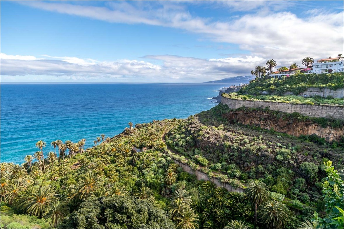
We follow the terraced path which runs across the cliff face (middle of picture)

Our route to the Mirador San Pedro is well waymarked


Los Roques again, bearing a resemblance to Durdle Door in Dorset

Looking back to the Hotel Maritim and its two oversized neighbours

We walk through a rather bland development known as Romantica, the only other blot on an otherwise perfect route

That's more like it - the first promontory is our destination...


The path is perfectly safe and there are no vertiginous moments on the whole route

We follow the path around the corner to a wooden bridge across the gorge


From the bridge we look down on the atmospheric ruin of the building which housed a water elevator, used to provide water to the banana plantations

Our path will take us through the palm grove below

The path heads inland and then back out to sea in order to cross a barranco...


Lush tropical vegetation on this section of the walk


We reach the Mirador San Pedro - this is the view looking back along our route

...and now looking the other way over the banana plantations. It was here that we decided to walk back rather than taking a bus or taxi

Looking up to the hills of the Orotava Valley, which had been completely out of sight all week

Another view along the coast and we can just make out the ruined building and the Hotel Maritim beyond it

The initial part of the return leg was via a different route, as we pass by this small chapel...


We descend to the banana plantations below...


We follow the lane between these old buildings

Bananas - thousands of them

Having reached the coastline and passed under a small tunnel we head back towards the start

An attractive cove below the mirador. Shortly after this point we rejoined our original route and retraced our steps back to the start

The three ugly sisters, the one on the left being journey's end - and yet another superb walk on the island

After finishing the walk we drove up to the hills of the Orotava Valley - we'd planned to walk here more often, but the hills had been covered in thick cloud all week

A short stroll through the ancient pine forest...


Back at the hotel, a well earned beer and the end of a wonderful walking holiday - salud!
