
Route: Mellbreak
Area: Western Lake District
Date of walk: 15th March 2016
Walkers: Andrew
Distance: 6.3 miles
Ascent: 1,800 feet
Weather: sun and blue skies
I parked in the small parking space by Church Bridge, just beyond the Kirkstile Inn, and walked towards Mellbreak along the lane. Seen from this approach, the fell looks like a pyramid and its north face appears quite formidable.
After leaving the lane and climbing up the initial grassy slopes, I came to the steep scree section which is at times is a case of two steps up, one step down. The retrospective views over Loweswater and Lorton Vale were wonderful.
I eventually emerged, panting, at the north top and then made the easy but ever juicy walk across the saddle to the south top ¾ mile away. The views from there even more wondrous than those from the north top.
I descended in the direction of Scale Force and then followed Scale Beck to the shore of Crummock Water. After walking along the shore of the lake, with Mellbreak towering above to my left, I climbed up towards Flass Wood and made my way back to the start via High Park and Low Park. It was a wonderful walk, all the better for some sun and blue sky, and although today was not the official start of spring it certainly felt like it
For other walks here, visit my Find Walks page and enter the name in the ‘Search site’ box
Click on the icon below for the route map (subscribers to OS Maps can view detailed maps of the route, visualise it in aerial 3D, and download the GPX file. Non-subscribers will see a base map)

Scroll down – or click on any photo to enlarge it and you can then view as a slideshow

Red squirrel in the garden before I set off this morning

Mellbreak from the roadside - my route will take me up the steep right hand side, along the top, down to the left and back along the shore of Crummock Water

Looking back to Church Bridge and the Kirkstile Inn from the start of the walk

I pass by Kirkgate Farm

The lane turns into a rough cobbled track

Approaching Flass Wood

Looking across the valley to Whiteside and Hopegill Head beyond

The start of the climb as I leave the track to walk up the firebreak in Flass Wood

Hopegill Head again

Looking back towards Loweswater, and the Kirkstile Inn right of picture

Sweet Lorton Vale

Whiteside, Grasmoor and the foot of Crummock Water

Loweswater

Grasmoor from the north top of Mellbreak

...and Loweswater again

A splendid array of fells ahead as I make my way across the saddle of Mellbreak

Whiteside and Grasmoor

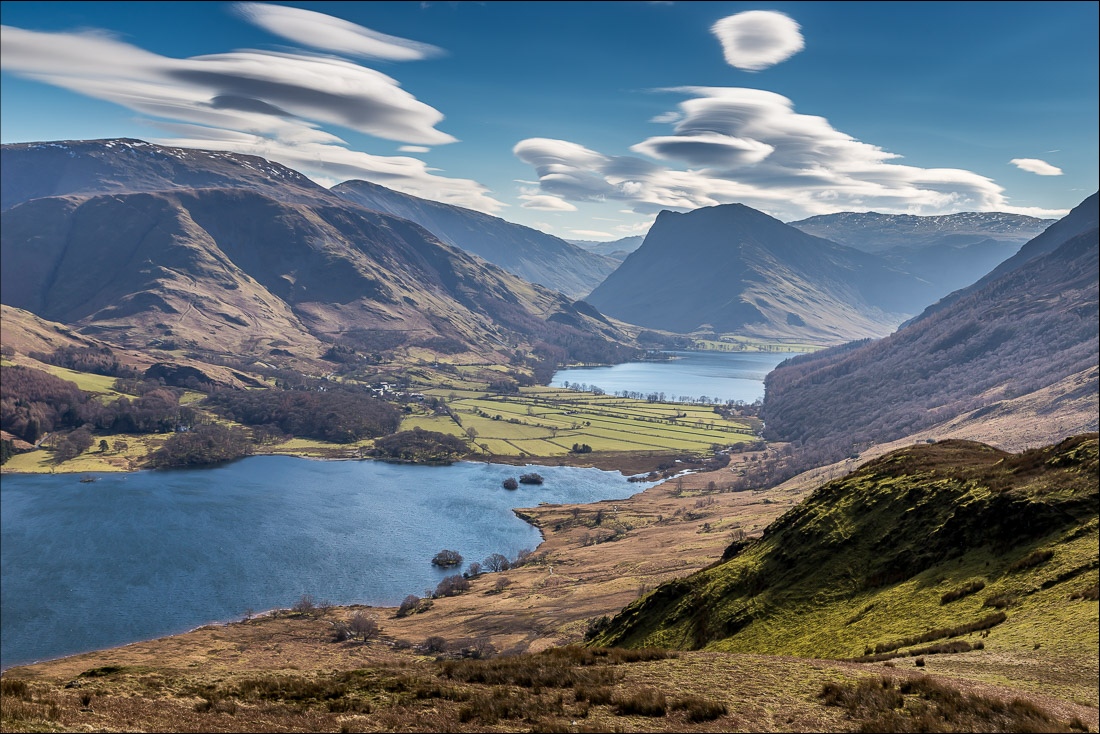
A special moment as I arrive at the south top of Mellbreak, looking towards Buttermere and Fleetwith Pike

Rannerdale Knotts

Crummock Water comes into view as I start to descend, admiring the wonderful cloud formations as I do so

Lonely Mosedale

Descending to the shore of Crummock Water

Grasmoor

High Snockrigg and Robinson

Signs of spring


Low Ling Crag, jutting out into Crummock Water

Looking back to Low Ling Crag, with Fleetwith Pike beyond


A last look back to Crummock Water as I leave the shore to walk round the flanks of Mellbreak

Flass Wood

Grasmoor

I cross over Park Bridge…

…and follow the quiet lane back to Loweswater

Looking back along the lane

The famous Kirkstile Inn - I’m looking forward to our visit here tomorrow evening

Park Beck from Church Bridge at the end of a wonderful walk
