
Route: Mellbreak
Area: Western Lake District
Date of walk: 30th March 2018
Walkers: Andrew and James
Distance: 4.9 miles
Ascent: 1,700 feet
Weather: Cloudy, improving at the end
We parked at Church Bridge near the Kirkstile Inn and walked along the lane past Kirkgate Farm. At a small wood we left the lane to walk up a firebreak in the trees, and this brought us onto the nursery slopes of Mellbreak. The initial grassy climb flatters to deceive and before long the path turns into loose stone and the gradient becomes very steep. At times it’s a case of two steps forward, one step back. It’s a thrilling climb though with no real dangers
We emerged at the north top of Mellbreak, which is marked by two small cairns. There are tremendous views back over Loweswater and Lorton Vale from here. We then followed the path across squelchy terrain to the south top, which is an easy tramp. We walked a few yards beyond the summit cairn in order to enjoy an improved view to the head of Buttermere
It was then time to consider the rest of the route. The usual way would be to descend to Scale Beck and return along the shore of Crummock Water. I’ve done that numerous times and by way of a change we decided to retrace our steps to the saddle between the south and north tops, and descend into Mosedale down a path which we’d noticed earlier and which is shown on the OS maps. It was a clear and obvious path, quite steep at times, and it brought us down to the easy path running along lonely Mosedale. We followed this path back to the foot of Mellbreak, joining up with our original ascent path, and from here we retraced our steps back to the start, enjoying some lovely weather as we did so. A visit to the famous Kirkstile Inn for lunchtime ‘refreshments’ rounded off a perfect morning
For other walks here, visit my Find Walks page and enter the name in the ‘Search site’ box
Click on the icon below for the route map (subscribers to OS Maps can view detailed maps of the route, visualise it in aerial 3D, and download the GPX file. Non-subscribers will see a base map)

Scroll down – or click on any photo to enlarge it and you can then view as a slideshow

Looking back to Church Bridge, where we'd started the walk and to the Kirkstile Inn where we'll end it

Mellbreak ahead. The route is up the nose of the fell

A glimpse of Crummock Water, with Grasmoor beyond

We leave the main track to climb up through the firebreak

Sweet Lorton Vale

The start of the loose stony section

Lorton Vale again

Loweswater

Looking back down the path

The path zigzags up the face of the fell

Crummock Water

Loweswater left and the Kirkstile Inn right

'A lovely peep around a corner' as described by Wainwright

Whiteside and Grasmoor at the foot of Crummock Water

Lorton Vale again...


Looking down to the start of the walk from the north summit of Mellbreak

Loweswater, and the Solway Firth and Scotland in the distance

Loweswater fells

Hen Comb

James and Bonnie

Loweswater from one of the two cairns on the north top

There follows an easy down and up to the south top, though the path is juicy in parts

Hen Comb and Mosedale

James and Bonnie on the south top of Mellbreak

Buttermere and Fleetwith Pike

James...

...and Bonnie

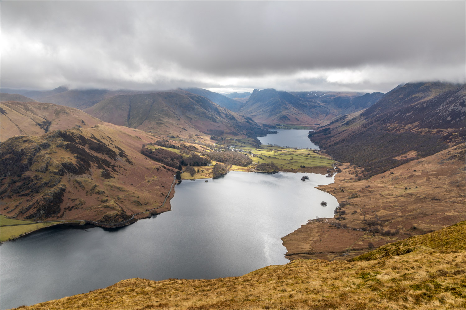
We walk beyond the south top for a wider view of Crummock Water and Buttermere

Zooming in

Having retraced our steps to the saddle between the north and south tops we descend into lonely Mosedale, a vast empty wilderness

The Mosedale Holly Tree, a conspicuous landmark and the only tree in lakeland to be identified by name

After a steep descent we arrive at the valley path, and turn right along it

Low Fell ahead...


Looking back along the path to Hen Comb

Just beyond this point we join our ascent route and and from here retrace our steps

Looking across to Grasmoor

Lorton Vale

Grasmoor again...


Rannerdale Knotts right of picture

Looking back to Mellbreak

The Kirkstile Inn

A golden end to the walk, with Mellbreak in the background

On the way back we stopped the car to admire the classic view from Foulsyke looking over Crummock Water to Haystacks and Great Gable
