
Route: Low Fell
Area: Western Lake District
Date of walk: 8th July 2016
Walkers: Andrew and Gilly
Distance: 4.5 miles
Ascent: 1,500 feet
Weather: Cloudy but plenty of sunny spells, very clear
We only had time for a short local walk today thanks to miserable weather earlier in the day – Low Fell would fit the bill perfectly. We’ve been up here dozens of times and never tire of it
We started from our usual place, a small layby just outside the village of Thackthwaite. After walking into the village we turned off the lane and followed a stony path, quite overgrown at first but gradually opening out onto fields. We then joined the drove road above the intake wall which has lovely views towards Crummock Water, but which gradually disappear as the final push to the summit ridge is made
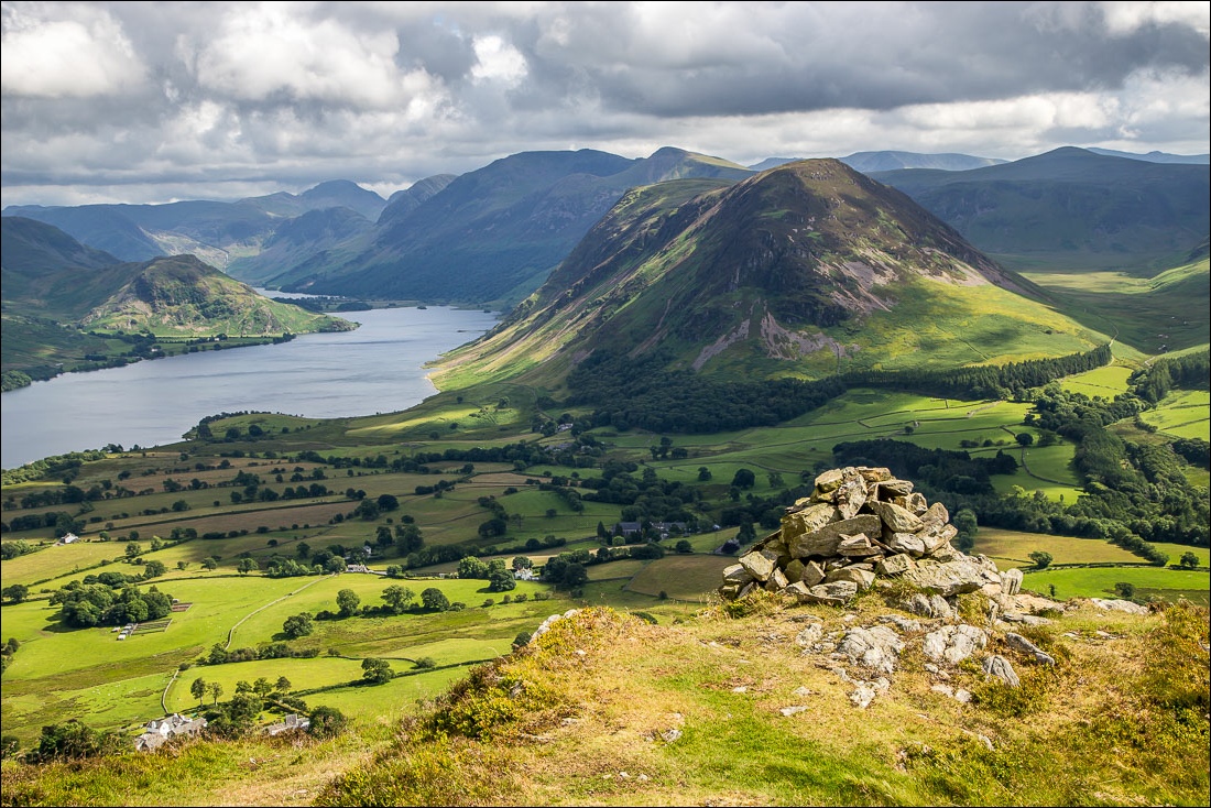
Once on the ridge we soon gained the north top, but it would be a major omission to turn back here. The views are good, but in order to enjoy the main attraction of the fell it’s necessary to continue further along the ridge to a cairn just below the south top from where, in the words of Alfred Wainwright ‘the view is of classical beauty, an inspired and inspiring vision of loveliness…a scene of lakes and mountains arranged to perfection’
AW’s words are no exaggeration and having gained the south top and gazed in silent awe for a while we retraced our steps back to the start
For other walks here, visit my Find Walks page and enter the name in the ‘Search site’ box
Click on the icon below for the route map (subscribers to OS Maps can view detailed maps of the route, visualise it in aerial 3D, and download the GPX file. Non-subscribers will see a base map)

Scroll down – or click on any photo to enlarge it and you can then view as a slideshow

Looking across Lorton Vale from the layby at the start of the walk

Thackthwaite - watch out for speeding squirrels

We follow this line of trees as far as the intake wall ahead

Looking back to Whiteside

Mellbreak

Great Gable in the background

When we reach the intake wall ahead we turn right

Looking back across the valley

High Lorton


Crummock Water comes into view as we look back down the path

Lorton Dodd, leading up to Whiteside

Crummock Water again

Onwards and upwards

Looking back to Lorton Dodd again…

…and towards High Lorton

We walk round the redundant gate

Fellbarrow

Scotland just visible in the far distance

Not far to the summit ridge now

Bonnie

We’re now on the summit ridge, with several ups and downs before we reach its end

Rannerdale Knotts

Whiteside

Ladyside Pike and Lorton Dodd

Crummock Water - the view gets better further along the ridge

Looking down into Lorton Vale


The insignificant cairn on the north top of Low Fell - but this is not mission accomplished, carry on to the south top

Mellbreak is well seen from here

Gilly lifts the dog gate for Bonnie

The south top of Low Fell, it’s best to carry on to the next cairn for an even better view…

Loweswater and Holme Wood

Looking west to the Irish Sea

Looking down to Loweswater village and Crummock Water

Lonely Mosedale between Mellbreak and Hen Comb

The view described by Wainwright in the introduction…

…a timeless view - our children 20 years ago from this special place

After contemplating those views we retrace our steps and descend back to Lorton Vale

Later that day, sunset over Lorton Vale
