
Route: Low Fell
Area: Western Lake District
Date of walk: 24th November 2017
Walkers: Andrew, Gilly, James and Nicola
Distance: 4.5 miles
Ascent: 1,500 feet
Weather: Sunny at first, then clouded over with some hail
Low Fell is one of my favourite places in the Lake District. I’ve been up here dozens of times (3 dozen to be precise) and never tire of the superlative views
We started from the small layby just outside the village of Thackthwaite. After walking into the village we turned off the lane and followed a stony path, quite overgrown at first but gradually opening out onto fields. We then joined the drove road above the intake wall, which has lovely views towards Crummock Water, but which gradually disappear as the final push to the summit ridge is made. Once on the ridge the north top is soon gained, but it would be a major omission to turn back here
The views are good from the cairn on the north top, but in order to enjoy the main attraction of the fell it’s necessary to continue further along the ridge to the south top from where, in the words of Alfred Wainwright, ‘the view is of classical beauty, an inspired and inspiring vision of loveliness…a scene of lakes and mountains arranged to perfection’.
AW’s words are no exaggeration and having gained the south top we retraced our steps back to the start in deteriorating weather
For other walks here, visit my Find Walks page and enter the name in the ‘Search site’ box
Click on the icon below for the route map (subscribers to OS Maps can view detailed maps of the route, visualise it in aerial 3D, and download the GPX file. Non-subscribers will see a base map)

Scroll down – or click on any photo to enlarge it and you can then view as a slideshow

Before we set off on today's walk James and I visited Buttermere to catch the early morning light - this is the boathouse at the head of the lake

Horse Close and Comb Beck

High Crag and High Stile

Haystacks

Pine tree and Comb Beck

Burtness Wood


Hassnesshow Beck looking towards Fleetwith Pike

Back home, a red squirrel in the hail...


Low Fell seen from the other side of Lorton Vale - our route will take along the length of the ridge

The start of the walk from the small layby near Thackthwaite

We walk through the village, taking care to avoid speeding squirrels

We leave the lane at Thackthwaite House to follow a rocky path uphill

Looking across Lorton Vale to Ladyside Pike and Lorton Dodd

We follow the easy path towards the ridge

Whiteside, living up to its name today

Whiteside and Grasmoor on the left, Great Gable in the far distance

Another view back across Lorton Vale

We follow a path above the dry stone wall which contours around the fellside

Looking back to Crummock Water...

...and again from higher up

Lorton Vale

Fellbarrow to our right

High Lorton

Looking back towards Lorton

Fellbarrow...


James and Nicola gain the ridge and Nicola takes a photo of the wonderful view ahead....

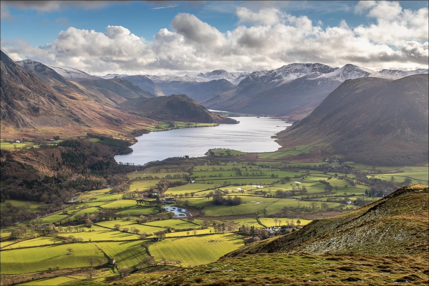
....this one - Crummock Water and an array of snow clad fells

Looking across to Skiddaw in the background

Crummock Water

Whiteside and Grasmoor on the far side of Lorton Vale

Gilly on the north top of Low Fell

The view gets even better as we walk towards the south top

Summit cairn on the south top, with Haystacks, Great Gable and the High Stile Range beyond

James and Nicola at the far end of the ridge

Looking north west towards the Solway Firth and Scotland

Cairn at the end of the ridge

Looking down into lonely Mosedale - the weather quickly deteriorated at this point and we retraced our steps

A passing hail shower on the way back to the end of a wonderful walk
