
Route: Humber Bridge
Area: East Yorkshire and Lincolnshire
Date of walk: 10th November 2017
Walkers: Andrew and Gilly
Distance: 4.3 miles
Ascent: 300 feet
Weather: Sunny, very cold
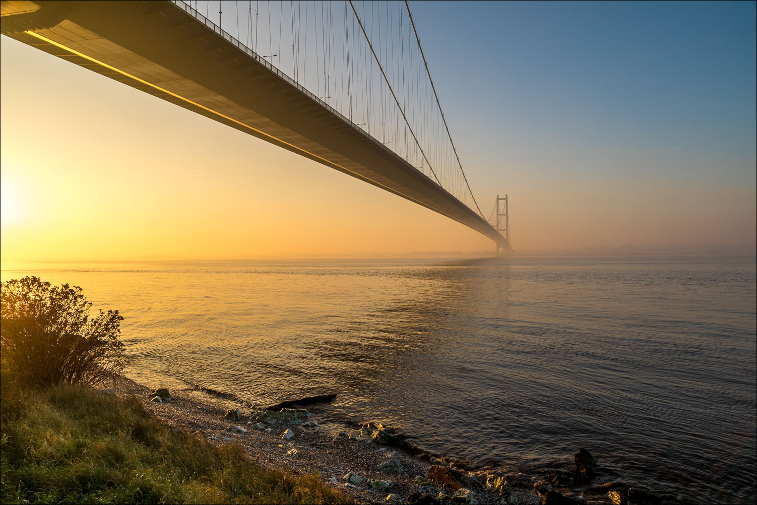
The Grade I listed Humber Bridge links Lincolnshire and Yorkshire and is a civil engineering wonder – a perfect combination of form and function. When it was opened in 1981 it was the longest single span suspension bridge in the world. It now ranks 8th, but remains the longest that can be cycled or walked across. I’ve driven over the bridge on numerous occasions but until today hadn’t walked across
The walk can be started from either the north or south bank – for us it was more convenient to start on the north, and after parking in the Humber Bridge Country Park (which is a nature reserve and worthy of a walk in its own right) we made our way to over to the steps leading up to the bridge. We followed the sign to the East Path and would return along the West Path, hoping – vainly as it turned out – for some sunset views along the estuary on the way back
We were soon on the path across the bridge and enjoying extensive views east towards Hull. I don’t need to waste time explaining the route – any direction other than forwards or backwards would result in an abrupt end to the walk
When we arrived on the south bank we descended down the steps, walked under the bridge, and climbed back up again to start the return journey along the West Path. For the benefit of bird watchers it’s worth mentioning that Far Ings Nature Reserve is within easy reach at this point and if time permits it’s well worth a visit. As for us, time was running short in view of an afternoon start and the lack of daylight hours in November, so we simply followed the path back to the start, marvelling not only at the views but also at the feat of engineering which enabled us to enjoy them
For other walks here, visit my Find Walks page and enter the name in the ‘Search site’ box
Click on the icon below for the route map (subscribers to OS Maps can view detailed maps of the route, visualise it in aerial 3D, and download the GPX file. Non-subscribers will see a base map)

Scroll down – or click on any photo to enlarge it and you can then view as a slideshow

The Humber Bridge at dawn earlier this week...


...and at sunset a couple of weeks ago...


Sunrise on the day of the walk, and a view of The Deep from Victoria Pier Hull - one of the most spectacular aquariums in the world

The start of today's walk as we leave the Humber Bridge Country Park

We follow the sign for the East Path and cross under the bridge

The start of the crossing over the Humber Estuary, which is about 1 mile from bank to bank...


Looking down on the railway line into Hull...

...and the busy A63

Observation platform

Hessle Foreshore, where the opening photos were taken

Above the estuary now

Looking ahead to Lincolnshire

Wrap up warm if you follow this walk in winter, there's no shelter from bitingly cold winds

These are holding us up - there's enough cable to go twice round the planet, and each cable is strong enough to hold 19,400 tonnes

Precise measurements were taken to account for the curvature of the earth - the towers are 36mm further apart at the top than the bottom

The path is also used by cyclists

Heavy lorries cause a slight wobble, but the bridge is constantly moving and bends 3 metres in the middle in 80mph winds, then returns to its original shape when the winds drops

The South Bank of the Humber

Waters Edge Country Park...


Barton on Humber

Autumn colours in the park

Barton again

We leave the path just beyond this sign, walk under the bridge, and climb the steps up the other side

Start of the return leg along the West Path

Barton Reedbed and Far Ings Nature Reserve...


Approaching the North Tower, 510 feet tall and with foundations 26 feet deep

The Country Park and Cliff Mill


We pass over the A63 again

The setting sun at the end of today's walk

Sunset down by the foreshore...

