
Route: Around Hackness
Area: North York Moors
Date of walk: 5th January 2015
Walkers: Andrew and Gilly
Distance: 5.5 miles
Ascent: 500 feet
Weather: weak sun, cold
We started from Derwent View Hackness for the second day running, and walked out of the unspoilt village, crossing the footbridge over the river Derwent near Wrench Green. At this point, the walk could easily be combined with yesterday’s walk to make an 11 mile walk around the pretty village of Hackness and its surroundings – a good introduction to the beautiful countryside to be found in this area
After passing through Wrench Green, we climbed up Lang Gate and across Coomb Slack, from where there are great views back over Hackness
We then walked through the curiously named Mount Misery and descended towards Troutsdale. There followed a short section of road walking along the quiet valley road, and when we reached the River Derwent we followed the riverbank all the way back into Hackness
The path was very muddy and slippery at times, and I took great care not to repeat an accident I’d had about 5 years ago, when I slipped into the river and went up to my neck in freezing water, losing a camera, gps and phone in the process. I vividly recall Gilly’s hysterical laughter as I plodded disconsolately back to the car, water pouring out of my pockets. Needless to say, I wasn’t laughing
There were no accidents today, and since we didn’t start the walk until 2pm, the sun was setting by 4pm when we arrived back in Hackness – thankfully dry on this occasion
For other walks here, visit my Find Walks page and enter the name in the ‘Search site’ box
Click on the icon below for the route map (subscribers to OS Maps can view detailed maps of the route, visualise it in aerial 3D, and download the GPX file. Non-subscribers will see a base map)

Scroll down – or click on any photo to enlarge it and you can then view as a slideshow

Marsh Tit (could be Willow Tit, very hard to tell the difference) at Birdwatchers car park Forge Valley before we started the walk

Derwent View Hackness - we started the walk here but anyone not staying at the cottage could park at the village hall nearby

Passing by Mill Farm as we walk out of the village

We cross the footbridge over the River Derwent

Looking back to the footbridge and Walker Flat Wood

Wrench Green

Climbing up Lang Gate

We turn off Lang Gate to take the track to Comb Slack Farm

Looking across to Derwent View, centre of picture

A view back over Hackness, with Hackness Hall in the distance (see yesterday’s walk for closer views of the Hall)

Gilly heads into Coomb Slack

Looking back towards Hackness……

…..and again

Chapman Banks Wood

Wood House Plantation (where there are a couple of very muddy sections)

We emerge from the plantation

Walking towards Mount Misery

Heading down towards Troutsdale

Almost back down to valley level

A short road section along Estell Lane, with Mount Misery up on the right of the picture

Just beyond Little Hilla Green we leave Estell Lane to follow a path along the bank of the River Derwent

The River Derwent

We follow the river bank all the way back to Hackness

It’s a delightful path, though there are one or two muddy and slippery sections along the way

The riverside path emerges from woodland onto open fields


Sunset approaches and the light begins to fade further

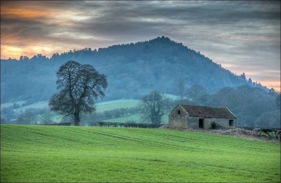
An old stone barn near Hackness

Looking back along the path

The start point - Derwent View, but the River Derwent is between us and I have to walk nearly a mile to progress a few yards………

………but who cares in scenery like this? The stone barn again, looking back towards Mount Misery


The final section along the riverbank

Back to the footbridge over the Derwent……

……and back to Hackness
