
Route: Grange Fell
Area: Central Lake District
Date of walk: 8th July 2017
Walkers: Andrew
Distance: 3.5 miles
Ascent: 1,100 feet
Weather: Sunny
I parked in the National Trust Bowderstone car park and from here followed a path which goes through woodland and then bracken, gradually curving around the steep crags above
A rocky staircase then leads to Long Moss near the summit of the fell. Grange Fell has 3 separate tops, King’s How being the loveliest, though slightly lower than nearby Brund Fell. Today I visited King’s How. From the summit there is a superb view over Derwent Water looking one way and Borrowdale looking the other
A direct descent from here is out of the question thanks to the crags on the west side of the fell, so I followed a narrow path which snakes round the other side of the fell and which eventually brought me down to the Borrowdale road. I followed the road for a short distance – there’s a narrow footpath most of the way – then crossed over at the sign indicating the Bowderstone. I followed this path through the woods, past the massive Bowderstone and back to the car park
What Grange Fell lacks in height it more than makes up for in beauty – the walk was a joy every step of the way, and although it was a Saturday in peak holiday season I didn’t see another soul until the end of the descent from the fell
For other walks here, visit my Find Walks page and enter the name in the ‘Search site’ box
Click on the icon below for the route map (subscribers to OS Maps can view detailed maps of the route, visualise it in aerial 3D, and download the GPX file. Non-subscribers will see a base map)

Scroll down – or click on any photo to enlarge it and you can then view as a slideshow

The day before the walk, some birdlife in the garden...

Siskins on the birdbath

Good to see a house sparrow, once so common

Yellowhammer

...and a red squirrel

A wonderful sunset promised better weather

Dark clouds beyond Fellbarrow looking like islands on fire

Next day, the start of the walk from the National Trust Bowderstone car park

A wonderful woodland section as the path circumvents the crags of King's How


Looking back to Castle Crag

A full frontal assault of the fell is out of the question for ordinary mortals

Birch trees enhancing the wonderful scenery...


The start of a steep climb up a rocky staircase

Bonnie waits for me to catch up

A glimpse of Derwent Water through the trees

Birches

Onwards and upwards

Grange Crags

Heather in bloom

More birch trees

Ether Knott and Brund Fell

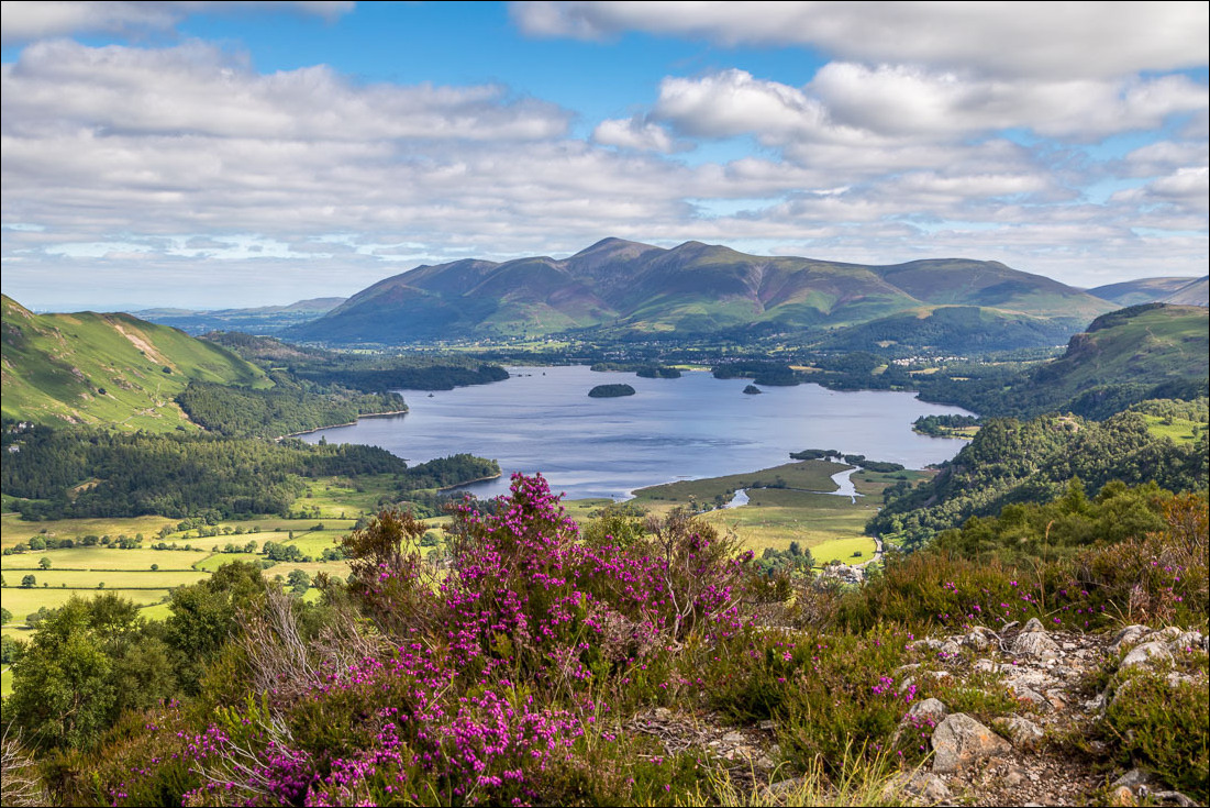
A view of Derwent Water and the Skiddaw range as I approach the top of the fell

Last push to the summit

The knobbly terrain which characterises Grange Fell

Derwent Water from the summit of King's How

Top dog

Turning away from Derwent Water, Borrowdale comes into view

Bowl of beauty

Rosthwaite and Stonethwaite

Looking east as I descend into Borrowdale

I pass by this lonely birch tree

Castle Crag below

The River Derwent bottom right


I follow a narrow path down the fellside....


A Dark Green Fritillary


Lower down, the path becomes harder to follow in bracken which is sometimes shoulder high

A short road section with a narrow footpath on the left

A short diversion to the adjacent River Derwent in order to give Bonnie a cooling down

Water off a dog's back

Path back through the woods

I pass by the Bowder Stone...

...and disused Quayfoot Quarry at the end of a wonderful walk
