
Route: Catstycam and Birkhouse Moor
Area: Eastern Lake District
Date of walk: 10th August 2017
Walkers: Andrew
Distance: 8.5 miles
Ascent: 2,600 feet
Weather: Light cloud at first, then sunny
Å, Glaramara, Catstycam – my 3 latest walks – such appealing and poetic names and the name seems to add to the attraction and romance of the walk somehow. Today it was the turn of Catstycam. At a height of 2,917 feet it’s the 10th highest in the district but is overshadowed by its proximity to Helvellyn. As Wainwright says ‘if Catstycam stood alone, remote from its fellows, it would be one of the finest peaks in lakeland’
I set off from Glenridding, parking near the excellent outdoor clothing shop named, appropriately, catstycam.com. I walked out of the village beside Glenridding Beck, which flooded in December 2015 with devastating consequences for the village. After leaving the village I continued along the north foot of Birkhouse Moor and past the old Greenside Mine. This was very easy going as the path climbed gently uphill though this part of the route lacked views, being hemmed in by fells on either side
As I approached Red Tarn things became more interesting, with views of Swirral Edge ahead, mighty Hellvellyn, and the silhouette of walkers, like a line of soldier ants, teetering along Striding Edge. I followed a path leading up to Swirral Edge and on reaching the edge turned sharp right to make the final push to the summit of Catstycam. I had the place to myself, which was good as there’s not much room for company on the small pointed top, which drops away sharply in all directions
I retraced my steps down to Red Tarn and after passing by the Hole-in-the-Wall followed a lovely path beside a dry stone wall to Birkhouse Moor. A small detour is needed to visit the so called summit cairn, which is actually lower than the ground which precedes it, but it’s a worthy place for a cairn as there’s a wonderful view over Ullswater from here. I retraced my steps from the cairn and continued the descent beside Mires Beck back into Glenridding to conclude a great day out in the eastern fells
For other walks here, visit my Find Walks page and enter the name in the ‘Search site’ box
Click on the icon below for the route map (subscribers to OS Maps can view detailed maps of the route, visualise it in aerial 3D, and download the GPX file. Non-subscribers will see a base map)

Scroll down – or click on any photo to enlarge it and you can then view as a slideshow

A dawn visit to the head of Crummock Water before we headed east

Woodhouse Island

High Ling Crag

Back home, a red squirrel in the garden

Later in the morning, the start of the walk from the car park near catstycam.com walking shop

I follow the path out of the village beside Glenridding Beck


Glenridding Dodd

I follow the path up the Glenridding valley

Looking back to Place Fell and Bleaberry Knott

Approaching the disused Greenside Mine

Looking back

Greenside Mine, which produced mainly lead, but was closed in 1962

Waterfall in Glenridding Beck just beyond the mine

The shapely pointed peak of Catstycam comes into view as I turn the corner

My route will take me to the left and then round the back of the fell

Keppel Cove behind an old sheepfold

Looking back down the path to a heather clad Sheffield Pike

Another view back as I approach the head of the valley

Helvellyn comes into view, and I follow the path to the right leading to Swirral Edge

Swirral Edge - this leads up to busy Helvellyn, but I'll turn sharp right to climb a deserted Catstycam

Looking down over Red Tarn and Striding Edge above it

A view along Swirral Edge

Path to the summit of Catstycam

Looking back to Helvellyn

A thrilling moment as Ullswater comes into view from the small pointed top of Catstycam

Looking down on the route I'd taken to get here - the path to the right leading away from Greenside Mine

Helvellyn in all its glory

Red Tarn

Raise

I retrace my steps to Red Tarn, and can see my descent path snaking its way into the distance

Red Tarn and Helvellyn...


Walkers on Striding Edge, like a line of soldier ants

Looking back to Catstycam on the right, and the path I'd followed centre of the picture

We arrive at the Hole-in-the-Wall and Bonnie climbs the ladder stile - but we're not going that way

We follow an immaculately maintained dry stone wall along Birkhouse Moor

Looking back to Catstycam...

...and to Striding Edge and Helvellyn

Ullswater comes into view above the wall

I make a short diversion to the summit cairn on Birkhouse Moor (which isn't the highest point of the fell)

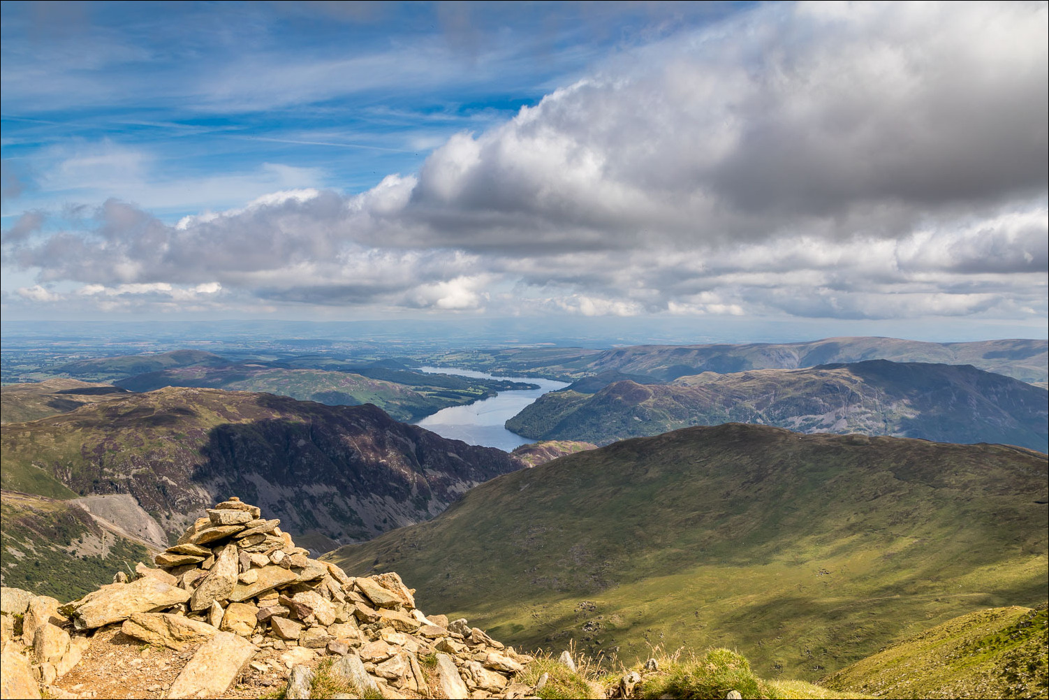
But the cairn is well placed as it enjoys this view over Ullswater

The conical shape of Catstycam is echoed in the cairn

Start of the descent, with wonderful views of Ullswater most of the way

Glenridding and the head of Ullswater

Ullswater again

Heather in full bloom

I continue to descend beside the dry stone wall

Ullswater...

...and zooming in on Glenridding - from here it's a short stroll back into the village and the end of a fabulous walk
