
Route: Beinn Dhubh
Area: Scotland, Isle of Harris
Date of walk: 9th March 2018
Walkers: Andrew and Gilly
Distance: 9.0 miles
Ascent: 2,100 feet
Weather: Sunny at first, cloudier later with a few showers
As mountains go Beinn Dhubh is a rather featureless place, but what makes it very special is its location – probably the best viewpoint on the island. This walk had been at the top of our list since we arrived on Harris but so far the weather had kept us confined to lower level walks. Today we awoke to sun and blue skies so without ado we left our base at Blue Reef Cottages and drove over to the Losgaintir (Luskentyre) road. About half a mile down the road we parked the car near a gate to start the long climb. We crossed Allt Tobhtan Mhic via the stepping stones, which were like blocks of ice in the cold conditions and we had to take care here
The remainder of the ascent was straightforward in terms of gradient, but there were no paths and the ground was juicy to say the least. There were some wonderful retrospective views and these, and the thought of what lay ahead, motivated us to soldier on. Eventually we reached the main ridge line, the gradient eased, and it was a simple climb to Beinn Losgaintir. The views from here were superlative, and we could even see St Kilda in the distance, some 50 miles away. As if this was not enough, a pair of eagles soared overhead, making this a never to be forgotten moment – the long slog up the mountainside was forgotten and forgiven in an instant
The way ahead was obvious, even though pathless, and we followed the line of the ridge first down and then up to our next summit – Beinn Dhubh. The views from here were just as good as our research had promised. I’ll let the photos describe the scene as no words of mine can adequately describe it
After a picnic just below the summit it was time to start the descent. In truth this was rather a chore, despite the views ahead, and turned into a seemingly endless tramp through heather as we picked our way between rocks and boggy sections. As we’d found before, there was no path but we had no difficulties in navigation and it was a relief to finally reach terra firma near a rock headland
We walked across the headland and instead of following our planned route we decided to add some extra mileage by detouring along Traigh Rosamol – it would be unthinkable to miss a walk along this most beautiful of beaches on a day such as this. After rounding the bay we were forced inland by the sea, and climbed up to Losgaintir village to join the narrow road. From here it was a simple matter of following the road back to the start
This had been a red letter day, and a truly memorable walk. It had been quite hard going thanks to the mostly featureless terrain and the lack of paths, but we regarded that as the price of the ticket to enable us to enjoy some of the finest views we’ve ever seen. When we arrived back at our base, I noticed that I’d just fallen short of a milestone – today’s walk meant that I’d clocked up 4,999 miles on this site since starting it in 2013
Click on the icon below for the route map (subscribers to OS Maps can view detailed maps of the route, visualise it in aerial 3D, and download the GPX file. Non-subscribers will see a base map)

Scroll down – or click on any photo to enlarge it and you can then view as a slideshow

Our last full day on Harris, and we awake to blue skies. From our base Blue Reef Cottages we can see today's target - Beinn Dhubh - right of picture

It was a short drive to the start of the walk, and this is our view across Luskentyre beach from the start point

We walk back along the Luskentyre road for a few yards...

...and then turn off through this gate to start the ascent

Looking back across Luskentyre beach to Seilebost

Zooming in

Another view back as we gain height

We pass by a small unnamed lochan

Onwards and upwards

Another frozen lochan

Not far to go before we gain the ridge line

We reach a small cairn atop Sron Godamuil, and from there the gradient eases as we head north

Some snow still lying around

The mountains of North Harris come into view as we pass by another small cairn

Beinn Losgaintir ahead, and beyond it Beinn Dhubh

We keep to the right of the ridge line in order to enjoy the wonderful views over Loch a' Siar to An Cliseam, the highest mountain on the Outer Hebrides

Zooming in on North Harris

Looking back along the grassy ridge

A heavenly few minutes as we reach the summit cairn on Beinn Losgaintir, with views to both sides...

...looking over Luskentyre...

...and now looking across to North Harris

As if this were not enough, we were then treated to the sight of a pair of golden eagles soaring overhead - magical

We continue along the ridge, enjoying more glorious views

A down and an up to Beinn Dhubh

North Harris again

Looking back to Beinn Losgaintir

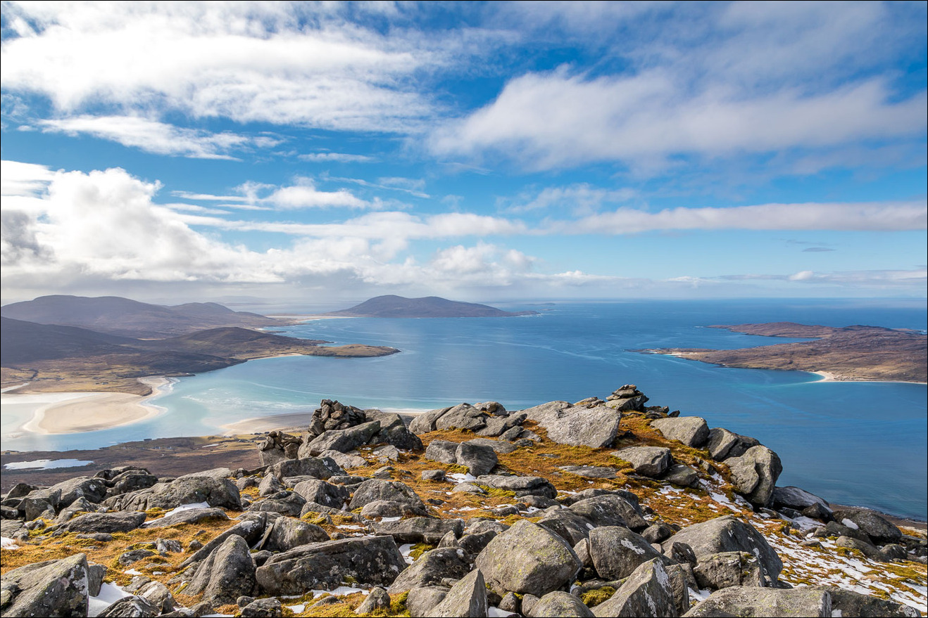
Summit of Beinn Dhubh at 1,660 feet, about 1,000 feet lower than An Cliseam right of picture

The view over Luskentyre and the west coast of Harris

We start the long descent, with these views ahead of us all the way

North Harris

Taransay on the right

A few snowy patches on the way down, which were easily avoided and we didn't need to put our microspikes on


Our return route will take us along Traigh Rosamol below, right of picture

Taransay

We're aiming for the rocky headland below, which we'll cross at its widest point

Back down to sea level at the start of the short walk across the headland

Looking along the lazy beds back up to Beinn Dhubh

Looking back to a rainbow as we walk towards Traigh Rosamol...


Traigh Rosamol - we could have shortened the walk here, but for obvious reasons chose to walk along the beach


The rainbow still showing well as we descend to the sands...

North Harris in the background

A walk along Traigh Rosamol...


Looking back to Beinn Dhubh

North Harris

Beinn Dhubh again above the dunes

The sea dictates that we leave the beach here, so we head up to Luskentyre village

We follow a path by the side of the Commonwealth Military Cemetery

The remainder of the walk is along the quiet Luskentyre road...

Looking across the beach - Traigh Losgaintir

Well placed benches

The car is just around the corner, and here ends a fantastic walk - one of the very best - and we felt privileged to have seen such scenery in such good conditions

Beautiful light on the way back to Blue Reef Cottages, and I stopped the car a couple of times to take these photos of Luskentyre


Farewell to Beinn Dhubh right of picture, and farewell to Harris at the end of a wonderful short walking holiday
