
Route: Angletarn Pikes
Area: Far Eastern Lake District
Date of walk: 14th October 2015
Walkers: Andrew and Gilly
Distance: 7.1 miles
Ascnet: 1,500 feet
Weather: Sun and blue skies, clouded over halfway
The Martindale area is well known as a sanctuary for red deer and it’s also well known that mid October is rutting time. A walk up Angletarn Pikes would satisfy today’s ambition to climb a fell and see some wildlife action while doing so
Alfred Wainwright – as ever – suggested the best route. After parking by Martindale Old Church we followed the path along the valley to Dalehead. Instead of turning directly uphill, we followed a route recommended by Wainwright which passes below Heck Crag but which has ‘fallen out of favour simply because few now know of it’. I have no idea why the route has fallen out of favour as it was wonderful every step of the way, and enhanced by the solitude, the roaring of the red deer stags and the screeching of buzzards. We saw no-one else on the path and it was an absolute delight
We emerged above Angle Tarn – a beautiful scene – and after enjoying our picnic we carried on round the tarn to ascend Angletarn Pikes. Our descent route took us along the ridge of the fell as far as Bedafell Knott, where we turned off the main path and then descended the flanks of the fell before rejoining the path back to the start
For much of the time today we were accompanied by the sound of bellowing stags laying claim to their harems and warning off rivals. It was a wonderful soundtrack to a perfect walk
For other walks here, visit my Find Walks page and enter the name in the ‘Search site’ box
Click on the icon below for the route map (subscribers to OS Maps can view detailed maps of the route, visualise it in aerial 3D, and download the GPX file. Non-subscribers will see a base map)

Scroll down – or click on any photo to enlarge it and you can then view as a slideshow

Before we headed east, I visited Crummock Water at dawn to capture the reflections in the water…


Later that morning, the start of the walk from Martindale Old Church

Looking along Howe Grain as we cross Christy Bridge

We follow the quiet lane along the valley


The Nab - our route takes us further along the valley to the right of the fell

A little further along we had our first red deer sighting, and I was glad I’d brought the telephoto lens along

Dale Head

Looking along Bannerdale


Beda Fell on the right - our path follows the line of the dry stone wall rising up the flanks of the fell

Red deer herd - one of several we saw in Bannerdale

A bellowing stag…

…and a young one

Our path is very faint in parts, and clearly not used often, but the wall makes navigation an easy affair

Heck Crag

Looking back along Bannerdale

The faint path snakes round Heck Crag

Head of Bannerdale

A last look back along the valley before we gain the ridge

Angle Tarn and the Helvellyn range in the background

Angletarn Pikes - we will take the path rising diagonally up the fellside beyond the tarn

The tarn again from our picnic spot

Looking back as we ascend Angletarn Pikes

Looking down into Deepdale

A glimpse of Ullswater from just below the summit

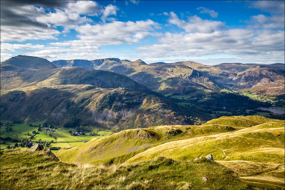
Catstycam in the centre, from the summit of Angletarn Pikes

Start of the descent as we follow the ridge towards Beda Fell, before returning into Bannerdale below

Looking down into Bannerdale, we could hear but not see the red deer stags near the head of the valley

Helvellyn in the background, and the pointed outline of Catstycam

Descending to Bannerdale

Dale Head, from where we retrace our steps back to the start

Walking towards Hallin Fell

Back to the start - Martindale Old Church

Back home, a red squirrel in the garden

